Hodge Close Explore
A Walk in Cumbria
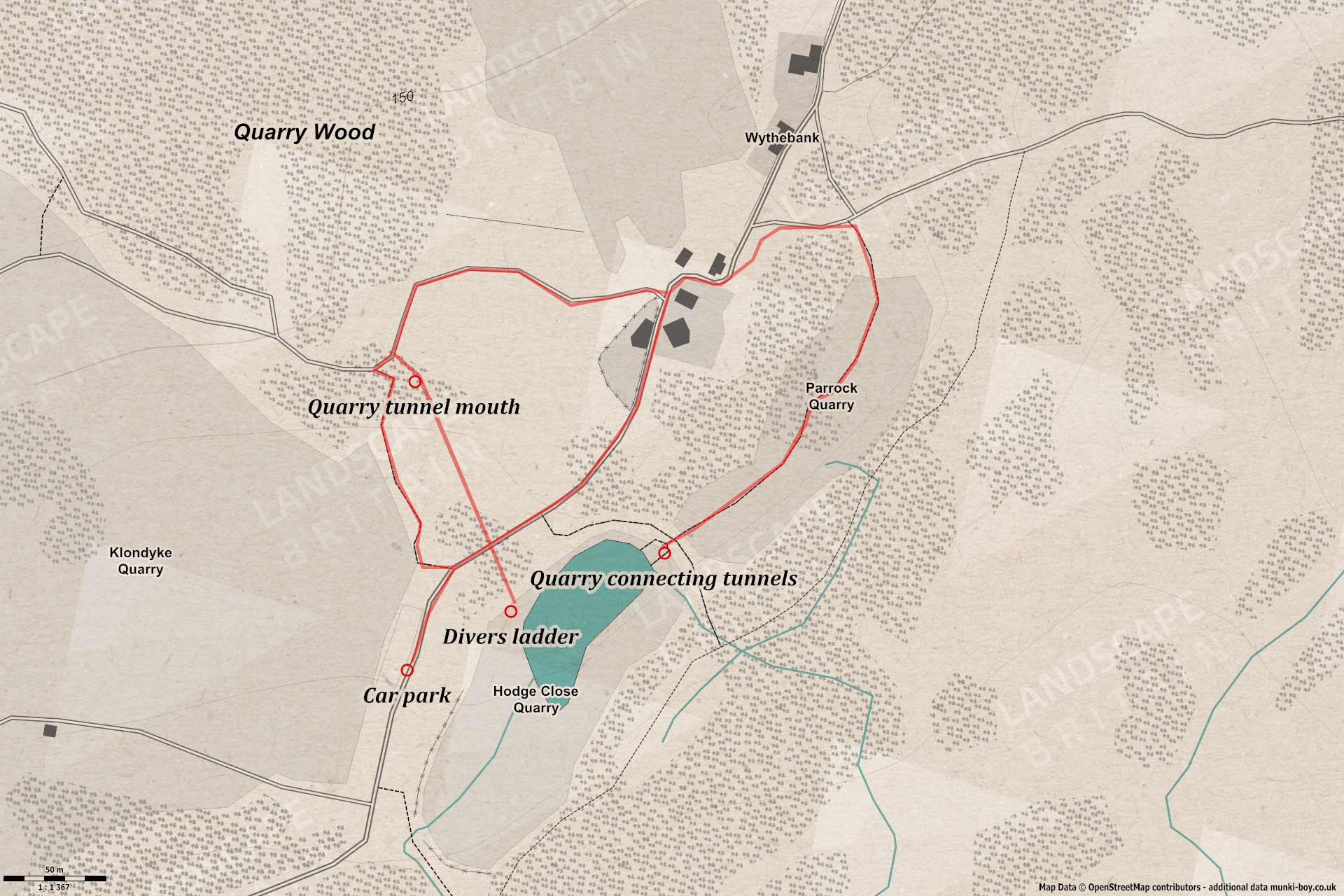
Walk spec.
Difficulty: Dangerous
Basic length: 1.45Km (approx.)
Terrain:
- Dangerous heights
- Deep water
- Large boulders
- Loose rock
- Mud
- Mud tracks
- Old mines
- Steep slopes
- Wet stream bed
This walk is more of an explore and is dangerous so I don’t recommend you do it unless you have some experience with descending rocky slopes, not falling off sheer cliffs, wading through flooded tunnels, avoiding falling rocks and not drowning in deep water in a fairly remote location that would require mountain rescue to help you.
Having said that, parts of this route are regularly used by divers visiting the dive site in the flooded Hodge Close quarry and there’s generally a few people around on sunny days. The walk is strenuous in places and the area has warning signs all around about falling rocks, dangerous drops etc. So be prepared for getting in and out of the quarries safely. There is a section of old quarry tunnel used to access one shore of Hodge Close that is usually wet, with the water level maybe thigh-height or more so it might be impassible at times.
“DANGER - STEEP UNFENCED ROCKFACES - DEEP WATER - Roofing slate has been quarried here for over 200 years please respect this area and be aware of all possible dangers” National Park Authority and Leconfield Estates
Although the walk is only approximately 1.45 Km, if you’re bothering with this dangerous walk then you’ll probably want to add a good deal of distance (time) for pottering round the quarries and tunnels.
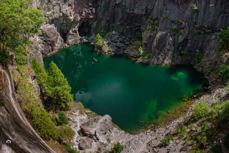
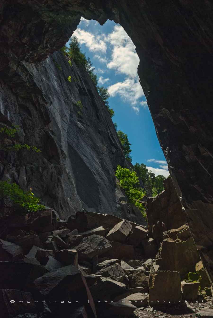
Looking down into Hodge Close
1. Parrock Quarry
From the car park above the East side of Hodge Close quarry, have a careful look over the edge if you like? Careful you don’t disturb any climbers coming up the cliff. Then set off in a Northeasterly direction along the main track towards Wythebank, with Hodge Close then Parrock Quarry to your right. There’s usually a few people abseiling or climbing up the cliffs at the sides here, looks impressive but there can be a few tied ropes along the ground so be careful if you go over towards the edge.
Upon reaching the stone cottage buildings near a sharp bend to the right then left, check out the local building stone used. Just as the track straightens out you can bear right to head towards the top-end (Northeast) of Parrock Quarry where you can see a few bits of old iron bolted into the rock and other industrial remains. Nearby you can find a steep descent into the quarry down a curving path that leads to the quarry floor.
There are a few paths along the quarry leading in a Southwesterly direction that is following the long axis of the quarry toward Hodge Close, but there are a lots of interesting things to see all round the quarry. Keep an eye out for danger though, rock faces and slopes can be unstable and so can “caves” or tunnels found there. Beware of falling rocks if there’s any climbers about, or just in general. There’s also plenty of iron sticking out here and there sometimes quite sharp so don’t impale yourself.
Path down into Parrock Quarry
Parrock Quarry
2. Giant Skull
Once the Southwestern face of the quarry is reached we are presented with some fantastic looking openings in the quarry face leading through to Hodge Close down at water level. Note the remains of an old crane overhanging the water, among other interesting features. As you look around you might notice the opening of the old quarry tunnel to your right on the Southwest wall of the quarry with a weird ladder coming down. Sometimes it’s possible to see some divers entering the water from the tunnel area. There are old cars and vans sunk in the quarry and other tunnels to explore if you have diving skills.
There are some seams of white quartz visible in the rocks around. If you’re hoping to take the ‘skull’ picture at Hodge Close, you’re probably standing in the eye-sockets right now.
Once we’re finished on this side of the quarry we must make our way back to the opposite end of Parrock Quarry to ascend back out the way we came in and further still back to the stone cottage we passed earlier.
A tunnel linking Hodge Close to Parrock Quarry
3. Time to Get Wet
The next part of the route will enter Hodge Close quarry along an old stone tunnel that has a stream in the bottom. We’ll be required to wade along part of the tunnel so now is the time to bail out, or at least make this your last thing to do before heading back to the car park as you’ll probably be wet, unless you have waders or a wet suit.
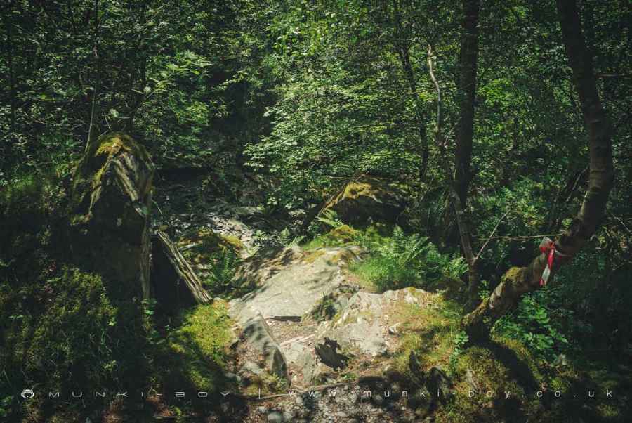
From the stone cottage head downhill to the West following a track that gently zig-zags until curving to the left for a while. At the end of the curve and just before a bend to the right, find a small stream to your left, (Southeast) and follow it a short way to where it issues from a rock cut tunnel heading into the hillside toward Hodge Close quarry.
If you don’t want to go into the tunnel you can make your way over to the old Klondyke Quarry which has an assortment of dangers like loose rubble, old mines, unsafe rock faces and industrial remains but isn’t usually wet like the old quarry tunnel here. Or just head up the rocky path to the car park.
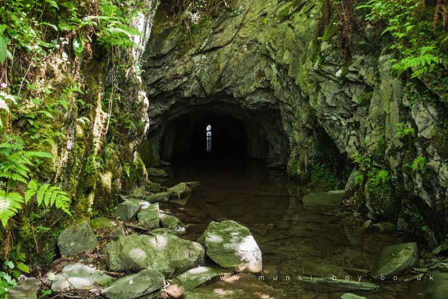
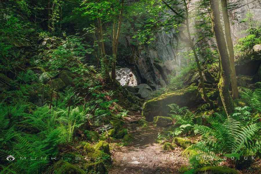
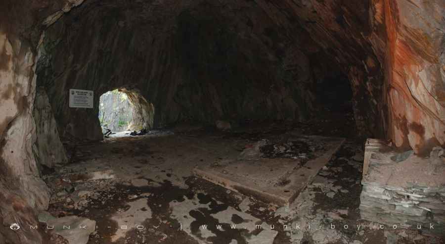
The old quarry tunnel leading into Hodge Close
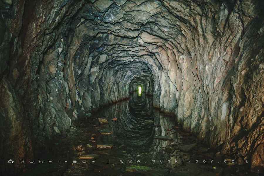
The old quarry tunnel leading out of Hodge Close
4. Divers Ladder
Heading more-or-less straight the end of the tunnel should be visible after a short way once we head in. The floor is pretty solid but can have loose stones or rubble that can trip the unwary. The water level can get high so I hope you moved your phone to a higher pocket already. I’ve waded through a few times and haven’t had a problem but the divers that use this tunnel to access the quarry probably have wet-suits. The water is cold and the tunnel is dark but after a while the water level drops and we reach a chamber cut into the rock with some concrete structural remains on the floor. There is a collapsed tunnel leading off to the Southwest and a rock ‘door’ leading outside. The opening emerges part way up a sheer rock face so be careful. There’s usually some kind of ladder (did you see from the opposite shore?) to climb down if you want to explore the area.
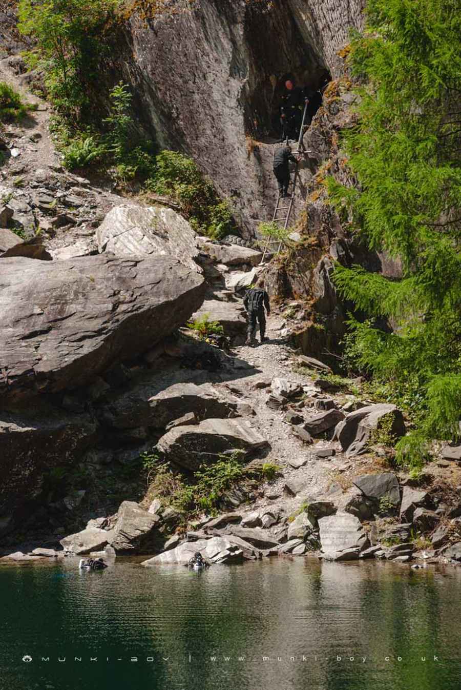
Divers at the quarry tunnel ladder in Hodge Close
5. Hodge Close
The path leading upwards to our right (Southwest) from the opening leads to some good viewpoints, I’m not sure if you can head down to the water’s edge for the skull view from here, it’s a bit rugged and the water level varies. The collapsed tunnel leads to some more chambers that have collapsed ceilings and some openings to the outside, not much fun there. Towards the North-most corner of the quarry there is a sump where divers can come up from the level below.
Once you’re done exploring we’ll need to head back up the tunnel the way we came in. Exiting the tunnel at the small stream there is a rocky path leading up to just near the car park.
Not a bad explore on a nice sunny day.
Tunnel entrance to Hodge Close
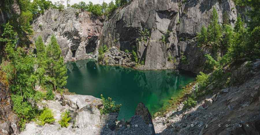
Amazing blue water in Hodge Close
Looking down into Hodge Close
These walks are described for educational purposes only and we make no recommendation that you follow them, do so at your own risk. We accept no liability for your safety or for the reliability of the walk, map, description or anything else.
Mist, Mines and Ruins


Own label and private label building products
We produce, brand and supply for some of the biggest names in the industry. Read more...