Lansdowne Monument by munki-boy
Lansdowne Monument
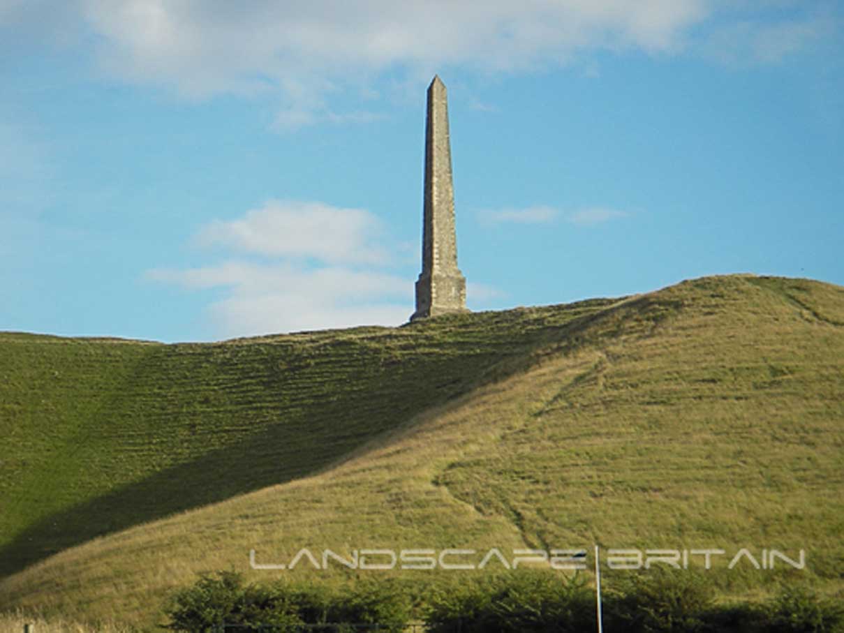
The Lansdowne monument also known as Cherhill Monument, is a stone obelisk, which was erected in 1845 by the 3rd Marquis of Lansdowne in memory of the physician and surveyor Sir William Petty.
Lansdowne Monument is in North Wessex Downs AONB, a designated Area of Outstanding Natural Beauty.
Created: 27 November 2016 Edited: 29 November 2023
Lansdowne Monument
Local History around Lansdowne Monument
There are some historic monuments around including:
Pair of bowl barrows on West Down, 550m east of Witch PlantationBowl barrow 930m west of Cherhill Monument, Cherhill Down.Round barrow 1260m NNE of Baltic Farm, 75m south of Roman Road, forming part of a barrow cemetery situated on North DownBowl barrow 130m SSW of Beckhampton Buildings forming part of a barrow cemetery situated on North DownFour round barrows 740m east of Kitchen Barrow, forming part of a round barrow cemetery on All Cannings DownBowl barrow 950m SSW of Beckhampton Plantation, forming part of a round barrow cemetery on Horton DownBell barrow forming part of a round barrow cemetery on North DownBowl barrow 1km west of Tan HillLong barrow and abutting bowl barrow 700m WSW of Beckhampton Buildings, forming the focus of a barrow cemetery on North DownA henge, four Bronze Age barrows and part of a Roman road 500m south west of Fox CovertLong barrow 650m WSW of Shepherds' ShoreBowl barrow at east end of Morgan's HillBowl barrow on Kitchen Barrow HillSaucer barrow 250m east of Windmill Hill: part of the Windmill Hill round barrow cemeteryRemains of watermill 500m east of Freeth FarmField system E of Kitchen Barrow HillSection of Roman Road 560m north east of Beckhampton BuildingsBell barrow 660m south east of Beckhampton Buildings, forming part of a round barrow cemetery on Horton DownAll Cannings Cross, an Early Iron Age settlement siteBowl barrow forming part of a round barrow cemetery on Allington DownTwo saucer barrows and a pair of bowl barrows 750m SSW of Beckhampton Plantation, forming part of a round barrow cemetery on Horton DownBowl barrow on King's Play Hill 510m north of Hill CottageBell barrow situated between Bishop's Cannings Down and Easton DownLinear earthworks forming part of a field system on Bishop's Cannings DownBowl barrow situated 500m SSW of Shepherds' ShoreLong barrow on Horton DownThree Bronze Age barrows 200m NNW of Down Barn forming part of a barrow cemetery situated on North DownMedieval settlement 520m north east of Lower Beversbrook FarmBowl barrow 1km north-east of Baltic FarmBowl barrow forming part of a cemetery 800m east of Kitchen BarrowBowl barrow 550m north-east of Baltic FarmBowl barrow 190m north east of Nolands Farm, YatesburyTwo bowl barrows 670m south east of Beckhampton Buildings, forming part of a round barrow cemetery on Horton DownBeckhampton round barrow cemetery 150m north east of the `Waggon and Horses'Bell barrow on Easton DownPair of bowl barrows forming part of a round barrow cemetery on Allington DownTwo bowl barrows in Roundway Hill CovertFour bowl barrows forming part of a cemetery 270m east of long barrow on Roughridge HillRound barrow forming part of the Fox Covert round barrow cemetery on West DownPair of bowl barrows 650m south west of Beckhampton Buildings, forming part of a round barrow cemetery on North DownBowl barrow 400m west of Cooks PlantationSaucer barrow on North DownA causewayed enclosure, the core of a round barrow cemetery, part of a prehistoric field system and an associated mortuary enclosure on Windmill HillBowl barrow 750m south-west of Manor Farm: part of the Windmill Hill round barrow cemeteryEnclosed Iron Age farmstead 450m south of Down Barn on Bishop's Cannings DownSaucer barrow 600m west of Beckhampton BuildingsBowl barrow 500m west of the wireless station on Morgan's Hill; part of a group of three bowl barrowsBowl barrow 750m south west of Beckhampton Buildings forming part of a round barrow cemetery on North DownSaucer barrow 910m west of Cherhill Monument, Cherhill Down.Bowl barrow on King's Play Hill, 420m north of Hill CottageBowl barrow 150m east of the wireless station on Morgan's HillRound barrow cemetery and part of a field system 200m south of Beckhampton PenningTwo bell barrows and a bowl barrow forming part of a round barrow cemetery adjacent to the Devizes to Beckhampton road on North DownBowl barrow 60m east of Roundway Hill CovertEnclosure on Horton DownLong barrow on King's Play Hill, 430m north west of Hill CottageBowl barrow situated 60m west of Beckhampton Buildings forming part of a round barrow cemetery on North DownBowl barrow forming part of a linear round barrow cemetery on Allington DownHarepit Way linear boundaryGroup of three bowl barrows 250m north east of Shepherds' ShoreBowl barrow 640m south west of Beckhampton Buildings forming part of a round barrow cemetery on North DownBowl barrow 840m north-east of Baltic FarmPair of Bronze Age bowl barrows 400m south west of Beckhampton Buildings, forming part of a cemetery on North DownLong Stones long barrow 150m north of Beckhampton HouseOldbury Camp hillfort, bowl barrow and cross dyke on Cherhill DownCross dyke 230m south west of Cherhill MonumentGrange Stables bell barrowLong barrow on Easton DownBowl barrow 700m south-east of Windmill HillGrange bowl barrow 130m north west of The Grange Stables bell barrow, BeckhamptonEarthwork enclosure on Allington DownBowl barrow 300m south of Fox Covert forming part of the Fox Covert round barrow cemetery on West DownBowl barrow forming part of a round barrow cemetery situated 120m NNW of Down Barn on North DownAvebury Long Stones 380m east of The Grange Stables, BeckhamptonPair of bell barrows and a pair of bowl barrows forming part of a barrow cemetery at Baltic FarmRound barrow in Mount Wood, 300m north-east of Upper LodgeBowl barrow on Calstone Down, 500m south of Witch PlantationPair of round barrows 200m SSE of Windmill Hill: part of the Windmill Hill round barrow cemetery.Ten barrows forming part of Fox Covert round barrow cemetery, West Down.Section of Wansdyke and associated monuments from east of The Firs to the eastern side of Tan HillSquare earthwork enclosure 450m north west of Baltic Farm on Morgan's HillOliver's Camp and two round barrows outside Oliver's CampStone circleSquare enclosure 350m north of Wansdyke on Bishop's Cannings DownKitchen Barrow: a long barrow on Kitchen Barrow HillBowl barrow 200m east of Windmill Hill: part of the Windmill Hill round barrow cemetery.Group of small enclosures on Horton Down, 910m north east of Easton Down long barrowTwo bowl barrows 400m south of Tanhill PenningPair of round barrows and section of linear earthwork NE of the gallops on West DownBowl barrow 200m south of Windmill Hill: part of the Windmill Hill round barrow cemeteryRybury campBowl barrow 1150m north-east of Baltic FarmBowl barrow 1070m NNW of Baltic Farm forming part of a barrow cemetery on North DownTwo bowl barrows 320m south-east of Little LondonBowl barrow 840m west of Cherhill Monument, Cherhill Down.Medieval rural settlement at QuemerfordCross dyke 450m west of Cherhill MonumentPair of bowl barrows situated on the south east of Bishop's Cannings DownCross dyke 520m north east of Cherhill MonumentCross ridge dyke on Morgan's HillLong barrow 85m west of Cherhill MonumentDitch W of Tanhill FairPair of Bronze Age bowl barrows 200m WSW of Beckhampton Buildings forming part of a barrow cemetery situated on North DownBowl barrow 800m south of Hemp KnollField system 275yds (250m) N of Field BarnBowl barrow 610m south east of Beckhampton Buildings, forming part of a round barrow cemetery on Horton DownBowl barrow 350m north-east of White Horse PlantationBowl barrow 750m south-east of Windmill HillBowl barrow forming part of a round barrow cemetery 120m north of the Devizes to Beckhampton road on North DownBell barrow 600m west of Beckhampton BuildingsBowl barrow 230m west of The Grange, BeckhamptonBowl barrow forming part of a linear round barrow cemetery on Allington DownSouth Street long barrow, 70m south east of the Long StonesFive round barrows 1040m NNE of Baltic Farm forming part of a barrow cemetery on North DownBowl barrow 300m east of Furze KnollBell barrow forming part of a round barrow cemetery 135m ENE of Baltic FarmHorslip long barrow, 450m north-west of Horslip Bridge.Linear boundary earthwork and associated field system on Cherhill DownRoundway Hill Farm round barrowsEleven round barrows 1000m north of Baltic Farm forming part of a barrow cemetery, and a probable enclosed Iron Age farmstead on North DownWansdyke: 460yds (420m) SE of Broads Green to 266yds (240m) NE of Paddock Farm.


