
Rhosllanerchrugog
Rhosllanerchrugog is a Village in the county of Wrexham (Wrecsam).
Rhosllanerchrugog postcode: LL14 2LH
There are great places to visit near Rhosllanerchrugog including some great towns and historic buildings.
There are a several good towns in the area around Rhosllanerchrugog like Wrexham.
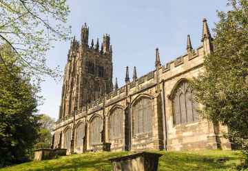
There are a several good historic buildings in the area around Rhosllanerchrugog like St Giles Church in Wrexham.
Rhosllanerchrugog History
There are some historic monuments around Rhosllanerchrugog:
- Offa's Dyke: South Section at Coedpoeth
- Offa's Dyke: Vron Farm Section
- Creigiau Eglwyseg Round Barrow
- Caer Estyn Hillfort
- Brymbo Lead Smelting Works
- Ruabon Mountain Round Barrow
- Pen-y-Brongyll Round Barrow
- Wat's Dyke: Section extending from Middle Sontley to Black Brook Bridge
- Penrhos Engine House
- Darland Wood Round Barrows
- Cefn y Gader Round Barrows
- Gardden Camp
- Wat's Dyke: Garden Village Section
- Bersham Colliery: No 2 Winding Gear
- Offa's Dyke: section 300yds (270m) long, S of Pen-y-Bryn Also in Clwyd: Wales
- Creigiau Eglwyseg Round Barrows & Earth Circle
- Offa's Dyke: Chirk Park Section extending NE from the Lake
- Motte castle adjacent to Oaklands Hall, Chirk Bank
- Offa's Dyke: Caeau-Gwynion Section
- New Minera Lead Mine
- Wynnstay Colliery Winding Engine House
- Offa's Dyke: Section S of Aberderfyn Road
- Caergwrle Packhorse Bridge
- Offa's Dyke: Section S from Pen y Coed
- Medieval cross in St Mary's churchyard, Dudleston
- Wat's Dyke: Sections N & S of the Court
- Wat's Dyke: Section extending from Black Brook Bridge to Pentre-Clawdd
- Castell Dinas Bran
- Offa's Dyke: Brymbo Hill Section
- Bryn Alyn Camp
- Offa's Dyke: Mountain View Section
- Roman military site at Rhyn Park
- Wynnstay Colliery Walker Fan House
- Castell y Waun Castle Mound
- Caergwrle Castle
- Erddig Mound & Bailey Castle
- Bank of Six Vertical Limekilns at Minera Quarry
- The Holyhead Road: the Chirk Embankment and earlier trackways
- Offa's Dyke: Cadwgan Hall Section, extending from River Clywedog to the Railway
- Maes Maelor Round Barrow
- Offa's Dyke: Section SW from Tatham Bridge
- Offa's Dyke: Section S of Bryn yr Owen Farm
- Meadow Shaft, Minera
- Offa's Dyke: Section extending 477m from Coed Talon Banks
- Cas-Gan-Ditw Round Barrow
- Esclusham Mountain Cairn, Minera
- Cadwgan Hall Mound
- Wat's Dyke : Section South of Ruthin Road
- Brymbo Ironworks: Early Blast Furnace, Cast House & Foundry
- Nant Mill Wood Shaft Mounds
- Craig Arthur Kerb Cairn
- Offa's Dyke: Section extending 117m NW of Church
- Eyton Old Hall Moat
- Offa's Dyke: Section N & S of Tan-y-Cut
- Offa's Dyke: Chirk Park Section extending 340m NE of Home Farm
- Wat's Dyke: Section W of Ty-Gwyn
- Minera Halvans Plant
- Wrexham Churchyard Ornamental Wrought Iron Gates and Screen
- Abersychnant Cairn
- Graig cairn
- Moated Site near Groesfoel Farm, Rhostyllen
- Craig-y-Forwyn Cairn
- Bryn Alyn Round Barrow
- Plas Maen Cottage round barrow
- Pen y Gaer Hillfort
- Offa's Dyke: Vron Section
- Cefn y Cist Cairn
- Offa's Dyke: Chirk Castle Section extending NE from Castle Mill
- Penycae Cairn
- Two Cairns on Ruabon Mountain
- Taylor's Shaft, Minera
- Offa's Dyke Section South of River Gwenfro
- Offa's Dyke: Section S from Cae Llewellyn
- Minera Hoffman Limekiln
- Wat's Dyke: Section extending from Erddig Park to Middle Sontley
- Creigiau Eglwyseg Stone Circle
- Offa's Dyke: Pentre-Bychan Hall Section, extending 540m S from Bron-Wylfa
- Offa's Dyke: Section N & S of Plas-Offa
- Offa's Dyke: Sections N & S of Bryn yr Owen Colliery
- Wat's Dyke at Crispin Lane, Wrexham
- Hillbury Round Barrow
- Offa's Dyke: Y Gardden Camp Section
- A 1.43km length of the Ellesmere Canal and associated features at Chirk Bank
- Wat's Dyke: Section N of Rhydyn Farm
- Ffrith Roman Site
- Pen-y-stryt round barrow
- Pentre round barrow
- Offa's Dyke: Section extending 120m from Railway to Bronwylfa Road, Legacy
- Offa's Dyke: Section in Plas Power Park
- Offa's Dyke: Plas Power Section
- Bridge 157m E of Ffrith Village
- Gatewen Hall round barrow
- Offa's Dyke: Section South of Brymbo Colliery
- Eglwyseg Mountain Round Barrow
- Pont y Cysylltau
- Wat's Dyke: Section SSW of Wrexham Station, 130m Long
- Cryn-y-Brain Round Barrow
- Offa's Dyke: North Section at Coedpoeth
- Hadfod-y-Bwlch Round Barrow
- Offa's Dyke: Section N of Home Farm
- Bersham Ironworks
- Croes-Foel Round Barrow
- Wat's Dyke: Section extending from Pentre-Clawdd to Wynnstay Park
- Fairy Oak Round Barrow
Places to see near Rhosllanerchrugog
History of Rhosllanerchrugog
The development of the village can be attributed largely to the coal seams of north-east Wales that pass near it. The burgesses of Holt were granted the right to dig for coal at Rhos in their borough charter of 1563. A coal mining community was established during the 18th century, and grew substantially from the 1840s onwards. Unlike many other mining villages in the district and in other parts of Wales, the majority of early immigration to Rhos was from Welsh-speaking upland agricultural areas in West Wales, giving the village a distinct linguistic identity which it has retained until the present day. The proportion of Welsh-speakers in Rhos did not fall below 50% until the time of the 1981 census.


