Stert
Stert is a Town in the county of Wiltshire.
There are great places to visit near Stert including some great historic monuments, ancient sites, historic buildings, country parks, lakes, parks and villages.
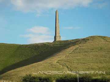
Don't miss Lansdowne Monument, Cherhill White Horse, and Avebury's historic monuments if visiting the area around Stert.
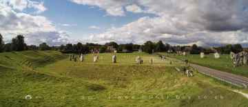
There are a number of ancient sites near Stert including Avebury, West Kennet Long Barrow, The Sanctuary, Silbury Hill, and Barbury Castle.
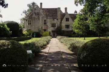
Stert is near some unmissable historic buildings like Avebury Manor,
Coate Water Country Park, Barbury Castle Country Park, and Lydiard Park are great places to visit near Stert if you like country parks.
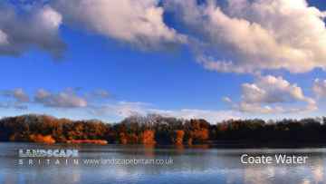
There are a number of lakes near to Stert including Coate Water.
There are a number of parks near to Stert including Lydiard Park.
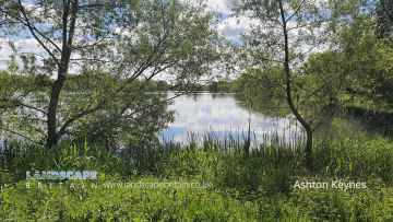
The area close to Stert boasts some of the best villages including Ashton Keynes.
Stert History
There are some historic monuments around Stert:
- Moated site 300m north-east of Potterne Park Farm
- Multiple trackway between and north of Round Clump and Dogtail Plantation
- Field system E of Kitchen Barrow Hill
- Bowl barrow forming part of a linear round barrow cemetery on Allington Down
- Two bell barrows and a bowl barrow forming part of a round barrow cemetery adjacent to the Devizes to Beckhampton road on North Down
- Ditch W of Tanhill Fair
- The Hatfield Earthwork: a henge enclosure, henge and remains of monumental mound at Marden
- Boundary earthwork from East Down to Orcheston Down
- Hill Wood bowl barrow
- Bowl barrow 150m east of the wireless station on Morgan's Hill
- Pair of Bronze Age bowl barrows 400m south west of Beckhampton Buildings, forming part of a cemetery on North Down
- All Cannings Cross, an Early Iron Age settlement site
- Bowl barrow 1150m north-east of Baltic Farm
- Boundary feature on Ball Down
- Earthwork enclosure on Allington Down
- Round barrow north of Summer Down
- Enclosure on Horton Down
- Square enclosure 350m north of Wansdyke on Bishop's Cannings Down
- Harepit Way linear boundary
- Bowl barrow 1km north-east of Baltic Farm
- Grange bowl barrow 130m north west of The Grange Stables bell barrow, Beckhampton
- Bowl barrow 500m west of the wireless station on Morgan's Hill; part of a group of three bowl barrows
- Pair of round barrows and section of linear earthwork NE of the gallops on West Down
- Round barrow forming part of the Fox Covert round barrow cemetery on West Down
- Enclosure on Summer Down
- Cross ridge dyke on Morgan's Hill
- Saucer barrow 910m west of Cherhill Monument, Cherhill Down.
- Bowl barrow 300m east of Furze Knoll
- Medieval village site
- Bowl barrow 610m south east of Beckhampton Buildings, forming part of a round barrow cemetery on Horton Down
- Shrunken medieval village site E of Avebury Trusloe
- Pair of bowl barrows on West Down, 550m east of Witch Plantation
- Cross dyke 230m south west of Cherhill Monument
- Long barrow 85m west of Cherhill Monument
- Pair of bell barrows and a pair of bowl barrows forming part of a barrow cemetery at Baltic Farm
- Square earthwork enclosure 450m north west of Baltic Farm on Morgan's Hill
- Section of Wansdyke and associated monuments from east of The Firs to the eastern side of Tan Hill
- Bowl barrow on Kitchen Barrow Hill
- Saucer barrow on North Down
- Group of three bowl barrows 250m north east of Shepherds' Shore
- Round barrow near Charlton Clumps
- Four earthwork enclosures on All Cannings Down
- Kitchen Barrow: a long barrow on Kitchen Barrow Hill
- Bowl barrow forming part of a round barrow cemetery 120m north of the Devizes to Beckhampton road on North Down
- Devizes Castle
- Ell Barrow, long barrow
- Round barrow cemetery and part of a field system 200m south of Beckhampton Penning
- Two saucer barrows and a pair of bowl barrows 750m SSW of Beckhampton Plantation, forming part of a round barrow cemetery on Horton Down
- Boundary feature, western section of Long Ditch across Wilsford Down
- Field system on Penning Down
- Enclosure on Black Heath Down
- Orcheston Down Romano-British landscape
- Two bowl barrows in Roundway Hill Covert
- Bowl barrow forming part of a cemetery 800m east of Kitchen Barrow
- Section of Roman Road 560m north east of Beckhampton Buildings
- Long barrow 650m WSW of Shepherds' Shore
- Long barrow in Barrow Plantation, East Down
- Caen Hill locks
- Medieval rural settlement at Quemerford
- Bowl barrow 230m west of The Grange, Beckhampton
- Bowl barrow 950m SSW of Beckhampton Plantation, forming part of a round barrow cemetery on Horton Down
- Long barrow on Easton Down
- Bowl barrow 60m east of Roundway Hill Covert
- Two bowl barrows 400m south of Tanhill Penning
- Bowl barrow 550m north-east of Baltic Farm
- Bowl barrow forming part of a round barrow cemetery situated 120m NNW of Down Barn on North Down
- Bowl barrow forming part of a round barrow cemetery on Allington Down
- Bowl barrow 300m south of Fox Covert forming part of the Fox Covert round barrow cemetery on West Down
- Cross dyke 520m north east of Cherhill Monument
- Bowl barrow 640m south west of Beckhampton Buildings forming part of a round barrow cemetery on North Down
- Rybury camp
- Bowl barrow on King's Play Hill 510m north of Hill Cottage
- Pair of Bronze Age bowl barrows 200m WSW of Beckhampton Buildings forming part of a barrow cemetery situated on North Down
- Saucer barrow 600m west of Beckhampton Buildings
- Oliver's Camp and two round barrows outside Oliver's Camp
- Bowl barrow 840m west of Cherhill Monument, Cherhill Down.
- Field system and settlement north of Chapperton Down
- Round barrow 1260m NNE of Baltic Farm, 75m south of Roman Road, forming part of a barrow cemetery situated on North Down
- Boundary earthwork east of Church Hill
- Bowl barrow 350m north-east of White Horse Plantation
- Two bowl barrows north of Rowbury Lane
- Site of an oval stone circle and part of an adjacent field system 700m SW of West Kennet long barrow.
- Nuthills Roman villa
- Thornham Down prehistoric and medieval landscapes
- Beckhampton round barrow cemetery 150m north east of the `Waggon and Horses'
- Enclosure south-east of Candown Copse
- Bowl barrow at east end of Morgan's Hill
- Bowl barrow 800m south of Hemp Knoll
- Enclosure north of Chirton Gorse
- Pair of bowl barrows 650m south west of Beckhampton Buildings, forming part of a round barrow cemetery on North Down
- Two bowl barrows 670m south east of Beckhampton Buildings, forming part of a round barrow cemetery on Horton Down
- Field system 275yds (250m) N of Field Barn
- Pair of bowl barrows forming part of a round barrow cemetery on Allington Down
- Wansdyke: 460yds (420m) SE of Broads Green to 266yds (240m) NE of Paddock Farm
- Bowl barrow 400m west of Cooks Plantation
- Cross dyke 450m west of Cherhill Monument
- Bowl barrow 130m SSW of Beckhampton Buildings forming part of a barrow cemetery situated on North Down
- Boundary feature 700m south-west of The Plantation, West Lavington Down
- Long barrow on Horton Down
- Moated site and fishpond north-west of Pinhills Farm
- Bell barrow forming part of a round barrow cemetery 135m ENE of Baltic Farm
- Linear boundary earthwork and associated field system on Cherhill Down
- Linear earthworks forming part of a field system on Bishop's Cannings Down
- Chapperton Down Prehistoric and Romano-British Landscape
- Enclosed Iron Age farmstead 450m south of Down Barn on Bishop's Cannings Down
- Deserted medieval village E of Manor Farm
- Barrow north-west of Weatherhill Scrub
- Four round barrows 740m east of Kitchen Barrow, forming part of a round barrow cemetery on All Cannings Down
- Bowl barrow 750m south west of Beckhampton Buildings forming part of a round barrow cemetery on North Down
- Two boundary earthworks on the west of Rushall Down
- Boundary earthworks on Wilsford Down
- Bowl barrow situated 60m west of Beckhampton Buildings forming part of a round barrow cemetery on North Down
- Three Bronze Age barrows 200m NNW of Down Barn forming part of a barrow cemetery situated on North Down
- Bowl barrow 1km west of Tan Hill
- Roundway Hill Farm round barrows
- Bell barrow 660m south east of Beckhampton Buildings, forming part of a round barrow cemetery on Horton Down
- Bowl barrow 930m west of Cherhill Monument, Cherhill Down.
- The Long Monument
- A henge, four Bronze Age barrows and part of a Roman road 500m south west of Fox Covert
- Bell barrow on Easton Down
- Grange Stables bell barrow
- Barrow east of Chirton Landing Strip
- Enclosure on Marden Down
- Avebury Long Stones 380m east of The Grange Stables, Beckhampton
- Long barrow on King's Play Hill, 430m north west of Hill Cottage
- Pair of bowl barrows situated on the south east of Bishop's Cannings Down
- Long Stones long barrow 150m north of Beckhampton House
- Bowl barrow situated 500m SSW of Shepherds' Shore
- Four bowl barrows forming part of a cemetery 270m east of long barrow on Roughridge Hill
- Bowl barrow on Calstone Down, 500m south of Witch Plantation
- Group of small enclosures on Horton Down, 910m north east of Easton Down long barrow
- Oldbury Camp hillfort, bowl barrow and cross dyke on Cherhill Down
- Eleven round barrows 1000m north of Baltic Farm forming part of a barrow cemetery, and a probable enclosed Iron Age farmstead on North Down
- Bell barrow forming part of a round barrow cemetery on North Down
- Bell barrow situated between Bishop's Cannings Down and Easton Down
- South Street long barrow, 70m south east of the Long Stones
- Bowl barrow 840m north-east of Baltic Farm
- Ten barrows forming part of Fox Covert round barrow cemetery, West Down.
- Long barrow and abutting bowl barrow 700m WSW of Beckhampton Buildings, forming the focus of a barrow cemetery on North Down
- Bowl barrow forming part of a linear round barrow cemetery on Allington Down
- Bowl barrow 1070m NNW of Baltic Farm forming part of a barrow cemetery on North Down
- Bell barrow 600m west of Beckhampton Buildings
- Field system on West Lavington Down
- Bowl barrow on King's Play Hill, 420m north of Hill Cottage
- Strip lynchet system east of Three Corner Firs
- Five round barrows 1040m NNE of Baltic Farm forming part of a barrow cemetery on North Down
- Enclosure and boundary earthwork west of Scraggy Copse