Quidhampton
Quidhampton is a Village in the county of Wiltshire.
Quidhampton postcode: SP2 9AU
There are great places to visit near Quidhampton including some great historic monuments, ancient sites, historic buildings, country parks, lakes, parks and villages.
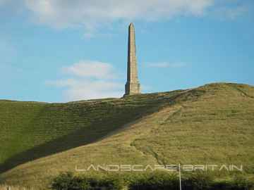
The area around Quidhampton boasts some of the best historic monuments including Lansdowne Monument, Cherhill White Horse, and Avebury.
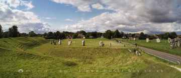
Avebury, West Kennet Long Barrow, The Sanctuary, Silbury Hill, and Barbury Castle are great places to visit near Quidhampton if you like ancient sites.
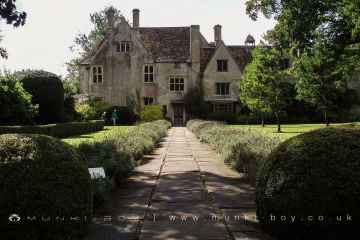
Avebury Manor is one of Quidhampton's best, nearby historic buildings to visit in Quidhampton.
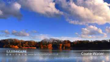
Coate Water Country Park, Barbury Castle Country Park, and Lydiard Park are some of Quidhampton best country parks to visit near Quidhampton.
Coate Water is a great place to visit close to Quidhampton if you like lakes.
Don't miss Lydiard Park's parks if visiting the area around Quidhampton.
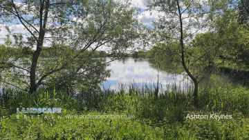
Don't miss Ashton Keynes's villages if visiting the area around Quidhampton.
Quidhampton History
There are some historic monuments around Quidhampton:
- Bowl barrow forming part of a round barrow cemetery 350m north of Springbottom Farm buildings on Wilsford Down
- Round barrow E of Downbarn West
- Bowl barrow 400m south of Normanton Gorse
- Pond barrow south of the A303 and 400m west of Normanton Gorse containing the 'Wilsford Shaft'
- Disc barrow and pillbox within Boscombe Down airfield, 520m south east of the Officers' Mess
- Bowl barrow 150m east of Stonehenge Cottages on A303
- The Giant's Chair bell barrow
- Bowl barrow forming part of Normanton Down round barrow cemetery
- Bowl barrow 350m south west of Normanton Gorse
- Grim's Ditch: Old Lodge Copse to Toyd Clump
- Five bowl barrows and two saucer barrows forming a round barrow cemetery on Winterbourne Stoke Down
- 'Ende Burgh' long barrow
- Bowl barrow within Luxenborough Plantation
- Bowl barrow 300m south west of New King Barrows
- Four bowl barrows 140m north of the A303 on Stonehenge Down
- Wick Down round barrow
- Ruined church of SS Mary and Nicholas
- Churchyard cross
- Earthworks S of Knighton Hill Buildings
- Two bowl barrows on Stoke Down 650m south west of Foxhole Cottage
- The Giant's Grave long barrow
- Lynchets at Southmill Hill
- Vespasian's Camp
- Bowl barrow 230m west of Stonehenge forming part of a round barrow cemetery on Stonehenge Down
- Milestone SE of Yarnbury Castle
- Bowl barrow forming part of a round barrow cemetery 350m north of Springbottom Farm buildings on Wilsford Down
- Linear boundary from south east of Winterbourne Stoke crossroads to south west of The Diamond on Wilsford Down
- Long barrow 700m west of Bride's Farm
- Bowl barrow 320m west of Vespasian's Camp
- Packhorse bridge
- Bowl barrow and a disc barrow in Normanton Gorse, forming part of the Normanton Down round barrow cemetery
- Enclosure NW of Downbarn West
- Bowl barrow 300m WSW of Stonehenge, forming part of a round barrow cemetery on Stonehenge Down
- Barford Down milestone
- Bowl barrow 250m south west of Longbarrow Cross Roads, west of A360
- Earthwork W of Woodford Clump
- Bowl barrow 200m east of Lake Down round barrow cemetery north of Rox Hill
- Two barrows NW of Little Down
- Three bowl barrows 220m west of Vespasian's Camp
- Bowl barrow forming part of the Normanton Down round barrow cemetery
- Croucheston Down Barn round barrow
- Two bowl barrows 700m north west of Normanton Down House
- Clearbury Down round barrow
- Punch Bowl round barrow
- Grovely Castle and earthworks N of Grovely Wood
- Long barrow 600yds (550m) SE of Vanity
- Barrow in Wilton Park
- Ratfyn Barrow
- Bowl barrow on Homington Down, 725m south of Tottens Farm
- Knighton Hill earthwork
- Bowl barrow 400m south east of Longbarrow Cross Roads, east of A360
- Long barrow in Round Clump
- Disc barrow 220m south west of Stonehenge forming part of a round barrow cemetery on Stonehenge Down
- Six bowl barrows forming the greater part of a round barrow cemetery on Wilsford Down 350m north of Springbottom Farm buildings
- Bowl barrow immediately south of the embankment of a disused railway, within Boscombe Down Airfield, 870m south east of The Pennings
- Roman road north east of Vernditch Chase: part of the Roman road between Sorviodunum (Old Sarum) and Vindocladia (Badbury)
- Bowl barrow east of the A360 forming part of the Winterbourne Stoke crossroads round barrow cemetery
- The Poultry Cross
- Winterbourne Stoke West round barrow cemetery, The Coniger enclosure and section of linear boundary earthwork
- Triple bell barrow 530m north of Field Barn on Amesbury Down
- Bowl barrow on the eastern edge of Luxenborough Plantation
- Bowl barrow 250m south of Westfield Farm buildings
- Rockbourne Down, Spring Pond enclosure
- Bell barrow situated 50m north of Normanton Gorse and 170m south of the A303
- Chalk map of Australia 925m south west of Upper Hurdcott Farm
- Village cross
- Hare Warren Control Station
- Pond barrow 700m south of A344 on Winterbourne Stoke Down
- Hydon Hill round barrows
- City rampart E of Council House
- Milford Hill Bridge
- Bowl barrow 300m north west of Lake House
- Bowl barrow forming part of a round barrow cemetery known as the New King Barrows
- Bowl barrow on the north eastern edge of Luxenborough Plantation
- Ten bowl barrows, five disc barrows, a bell barrow, a pond barrow and a saucer barrow forming the Wilsford round barrow cemetery
- Giant's Grave: a long barrow 400m north-west of Down Farm
- Bronze Age enclosure and bowl barrow 100m west of Longbarrow Cross Roads on Winterbourne Stoke Down
- Woodbury ancient villages
- Ancient cultivation terraces
- Bury Orchard ditch
- Romano-British settlement at Stratford sub Castle
- Pond barrow 480m west of Olddown Barn on Amesbury Down
- Seven bowl barrows and a pond barrow forming a round barrow cemetery 200m north of The Diamond on Wilsford Down
- Grim's Ditch
- Ten round barrows forming the Lake Down round barrow cemetery and a section of linear boundary crossing Lake Down
- Group of barrows W of Hooklands Plantation
- Section of a linear boundary from 350m north east of Westfield Farm on Lake Down to Lake Bottom
- Barrow SSW of Melsome's Field barn
- Long barrow on Wilsford Down 300m north of The Diamond
- Bowl barrow 250m north west of Lake House
- Old Sarum
- Bowl barrow 200m WNW of Lake House
- Bowl barrow in Normanton Gorse, forming part of the Normanton Down round barrow cemetery
- Stapleford Castle
- Group of barrows on North Hill Down
- Bronze Age and Romano-British enclosure on Martin Down, east of Bokerley Junction
- Three bowl barrows 150m south of the A303, north of Luxenborough Plantation
- Long barrow on Little Toyd Down, 760m south west of Grims Lodge Farm
- Bowl barrow 70m south of A303
- Round barrow SE of Cowdown Farm
- Three bowl barrows on the southern edge of Luxenborough Plantation
- Bowl barrow immediately east of the A360 forming part of the Winterbourne Stoke crossroads round barrow cemetery
- Bowl barrow 340m east of Stockport
- Bowl barrow south of the A303 and north west of Normanton Gorse
- Lake Barrow Group, North Kite earthwork enclosure, four sections of linear boundary, and a bowl barrow within the North Kite
- Queensberry Bridge
- Mizmaze on Breamore Down
- Clearbury Ring
- Duck's Nest: a long barrow on Rockbourne Down
- Bell barrow 100m east of Stonehenge immediately south of the A344
- Two barrows W of Stoke Down
- Stonehenge, the Avenue, and three barrows adjacent to the Avenue forming part of a round barrow cemetery on Countess Farm
- Hamshill ditches and field system
- Bowl barrow 650m SSE of Stonehenge
- Bowl barrow 450m east of The Diamond south of the A303
- Heale Hill round barrows and earthworks
- Bowl barrow south of Normanton Gorse on the southern edge of Normanton Down
- Grovely Ditch
- Medieval pottery kilns, Milford Farm
- King Barrow and another bowl barrow on Coneybury Hill
- Linear boundary earthwork 250m west of Stockport
- Long barrow and 18 round barrows, forming the greater part of Normanton Down round barrow cemetery
- Long Barrow 800m north-west of Paradise
- Long barrow north east of Winterbourne Stoke crossroads
- Odstock Copse earthwork
- Two linear earthworks in Vernditch Chase
- Linear boundary within Normanton Gorse
- Two bowl barrows and four bell barrows forming the greater part of a round barrow cemetery known as the New King Barrows
- Deserted medieval village, a bowl barrow, and part of a prehistoric field system opposite Lake House in Lake Bottom
- Bowl barrow 540m south east of Druid's Head Farm
- Three bowl barrows 150m south of Normanton Down round barrow cemetery
- Heath Wood earthwork
- Henge monument 300m south of Longbarrow Cross Roads, east of A360
- Bowl barrow 450m north of Springbottom Farm
- Parsonage Down Camp earthwork enclosure and associated field system.
- Linear boundary earthwork on Amesbury Down west of Stock Bottom
- Bowl barrow 240m east of The Penning
- Bell barrow north east of Westfield Farm and 150m south of Wilsford round barrow cemetery
- Bowl barrow known as `Bush Barrow' and two disc barrows south east of Normanton Gorse forming part of Normanton Down round barrow cemetery
- Round barrow 860yds (786m) SE of Knighton Hill Buildings
- Bowl barrow on Little Toyd Down, 650m south west of Grims Lodge Farm
- Bowl barrow on Coneybury Hill, 130m NNE of Luxenborough Plantation
- Long barrow 700m north-west of Tenantry Farm
- Neale's Barrow, round barrow
- Two disc barrows and a bell barrow, 400m east of the Pennings, Earl's Farm Down
- Bowl barrow 50m south of A303
- Three bowl barrows immediately north of the A303 on Stonehenge Down
- Bowl barrow 400m west of Normanton Gorse
- Bowl barrow on Coneybury Hill, 450m south of the A303
- Long barrow 250m north of Normanton Gorse
- Ogbury camp
- Hut Bottom round barrow
- Bowl barrow 50m south west of Rox Hill Clump
- Knighton Hill round barrow
- Hoop Side round barrows
- Eighteen round barrows forming the greater part of the Winterbourne Stoke crossroads round barrow cemetery
- Long barrow 350m south west of the Normanton Down round barrow cemetery
- Two bowl barrows and a levelled barrow 460m north east of Normanton House on Amesbury Down
- Bowl barrow 430m north west of Northdown Barn
- Bowl barrow 700m north of Springbottom Farm
- Field system on Stoke Down
- Henge monument 400m south of Stonehenge Cottages
- Five bowl barrows forming the greater part of a round barrow cemetery 200m south west of Stonehenge on Stonehenge Down
- Bowl barrow 100m south east of the southern edge of The Diamond south of the A303
- Bowl barrow within Boscombe Down Airfield, 160m south east of The Rifle and Pistol Club
- Bowl barrow 120m south of Normanton Down round barrow cemetery
- Two bowl barrows 700m south of Springbottom Farm buildings
- Disc barrow forming part of the Normanton Down round barrow cemetery
- Knighton Roman road (stretching from Reddish Gore to reservoir)
- Harnham Bridge
- Bowl barrow 470m south east of Druid's Head Farm
- Bowl barrow 100m north of Rox Hill Clump
- Two bowl barrows forming part of the Winterbourne Stoke crossroads round barrow cemetery
- Newton Barrow
- Round barrows S of Hare Warren
- Village cross
- Faulston pigeon house
- Two round barrows 300m south of Normanton Down round barrow cemetery