Oare
Oare is a Village in the county of Wiltshire.
Oare postcode: SN8 4JH
There are great places to visit near Oare including some great historic monuments, ancient sites, historic buildings, country parks, lakes, parks and villages.
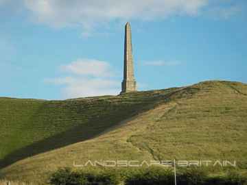
The area around Oare boasts some of the best historic monuments including Lansdowne Monument, Cherhill White Horse, and Avebury.
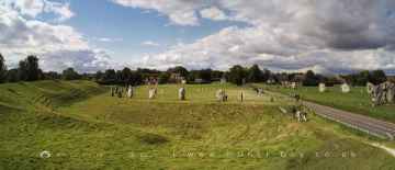
There are a several good ancient sites in the Oare area like Avebury, West Kennet Long Barrow, The Sanctuary, Silbury Hill, and Barbury Castle.
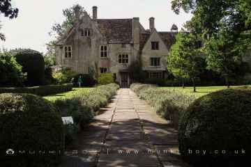
There are a several good historic buildings in the area around Oare like Avebury Manor.
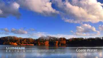
Coate Water Country Park, Barbury Castle Country Park, and Lydiard Park are great places to visit near Oare if you like country parks.
The area around Oare's best lakes can be found at Coate Water.
Lydiard Park is a great place to visit close to Oare if you like parks.
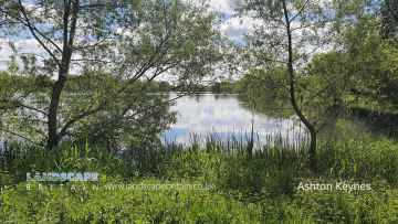
Places near Oare feature a number of interesting villages including Ashton Keynes.
Oare History
There are some historic monuments around Oare:
- Round barrow near Charlton Clumps
- Enclosure on Ogbourne Down
- Bowl barrow 750m north of Rockley Manor: part of the Rockley Plantation barrow cemetery
- Two round barrows west of Hougoumont Farm
- Everleigh Barrows
- The Sanctuary, Overton Hill
- Romano-British settlement and associated earthworks on Coombe Down, 760m east of Bake Barn
- Lidbury Camp, associated trackways and bowl barrow, on Littlecott Down
- 'Giant's Grave' long barrow on Milton Hill
- Bowl barrow 800m south-east of Ogbourne St Andrew Farm
- Bowl barrow 900m SSE of Green Bank
- Earthwork enclosure N of Wansdyke
- Bowl barrow 300m east of Ivy House Farm
- Bowl barrow immediately west of the Ridgeway, 400m north east of its junction with Green Street
- Bowl barrow 400m south-east of Culley's Farm Cottages
- 'The Spectacles'
- Group of four round barrows 300m north west of the junction between the Ridgeway and Green Street on Avebury Down
- Bell barrow and adjacent bowl barrow on Marlborough Common, 120m east of Wootton Bassett Road
- Six bowl barrows 560m north of New Barn: part of a barrow cemetery on Monkton Down
- Two boundary earthworks on the west of Rushall Down
- Bowl barrow 70m north of Rockley Plantation
- Group of five round barrows north-east of the Sanctuary: part of the Overton Hill round barrow cemetery.
- Section of the Wansdyke
- Defended settlement on Aughton Down, 450m north of Croft Barn
- Bowl barrow 750m south-west of Manor Farm: part of the Windmill Hill round barrow cemetery
- Three confluent round barrows 580m west of the Ridgeway, forming part of a Bronze Age round barrow cemetery on Avebury Down
- Bowl barrow north of Jenner's Firs
- Bowl barrow 40m north west of East Kennett long barrow forming part of a cemetery
- Chisenbury Warren Romano-British settlement and associated trackway
- Linear round barrow cemetery 200m ENE of West Kennett long barrow
- Beckhampton round barrow cemetery 150m north east of the `Waggon and Horses'
- Wansdyke: section from S of Furze Hill to Marlborough-Pewsey road
- Round barrow on Easton Down
- Five bowl barrows 600m north-east of Brimslade Farm Cottages: part of the Square Copse barrow cemetery
- Group of barrows on Draycott Hill
- Saucer barrow 620m north of New Barn: Part of a barrow cemetery on Monkton Down
- Bell barrow 75m west of Red Shore
- Bowl barrow forming part of a linear round barrow cemetery on Allington Down
- Knap Hill camp near Alton Priors
- Medieval settlement remains immediately west of The Vicarage
- Group of four round barrows 500m south-east of Avebury Down Barn, forming part of a Bronze Age round barrow cemetery on Avebury Down
- Two bowl barrows 820m north of Rockley Manor: part of the Rockley Plantation barrow cemetery
- Bowl barrow 880m north of Rockley Manor: part of the Rockley Plantation barrow cemetery
- Snail Down barrow cemetery and associated monuments.
- Enclosure east of Baden Down Farm
- Withy Copse ditch
- Bowl barrow 50m south-east of the `Sanctuary' forming part of the Overton Hill round barrow cemetery.
- Field system north-east of Chisenbury Field Barn
- Compton Farm Romano-British and Early Medieval occupation sites and associated cultivation earthworks
- Avebury henge and stone circles
- Thornham Down prehistoric and medieval landscapes
- Disc barrow at Easton Clump
- Two bowl barrows 400m east of Cadley Vicarage
- Devil's Den long barrow, 600m east of White Acre
- Strip lynchet system north of Chisman's Cleeve
- Bowl barrow 800m north-east of Hackpen Barn
- Bowl barrow 900m south west of the junction of the Ridgeway and Green Street, forming part of a round barrow cemetery on Avebury Down
- Bowl barrow 120m west of East Kennett long barrow forming part of a cemetery
- Henge Monument/enclosure, on Everleigh Down, north of Weather Hill Firs
- Pair of bowl barrows 150m north of the Wansdyke on All Cannings Down
- Settlement and field system on Milton Hill (Fyfield Down)
- Bowl barrow 50m south of The Sanctuary on Overton Hill, forming part of the Seven Barrow Hill round barrow cemetery
- Two bowl barrows 350m south east of Baden Down Farm
- Bell barrow 200m north of Rockley Plantation
- West Kennet long barrow, 800m south-east of Silbury Hill
- Three bell barrows and a pillow mound 400m south-west of Knap Cottage
- Bowl barrow 200m east of Windmill Hill: part of the Windmill Hill round barrow cemetery.
- Earthwork enclosure on Allington Down
- Village settlement on Barton Down
- Earthwork NW of New Town Farm
- Earthwork W of New Town Farm
- Bowl barrow 1km north-east of Avebury and 70m north of Green Street
- Two round barrows W of New Town Farm
- Long barrow in Barrow Copse
- Field system south of East Everleigh
- Two bowl barrows 400m south of Summer Down Farm
- Bowl barrow 50m north of Barrow Farm
- Dam of King's fishpond
- Avebury Long Stones 380m east of The Grange Stables, Beckhampton
- Bowl barrow 650m east of Summer Down Farm
- Bowl barrow 800m south-east of Tanhill Penning
- Castle mound
- Round barrow cemetery and part of a field system 200m south of Beckhampton Penning
- Giant's Grave (Martinsell Hill)
- Swanborough Tump
- West Kennett Farm palisaded enclosures
- Bowl barrow 500m north-west of Berwick Bassett Clump
- Prehistoric to post-medieval settlement, cultivation, industrial and funerary remains on Fyfield, Overton and Manton Downs
- Bowl barrow 650m ESE of New Barn, between Avebury Down and Monkton Down
- Bowl barrow 750m east of New Barn
- Bowl barrow forming part of a Bronze Age cemetery 400m north-east of West Kennett Farm on Overton Hill
- Bowl barrow five hundred metres north-west of Baden Down Farm
- Bowl barrow 70m north of Green Street and east of the Avebury henge monument
- Ditch 530yds (484m) SW of Stitchcombe Farm
- Barrow S of Wansdyke
- Earthwork enclosure on Milk Hill
- Three Roman burial mounds, a Bronze Age bowl barrow, a pagan Saxon inhumation cemetery and a short length of Roman road on Overton Hill.
- Romano-British kilns, Column Ride, Savernake Forest
- Bowl barrow 200m north-east of Everleigh Ashes
- Bowl barrow 150m north of the Alton White Horse
- Casterley Camp and associated monuments
- Bowl barrow in The Belt, 350m north east of Hill Barn
- Enclosed settlement 450m north of Bake Barn
- Wick Down Farm earthwork
- Iron Age enclosure on Overton Hill, 600m north west of North Farm
- Silbury Hill: a monumental Neolithic mound west of the River Kennet and south of Avebury village
- Group of round barrows on Rough Hill
- Strip lynchets north-east of East Chisenbury
- Linear barrow cemetery on Hackpen Hill
- Linear earthwork in Savernake Forest, S of Great Lodge Bottom
- Bowl barrow 400m south-east of Cadley Vicarage
- Camp on Forest Hill
- Trackway, ditch and bell barrow on Longstreet Down
- Four earthwork enclosures on All Cannings Down
- Bowl barrow 200m south of Green Street and 1100m east of the Avebury henge monument, forming part of a round barrow cemetery on Avebury Down
- Barrow on Coombe Down, 1070yds (980m) NE of Upper Poughcombe
- Bowl barrow 275m west of Square Copse: part of the Square Copse barrow cemetery
- Earth Burgh (or Eorth Burh) NW of New Town Farm
- Bohune Down round barrow
- Earthworks on Marlborough Common
- Mound in churchyard
- Easton Clump settlement
- Bell barrow forming part of a round barrow cemetery 400m north-east of West Kennett Farm on Overton Hill
- A causewayed enclosure, the core of a round barrow cemetery, part of a prehistoric field system and an associated mortuary enclosure on Windmill Hill
- Crowdown Clump earthwork (Godsbury)
- Round barrow cemetery 320m south east of Down Farm
- Langdean stone circle
- Round barrow in the grounds of RAF Upavon
- Three bowl barrows 600m south-west of Knap Cottage
- Bowl barrow east of the Ridgeway forming part of the Overton Hill Bronze Age round barrow cemetery.
- Shrunken medieval village site E of Avebury Trusloe
- Ogbourne Maizey Down round barrow
- Bowl barrow on Longstreet Down
- Black Field Roman site
- Richardson medieval settlement
- Pair of round barrows 200m SSE of Windmill Hill: part of the Windmill Hill round barrow cemetery.
- Bowl barrow 375m east of Wick Bottom Barn
- Boundary earthworks on Wilsford Down
- West Kennet bell barrow, 160m north-west of West Kennet long barrow
- Bell barrow 300m south-east of Avebury Down Barn forming part of a Bronze Age round barrow cemetery on Avebury Down
- East Kennett long barrow, 600m south of East Kennett church
- Round barrow cemetery 400m south of Avebury henge monument on Waden Hill
- Bowl barrow, Round Down Copse
- Site of an oval stone circle and part of an adjacent field system 700m SW of West Kennet long barrow.
- Bowl barrow and a saucer barrow 200m north of Rockley Plantation
- Pair of round barrows forming part of the Bronze Age round barrow cemetery 400m north-east of West Kennett Farm
- Bowl barrow forming part of a round barrow cemetery on Allington Down
- Saucer barrow 250m east of Windmill Hill: part of the Windmill Hill round barrow cemetery
- Two bowl barrows 400m south of Tanhill Penning
- Bowl barrow 620m north of Rockley Manor: part of the Rockley Plantation barrow cemetery
- Bowl barrow 200m north of East Kennett long barrow forming part of a cemetery
- Remains of `Falkner's Circle', a Neolithic stone circle 180m east of the West Kennet Avenue
- Bowl barrow 175m west of Square Copse: part of the Square Copse barrow cemetery
- Enford Roman villa
- Boundary earthwork on Upavon Down
- Barrow on Avebury Down, S of track from Avebury
- South Street long barrow, 70m south east of the Long Stones
- Wansdyke: section 610yds (560m) NW of Wernham Farm to 250yds (230m) SW of New Buildings
- Enclosure on Everleigh Down, south-west of Snail Clump
- The Weather Hill multiperiod landscape and associated linear earthworks
- Earthwork enclosure 950m SSE of Manor Farm
- Pair of round barrows 400m west of the Ridgeway, forming part of a round barrow cemetery situated on Avebury Down
- Bowl barrow 750m south-east of Windmill Hill
- Bowl barrow 700m south-east of Windmill Hill
- Three sections of a linear earthwork south west of New Barn
- Medieval village site
- Bowl barrow 500m west of The Row
- Bowl barrow 690m north of Rockley Manor: part of the Rockley Plantation barrow cemetery
- Bowl barrow north-east of Everleigh Ashes
- Group of six round barrows forming part of a Bronze Age cemetery 400m north-east of West Kennett Farm
- Martinsell Hill camp
- Bowl barrow 770m south west of the junction of the Ridgeway and Green Street, forming part of a round barrow cemetery on Avebury Down
- Bowl barrow 50m north east of East Kennett long barrow forming part of a cemetery
- Adam's Grave: a long barrow on Walker's Hill
- Bowl barrow forming part of a linear round barrow cemetery on Allington Down
- Bowl barrow 630m north east of Wick Bottom Barn
- Bowl barrow 200m east of East Kennett long barrow forming part of a barrow cemetery
- Green Bank bowl barrow, 230m east of the Avebury henge monument
- The Hatfield Earthwork: a henge enclosure, henge and remains of monumental mound at Marden
- Bowl barrow 870m ESE of New Barn on Monkton Down
- West Chisenbury Settlement
- Penning bell barrow 600m east of Avebury Down Barn
- West Kennet Avenue and an earthwork bank east of West Kennett Farm
- Old Hat Barrow, bowl barrow