Fyfield - Pewsey
Fyfield - Pewsey is a Village in the county of Wiltshire.
There are great places to visit near Fyfield - Pewsey including some great historic monuments, ancient sites, historic buildings, country parks, lakes, parks and villages.
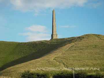
Fyfield - Pewsey's best nearby historic monuments can be found at Lansdowne Monument, Cherhill White Horse, and Avebury.
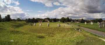
There are a several good ancient sites in the Fyfield - Pewsey area like Avebury, West Kennet Long Barrow, The Sanctuary, Silbury Hill, and Barbury Castle.
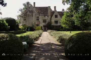
There are a several good historic buildings in the area around Fyfield - Pewsey like Avebury Manor.
Coate Water Country Park, Barbury Castle Country Park, and Lydiard Park are great places to visit near Fyfield - Pewsey if you like country parks.
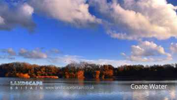
Coate Water is one of Fyfield - Pewsey's best, nearby lakes to visit in Fyfield - Pewsey.
Lydiard Park is a great place to visit close to Fyfield - Pewsey if you like parks.
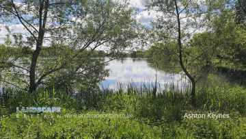
Ashton Keynes is one of Fyfield - Pewsey's best, nearby villages to visit in Fyfield - Pewsey.
Fyfield - Pewsey History
There are some historic monuments around Fyfield - Pewsey:
- Two earthwork enclosures and a linear earthwork 625m north of Barbury Castle
- South Street long barrow, 70m south east of the Long Stones
- Two bowl barrows 400m east of Cadley Vicarage
- West Kennet long barrow, 800m south-east of Silbury Hill
- Earthwork enclosure on Milk Hill
- The Sanctuary, Overton Hill
- Section of the Wansdyke
- Avebury Long Stones 380m east of The Grange Stables, Beckhampton
- Site of an oval stone circle and part of an adjacent field system 700m SW of West Kennet long barrow.
- Bowl barrow 200m south of Green Street and 1100m east of the Avebury henge monument, forming part of a round barrow cemetery on Avebury Down
- Two bowl barrows 670m south east of Beckhampton Buildings, forming part of a round barrow cemetery on Horton Down
- Knap Hill camp near Alton Priors
- Wick Down Farm earthwork
- Camp on Forest Hill
- Barbury Castle Farm deserted Medieval village
- Three bowl barrows 600m south-west of Knap Cottage
- Bowl barrow 70m north of Rockley Plantation
- Two bowl barrows 400m south of Tanhill Penning
- Bowl barrow forming part of a linear round barrow cemetery on Allington Down
- Pair of bowl barrows forming part of a round barrow cemetery on Allington Down
- Bowl barrow forming part of a linear round barrow cemetery on Allington Down
- Four earthwork enclosures on All Cannings Down
- Medieval settlement remains at Overtown
- Withy Copse ditch
- Horslip long barrow, 450m north-west of Horslip Bridge.
- Round barrow on Easton Down
- Enclosure on Ogbourne Down
- Winterbourne Bassett mound
- Bowl barrow 1km north-east of Avebury and 70m north of Green Street
- Earthwork enclosure and dewpond 490m north of Barbury Castle
- Disc barrow on Burderop Down, 1km north-east of Upper Herdswick Farm
- Settlement and field system on Milton Hill (Fyfield Down)
- Barbury Castle: a hillfort and bowl barrow
- Two saucer barrows and a pair of bowl barrows 750m SSW of Beckhampton Plantation, forming part of a round barrow cemetery on Horton Down
- Barrow on Smeathe's Ridge
- Adam's Grave: a long barrow on Walker's Hill
- Earthwork enclosure on Allington Down
- Bowl barrow 1km west of Tan Hill
- Bowl barrow 300m east of Ivy House Farm
- Bell barrow and adjacent bowl barrow on Marlborough Common, 120m east of Wootton Bassett Road
- The Hatfield Earthwork: a henge enclosure, henge and remains of monumental mound at Marden
- Village settlement on Barton Down
- Field system and earthwork enclosure on Burderop Down
- Linear earthwork in Savernake Forest, S of Great Lodge Bottom
- Martinsell Hill camp
- Bowl barrow 700m south-east of Windmill Hill
- Dam of King's fishpond
- Penning bell barrow 600m east of Avebury Down Barn
- Avebury henge and stone circles
- Grange Stables bell barrow
- Three sections of a linear earthwork south west of New Barn
- Bowl barrow 750m east of New Barn
- Disc barrow at Easton Clump
- Bell barrow 200m north of Rockley Plantation
- Group of six round barrows forming part of a Bronze Age cemetery 400m north-east of West Kennett Farm
- A causewayed enclosure, the core of a round barrow cemetery, part of a prehistoric field system and an associated mortuary enclosure on Windmill Hill
- Devil's Den long barrow, 600m east of White Acre
- Barrow on Coombe Down, 1070yds (980m) NE of Upper Poughcombe
- West Kennett Farm palisaded enclosures
- Long Stones long barrow 150m north of Beckhampton House
- Wansdyke: section 610yds (560m) NW of Wernham Farm to 250yds (230m) SW of New Buildings
- Bowl barrow 200m east of East Kennett long barrow forming part of a barrow cemetery
- Two bowl barrows 680m north of Upper Herdswick Farm, Barbury Down
- Group of barrows on Draycott Hill
- Three bell barrows and a pillow mound 400m south-west of Knap Cottage
- Bowl barrow 500m west of The Row
- Pair of round barrows 200m SSE of Windmill Hill: part of the Windmill Hill round barrow cemetery.
- Bowl barrow 800m north-east of Hackpen Barn
- Sharpridge earthworks
- Two round barrows W of New Town Farm
- Ogbourne Maizey Down round barrow
- Bowl barrow 900m south west of the junction of the Ridgeway and Green Street, forming part of a round barrow cemetery on Avebury Down
- Remains of `Falkner's Circle', a Neolithic stone circle 180m east of the West Kennet Avenue
- Bowl barrow 690m north of Rockley Manor: part of the Rockley Plantation barrow cemetery
- Mound in churchyard
- Saucer barrow: part of a barrow cemetery west of Barbury Castle
- Bowl barrow 275m west of Square Copse: part of the Square Copse barrow cemetery
- Bowl barrow 300m south-east of Walker's Plantation
- Bowl barrow 200m south of Windmill Hill: part of the Windmill Hill round barrow cemetery
- Bowl barrow 1450m south of Barbury Castle Farm
- Round barrow 750yds (690m) SE of Smeathe's Plantation
- Bowl barrow 800m south-east of Ogbourne St Andrew Farm
- Three Roman burial mounds, a Bronze Age bowl barrow, a pagan Saxon inhumation cemetery and a short length of Roman road on Overton Hill.
- Bowl barrow 400m south-east of Cadley Vicarage
- Iron Age enclosure on Overton Hill, 600m north west of North Farm
- Richardson medieval settlement
- Round barrow cemetery and part of a field system 200m south of Beckhampton Penning
- Bell barrow 75m west of Red Shore
- Two bowl barrows 820m north of Rockley Manor: part of the Rockley Plantation barrow cemetery
- Bowl barrow 200m north of East Kennett long barrow forming part of a cemetery
- Bowl barrow 900m SSE of Green Bank
- Bowl barrow 70m north of Green Street and east of the Avebury henge monument
- Three confluent round barrows 580m west of the Ridgeway, forming part of a Bronze Age round barrow cemetery on Avebury Down
- Earthwork enclosure N of Wansdyke
- Preshute Down field system
- Bowl barrow immediately west of the Ridgeway, 400m north east of its junction with Green Street
- Bowl barrow east of the Ridgeway forming part of the Overton Hill Bronze Age round barrow cemetery.
- Bell barrow 300m south-east of Avebury Down Barn forming part of a Bronze Age round barrow cemetery on Avebury Down
- Bowl barrow 200m east of Windmill Hill: part of the Windmill Hill round barrow cemetery.
- Linear barrow cemetery on Hackpen Hill
- Bowl barrow 400m south-east of Culley's Farm Cottages
- Beckhampton round barrow cemetery 150m north east of the `Waggon and Horses'
- Group of four round barrows 300m north west of the junction between the Ridgeway and Green Street on Avebury Down
- Barrow 350yds (320m) E of Smeathe's Plantation, Ogbourne Down
- Barrow S of Wansdyke
- Swanborough Tump
- Liddington Castle
- Bowl barrow 750m south-east of Windmill Hill
- Earthworks on Marlborough Common
- Linear boundary earthwork west of Liddington Castle
- Saucer barrow 250m east of Windmill Hill: part of the Windmill Hill round barrow cemetery
- Earthwork NW of New Town Farm
- Group of round barrows on Rough Hill
- Group of five round barrows north-east of the Sanctuary: part of the Overton Hill round barrow cemetery.
- Six bowl barrows 560m north of New Barn: part of a barrow cemetery on Monkton Down
- Bowl barrow 50m north of Barrow Farm
- Bowl barrow 880m north east of Lower Upham Farm
- Bowl barrow 750m south-east of Barbury Castle Farm
- Bell barrow 660m south east of Beckhampton Buildings, forming part of a round barrow cemetery on Horton Down
- Bowl barrow and a saucer barrow 200m north of Rockley Plantation
- Bowl barrow 880m north of Rockley Manor: part of the Rockley Plantation barrow cemetery
- Pair of round barrows forming part of the Bronze Age round barrow cemetery 400m north-east of West Kennett Farm
- Grange bowl barrow 130m north west of The Grange Stables bell barrow, Beckhampton
- Bowl barrow 750m north of Rockley Manor: part of the Rockley Plantation barrow cemetery
- Bowl barrow 620m north of Rockley Manor: part of the Rockley Plantation barrow cemetery
- Rybury camp
- Bowl barrow 650m ESE of New Barn, between Avebury Down and Monkton Down
- Bowl barrow 40m north west of East Kennett long barrow forming part of a cemetery
- Bell barrow 350m south-west of Barbury Barn
- Bowl barrow 230m west of The Grange, Beckhampton
- Langdean stone circle
- Bowl barrow forming part of a Bronze Age cemetery 400m north-east of West Kennett Farm on Overton Hill
- Bowl barrow 750m south-west of Manor Farm: part of the Windmill Hill round barrow cemetery
- Barrow on Avebury Down, S of track from Avebury
- Round barrow cemetery 400m south of Avebury henge monument on Waden Hill
- Wansdyke: section from S of Furze Hill to Marlborough-Pewsey road
- Sharpridge field system
- Bowl barrow 175m west of Square Copse: part of the Square Copse barrow cemetery
- All Cannings Cross, an Early Iron Age settlement site
- Medieval village site
- Prehistoric to post-medieval settlement, cultivation, industrial and funerary remains on Fyfield, Overton and Manton Downs
- Bowl barrow 500m north-west of Berwick Bassett Clump
- Medieval settlement remains immediately west of The Vicarage
- West Kennet Avenue and an earthwork bank east of West Kennett Farm
- Bowl barrow in The Belt, 350m north east of Hill Barn
- Barrow on Coombe Down, 930yds (830m) WSW of St George's Church
- Pair of bowl barrows 150m north of the Wansdyke on All Cannings Down
- Bowl barrow 1km west of Sheppard's Farm Dairy
- Section of Wansdyke and associated monuments from east of The Firs to the eastern side of Tan Hill
- Bowl barrow 610m south east of Beckhampton Buildings, forming part of a round barrow cemetery on Horton Down
- Saucer barrow 620m north of New Barn: Part of a barrow cemetery on Monkton Down
- Earth Burgh (or Eorth Burh) NW of New Town Farm
- Bowl barrow 630m north east of Wick Bottom Barn
- Whitefield Hill ditch
- Bowl barrow 50m south-east of the `Sanctuary' forming part of the Overton Hill round barrow cemetery.
- Shrunken medieval village site E of Avebury Trusloe
- Bowl barrow 375m east of Wick Bottom Barn
- Linear round barrow cemetery 200m ENE of West Kennett long barrow
- West Kennet bell barrow, 160m north-west of West Kennet long barrow
- Long barrow in Barrow Copse
- Earthwork enclosure 950m SSE of Manor Farm
- Bowl barrow 950m SSW of Beckhampton Plantation, forming part of a round barrow cemetery on Horton Down
- Church Hill earthwork
- Bowl barrow 800m south-east of Barbury Barn
- Bowl barrow 800m south-east of Tanhill Penning
- Earthwork W of New Town Farm
- Three bowl barrows: part of a barrow cemetery west of Barbury Castle
- Bowl barrow forming part of a round barrow cemetery on Allington Down
- Harepit Way linear boundary
- Pair of round barrows 400m west of the Ridgeway, forming part of a round barrow cemetery situated on Avebury Down
- East Kennett long barrow, 600m south of East Kennett church
- Bell barrow forming part of a round barrow cemetery 400m north-east of West Kennett Farm on Overton Hill
- Section of Roman Road 560m north east of Beckhampton Buildings
- Bowl barrow 150m north of the Alton White Horse
- Stone circle
- Crowdown Clump earthwork (Godsbury)
- Bowl barrow 770m south west of the junction of the Ridgeway and Green Street, forming part of a round barrow cemetery on Avebury Down
- Easton Clump settlement
- Bowl barrow 50m south of The Sanctuary on Overton Hill, forming part of the Seven Barrow Hill round barrow cemetery
- 'Giant's Grave' long barrow on Milton Hill
- Bowl barrow 120m west of East Kennett long barrow forming part of a cemetery
- Silbury Hill: a monumental Neolithic mound west of the River Kennet and south of Avebury village
- Bincknoll Camp
- Giant's Grave (Martinsell Hill)
- Two enclosures on Winterbourne Down
- Group of four round barrows 500m south-east of Avebury Down Barn, forming part of a Bronze Age round barrow cemetery on Avebury Down
- Castle mound
- Green Bank bowl barrow, 230m east of the Avebury henge monument
- Bowl barrow 50m north east of East Kennett long barrow forming part of a cemetery
- Bowl barrow 870m ESE of New Barn on Monkton Down