Westhampnett
Westhampnett is a Town in the county of West Sussex.
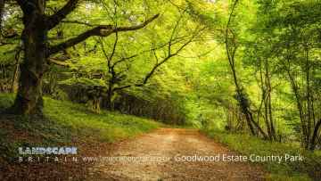
There are great places to visit near Westhampnett including some great towns, country parks, woodlands and airports.
There are a number of towns near Westhampnett including Chichester, and Crawley.
Westhampnett's best nearby country parks can be found at Goodwood Country Park, and Buchan Country Park.
The area around Westhampnett's best woodlands can be found at Goodwood Country Park.
Gatwick Airport, Shoreham Airport, and Chichester/Goodwood Airport are great places to visit near Westhampnett if you like airports.
Westhampnett History
There are some historic monuments around Westhampnett:
- Fishbourne Roman site
- Bowl barrow on Woolavington Down north-east of Stickingspit Bottom
- Hilltop enclosure and linear boundary on Bow Hill
- Boxgrove Priory
- Keep of Tote Copse castle, 400m north of Decoy Farmhouse
- Bowl barrow on Woolavington Down
- Medieval chapel near Chilgrove, 295m north-west of Yewtree Cottage
- Chichester Dyke, earthwork extending N 480yds (440m) from The Drive, Summersdale, near Chichester
- Romano-British villa, with cemetery and associated building, at Batten Hanger, 600m south east of Hill Lands Farm
- Chichester Dyke, earthwork extending N 360yds (330m) from Otter Memorial College
- Oval barrow, the north-western of two on Stoughton Down
- An Itford Hill style settlement in Kingley Vale
- Cross dyke on Woolavington Down, 475m north east of Tegleaze Farm
- Phoenix Caisson (inner) off Pagham
- Chichester Dyke, section of Broyle earthwork, extending 150yds (140m) through Plain Wood
- Ringwork south of St Wilfred's Chapel
- Two of three bowl barrows on Upwaltham Hill
- Bowl barrow and bell barrow on Graffham Down
- Flint mines on Bow Hill
- Seven sections of Stane Street Roman road between Eartham and Bignor, a prehistoric linear boundary and two bowl barrows
- Chichester Dyke, Broyle earthwork, section extending 360yds (330m) SW of Broyle House
- Two bowl barrows on Waltham Down, 115m east of crossroads: part of Waltham Down round barrow cemetery
- Oval barrow, the south-eastern of two on Stoughton Down
- Chichester Dyke, Broyle earthwork, section at Brandy Hole, extending E 230yds (210m) from railway, New Fishbourne
- Greyfriars Chapel, Priory Park
- Chichester Castle
- Market cross
- Bowl barrow in Selhurst Park
- A 210m length of Devil's Ditch running east from Chichester Main Road to Pook Lane
- Linear boundary 310m north west of the Tansley Stone on Bow Hill
- Bowl barrow on Cocking Down
- Chichester Dyke, Broyle earthwork, section extending 360yds (330m) S of West Broyle House
- Bowl barrow on Charlton Down, 350m south of Goodwood racecourse
- Flint mine on Stoke Down, immediately north of Stoke Clump
- Field system in Lamb Lea
- Chichester Dyke, Broyle earthwork, section extending 430yds (393m) through East Broyle Copse, to railway, and earthwork extending 400yds (365m) from Brandy Hole Lane, New Fishbourne
- Heyshott Down round barrow cemetery and cross dykes
- Bowl barrow in Stonehill Clump, Goodwood Country Park
- Beckett's Barn and adjoining earthworks
- Devil's Ditch, section extending 380yds (350m) NW from The Cottage, Goodwood Park
- Chichester Dyke, earthwork extending 250yds (230m) in Densworth Copse
- Chichester Dyke, earthwork extending 300yds (270m) W of Densworth House
- Halnaker House: a fortified medieval manor house and part of its landscaped grounds
- Devil's Ditch, section extending 960yds (870m) S of Lavant House
- Neolithic causewayed enclosure and associated remains on Court Hill
- The Devil's Jumps round barrow cemetery
- Devil's Ditch, section extending 200yds (180m) E of Waterbeach Hotel, Goodwood Park
- Devil's Ditch, section extending 1100yds (1000m), Valdoe Wood
- Bowl barrow on Bepton Down
- Chichester Dyke, sections in Little Cotfield Plantation
- Bexley Bushes earthworks
- Devil's Ditch, section extending 330yds (300m) W of Waterbeach Hotel, Goodwood Park, Box Grove
- A 362m length of Devil's Ditch running WNW from Chapel Lane
- Bowl barrow in Poyntz's Piece, Heyshott Down
- Two bowl barrows on Bow Hill forming part of The Devil's Humps round barrow cemetery
- One of three bowl barrows on Upwaltham Hill
- Linear boundary on Stoke Down, 800m north of West Stoke House
- Iron Age farmstead and Roman villa, 360m SSW of Brickkiln Farm
- Devil's Ditch, section extending 1200yds (1100m) through Little Tomlins Copse
- Causewayed enclosure, World War II searchlight emplacements and associated remains on Halnaker Hill
- Roman villa on Warren Down
- Long Down prehistoric flint mine
- Cross dyke on Woolavington Down, 625m east of Tegleaze Farm
- Medieval settlement in Eastdean Park, 670m north east of Counter's Gate
- Bowl barrow on Charlton Down, 250m south of Goodwood racecourse
- Double cross dyke on Upwaltham Hill
- Cross dyke on north eastern spur of Bow Hill, 150m south east of the Tansley Stone
- Cross dyke on Upwaltham Hill, 500m and 620m south east of Upwaltham Farm
- Bowl barrow on Graffham Down, 200m south of Limekiln Bottom
- A saucer barrow and a bowl barrow on Bow Hill, 270m south east of the Tansley Stone
- Cross dyke on south eastern spur of Bow Hill, 900m south west of the Tansley Stone
- Cross dyke on northern spur of Bow Hill, 500m north east of the Tansley Stone
- Chichester Dyke: section 200yds (180m) long in Mouthey's Plantation, section 245yds (220m) long in Oakwood and section 100yds (90m) long SW of Oakwood House
- Cross dyke on St Roche's Hill, 410m and 425m north east of The Trundle hillfort
- Cross dyke on St Roche's Hill, 480m north west of The Trundle hillfort
- Chichester Dyke, earthwork E of Chichester Barracks extending 600yds (550m)
- Chichester City Walls, The Tower, Orchard Street
- Two bell barrows, two pond barrows and a cross dyke on Bow Hill: part of The Devil's Humps round barrow cemetery
- Devil's Ditch, section extending 900yds (820m), Lye Wood, West Stoke
- Platform barrow on Bepton Down
- St Martin's Lane, Little London car park, Roman site
- Devil's Ditch, section extending 530yds (480m) W from Lavant Lodge
- Chichester Dyke, earthwork extending 110yds (100m) in Raughmere Copse
- Cross dyke on Heathbarn Down, 520m south east of Lodge Hill Farm
- The Trundle hillfort, causewayed enclosure and associated remains at St Roche's Hill
- Cross dyke on Woolavington Down, 600m south of Lavington House
- Bowl barrow on Bow Hill, 290m south east of the Tansley Stone
- Devil's Ditch, section extending 1730yds (1580m) from Stane Street to NW end of Redvin's Copse
- Multiple cross dyke on Little Graffham Bottom, 770m SSW of Hayland Farm
- Devil's Ditch, section extending 200yds (180m) E from Chapel Lane
- Bell barrow south-west of Heath Hanger: part of Waltham Down round barrow cemetery
- Prehistoric linear boundary at Crown Tegleaze, 1km north west of Littleton Farm
- Devil's Ditch, section 725yds (660m) long W of Ounces Barn
- Bowl barrow on Waltham Down, 200m east of cross roads: part of Waltham Down round barrow cemetery
- Roman amphitheatre
- Bowl barrow on Waltham Down, 320 ESE of crossroads: part of Waltham Down round barrow cemetery
- A deserted medieval village and post-medieval farm buildings, 1.4km north-west of Yew Tree Cottage
- A multiple enclosure fort known as Goosehill Camp and a prehistoric linear boundary on Bow Hill
- Bowl barrow on Graffham Down
- Bell barrow north-west of Brooms Farm
- Multiple cross dyke on Heyshott Down