Wepham
Wepham is a Village in the county of West Sussex.
There are great places to visit near Wepham including some great towns, country parks, woodlands and airports.
Chichester, and Crawley are great places to visit near Wepham if you like towns.
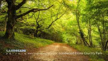
Wepham has some unmissable country parks nearby like Goodwood Country Park, and Buchan Country Park.
Wepham is near some unmissable woodlands like Goodwood Country Park,
Wepham has some unmissable airports nearby like Gatwick Airport, Shoreham Airport, and Chichester/Goodwood Airport.
Wepham History
There are some historic monuments around Wepham:
- Prehistoric flint mine and a Martin Down style enclosure on Harrow hill, 850m south east of Lee Farm
- Two bowl barrows south of Westburton Hill: part of Westburton Hill round barrow cemetery
- Flint mine and part of a cross dyke 300m south east of Tolmare Farm
- Group of four bowl barrows at the Chantry Post
- Bignor Roman Villa, 450m east of Manor Farm
- Bowl barrow 260m east of Trinity Methodist Church, forming part of a round barrow cemetery on Sullington Warren
- Two bowl barrows south of Westburton Hill: part of Westburton Hill round barrow cemetery
- Bowl barrow reused as moot mound in Barkhale Wood
- Flint mine and a bowl barrow on Church Hill, 400m south west of Findon Place
- Cross dyke on Sullington Hill, 500m south east of The Chantry
- Bowl barrow 120m SE of Trinity Methodist Church, forming part of a round barrow cemetery on Sullington Warren
- Cross dyke 330m north west of Whiteways Lodge
- Linear group of three bowl barrows immediately east of Kithurst Hill car park: part of a dispersed round barrow cemetery on Kithurst Hill
- Round barrow cemetery in Rackham Plantation
- Cross dyke on Springhead Hill, 780m south of Springhead Farm
- Bowl barrow 240m east of Trinity Methodist Church, forming part of a round barrow cemetery on Sullington Warren
- Barkhale Camp causewayed enclosure
- Roman barrow at Broomershill, 200m south east of Brocks Rew Farm
- Hardham Priory
- Lower Fittleworth North Bridge
- Motte and bailey castle in Pulborough Park
- Dalesdown Wood earthworks
- Deserted medieval settlement at Lower Barpham Farm
- Bowl barrow 915m WSW of Bignor Hill
- Highdown Hill Camp: A Ram's Hill type enclosure, an Anglo-Saxon cemetery and associated remains
- Stopham Bridge
- Itford Hill style settlement and an Anglo-Saxon barrow field at New Barn Down, 850m north west of Myrtle Grove Farm
- Coultershaw beam pump
- Old Swan Bridge, Pulborough
- Maison Dieu
- Lickfold Roman Bath House, Wiggonholt
- Arundel Castle
- Pair of bowl barrows 280m SE of Trinity Methodist Church, forming part of a round barrow cemetery on Sullington Warren
- Greatham Bridge
- Romano-British villa and traces of Iron Age occupation 500m WSW of New Barn
- Bowl barrow south of Westburton Hill: part of Westburton Hill round barrow cemetery
- Pair of bowl barrows on Amberley Mount, 760m north east of Downs Farm
- Amberley Castle
- Roman mansio and settlement, 535m north-east of Penn House
- Madehurst Wood earthworks
- Bowl barrow on Springhead Hill, 750m SSW of Springhead Farm
- Lime kilns, canal, engine sheds, etcetera
- Settlement site in Chantry Bottom
- Medieval moated site off Moat Lane
- Group of six bowl barrows 790m south west of Grey Friars Farm: part of a dispersed round barrow cemetery on Kithurst Hill
- Lower Fittleworth South Bridge
- Bowl barrow at Kithurst Hill car park: part of a dispersed round barrow cemetery on Kithurst Hill
- Bowl barrow on Sutton Common, 50m south-west of the Old School House
- Bowl barrow 780m south-west of Bignor Hill
- Prehistoric flint mine and part of a round barrow cemetery at Blackpatch, 400m north east of Myrtle Grove Farm
- Muntham Court Romano-British site
- Two bowl barrows south-east of Egg Bottom Coppice
- Bowl barrow 800m south-west of Bignor Hill
- The Mill Ball: a bowl barrow south of Bury Hill
- War Dyke entrenchment in Whiteways Plantation and South Wood
- Rackham Banks: A cross dyke and Itford Hill style settlement on Rackham Hill, 900m SSE of Oldbottom Barn
- The Burgh: a bowl barrow 940m east of Canada
- Cross dyke on Barpham Hill, 600m north west of Lower Barpham
- Bowl barrow 200m SE of Trinity Methodist Church, forming part of a round barrow cemetery on Sullington Warren
- Itford Hill style settlement on Cock Hill
- Medieval earthworks E and SE of St Mary's Church
- Lynchets N of Downs Farm
- A 19th century artillery fort known as Littlehampton Fort, 317m south west of the Windmill Theatre
- Bowl barrow on Sutton Common, 600m NNW of Newoods Farm
- Ringwork 400m NNW of Batworthpark House
- Bowl barrow on Westburton Hill
- Deserted medieval settlement at Upper Barpham Farm
- Bowl barrow on Sutton Common, 120m south west of the Old School House
- Bowl barrow 950m south west of Grey Friars Farm: part of a dispersed round barrow cemetery on Kithurst Hill
- Cross dyke on Chantry Hill, 470m south of Grey Friars Farm
- Prehistoric linear boundary on Wepham Down
- Group of three bowl barrows 350m SE of Trinity Methodist Church, forming part of a round barrow cemetery on Sullington Warren
- Goblestubbs Copse earthworks
- Bowl barrow 960m WSW of Bignor Hill
- An unenclosed Iron Age urnfield and associated remains on Rackham Hill, 900m SSE of Rackham Farm
- Bowl barrow 230m NE of Trinity Methodist Church, forming part of a round barrow cemetery on Sullington Warren
- Tortington Augustinian priory and ponds, including part of priory precinct
- Bowl barrow on Sutton Common, 200m south of The Bung
- Bowl barrow on Wiggonholt Common, 290m south of Upperton's Barn
- Pair of platform barrows on the western side of Kithurst Hill car park: part of a dispersed round barrow cemetery on Kithurst Hill
- Burpham camp