Walderton
Walderton is a Village in the county of West Sussex.
Walderton postcode: PO18 9EF
There are great places to visit near Walderton including some great towns, country parks, woodlands and airports.
There are a several good towns in the Walderton area like Chichester, and Crawley.
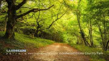
There are a several good country parks in the Walderton area like Goodwood Country Park, and Buchan Country Park.
Places near Walderton feature a number of interesting woodlands including Goodwood Country Park.
Walderton has some unmissable airports nearby like Gatwick Airport, Shoreham Airport, and Chichester/Goodwood Airport.
Walderton History
There are some historic monuments around Walderton:
- Torberry hillfort
- Chichester Dyke, Broyle earthwork, section extending 360yds (330m) SW of Broyle House
- Chichester Dyke, earthwork extending 250yds (230m) in Densworth Copse
- Chichester Dyke, section of Broyle earthwork, extending 150yds (140m) through Plain Wood
- Harting Beacon: a hilltop enclosure, Anglo-Saxon burial mound and telegraph station on Beacon and Pen Hills
- Bowl barrow on Fitzhall Rough, 330m ENE of Fitzhall: part of Fitzhall Rough round barrow cemetery
- A hilltop enclosed by Iron Age cross dykes, an associated field system and Bronze Age barrows at Butser Hill
- Chichester Dyke, sections in Little Cotfield Plantation
- Roman villa on Warren Down
- Anglo-Saxon cemetery at Chalton Peak
- A 210m length of Devil's Ditch running east from Chichester Main Road to Pook Lane
- Chichester Dyke, Broyle earthwork, section extending 360yds (330m) S of West Broyle House
- Ruined church
- Iron Age farmstead and Roman villa, 360m SSW of Brickkiln Farm
- Ringwork and bailey at Motleys Copse
- A 362m length of Devil's Ditch running WNW from Chapel Lane
- Three bowl barrows on Fitzhall Rough, 200m north-east of Fitzhall: part of Fitzhall Rough round barrow cemetery
- Three bowl barrows 500m NNE of Fitzhall: part of Fitzhall Heath round barrow cemetery
- Romano-British villa and traces of medieval occupation at Pitlands Farm, Up Marden
- Warblington Castle
- Bell barrow north-west of Brooms Farm
- Cross dyke on northern spur of Bow Hill, 500m north east of the Tansley Stone
- Cross dyke on Heathbarn Down, 520m south east of Lodge Hill Farm
- Bowl barrow 480m south of Irongates Lodge
- Bowl barrow 250m north-west of Fitzhall Lodge: part of Fitzhall Heath round barrow cemetery
- Cross dyke on north eastern spur of Bow Hill, 150m south east of the Tansley Stone
- Hilltop enclosure and linear boundary on Bow Hill
- Bevis's Thumb long barrow, 370m west of Fernbeds Farm
- Bowl barrow on Bepton Down
- Bowl barrow 180m north east of Foxcombe House
- Linear boundary 310m north west of the Tansley Stone on Bow Hill
- Medieval chapel near Chilgrove, 295m north-west of Yewtree Cottage
- Chichester Dyke, Broyle earthwork, section extending 430yds (393m) through East Broyle Copse, to railway, and earthwork extending 400yds (365m) from Brandy Hole Lane, New Fishbourne
- The Vandalian Tower, Up Park
- Bowl barrow on Didling Hill
- Oval barrow, the south-eastern of two on Stoughton Down
- Cross dyke on south eastern spur of Bow Hill, 900m south west of the Tansley Stone
- Platform barrow on Bepton Down
- A deserted medieval village and post-medieval farm buildings, 1.4km north-west of Yew Tree Cottage
- The Devil's Jumps round barrow cemetery
- Chichester Dyke, earthwork extending 110yds (100m) in Raughmere Copse
- Fishbourne Roman site
- Motte castle at Motley's Copse
- Three bowl barrows on Chalton Down, 860m east of Netherley Farm
- Linear boundary on Stoke Down, 800m north of West Stoke House
- Two round barrows in Grevitts Copse
- Flint mines on Bow Hill
- Chichester Dyke: section 200yds (180m) long in Mouthey's Plantation, section 245yds (220m) long in Oakwood and section 100yds (90m) long SW of Oakwood House
- A Romano-Celtic temple, Iron Age shrine and associated remains 250m north west of Ratham Mill
- Black Barn, Warblington
- Bowl barrow on Goldrings Warren
- Devil's Ditch, section extending 1200yds (1100m) through Little Tomlins Copse
- Oval barrow, the north-western of two on Stoughton Down
- Romano-British villa, with cemetery and associated building, at Batten Hanger, 600m south east of Hill Lands Farm
- Bowl barrow on Chalton Down, 350m south east of Manor Farm
- Twin bell barrow and a bowl barrow on Asdean Down
- A saucer barrow and a bowl barrow on Bow Hill, 270m south east of the Tansley Stone
- Bowl barrow north west of Telegraph House
- Bowl barrow on Trotton Common, 500m south of Trotton Nurseries
- Cross dyke on West Harting Down, 650m south west of Foxcombe Farm
- Flint mine on Stoke Down, immediately north of Stoke Clump
- Bowl barrow 520m north of Fitzhall: part of Fitzhall Heath round barrow cemetery
- Multiple cross dyke on Harting Downs, 570m east of Down Place
- Romano-British and Iron Age buildings, field system and hollow ways in the southern part of Holt Down Plantation
- Chichester Dyke, Broyle earthwork, section at Brandy Hole, extending E 230yds (210m) from railway, New Fishbourne
- Bowl barrow 220m WNW of Fitzhall Lodge: part of Fitzhall Heath round barrow cemetery
- Two bowl barrows on Iping Common, 520m SSW of Crossways Cottages
- Romano-British village
- Devil's Ditch, section extending 900yds (820m), Lye Wood, West Stoke
- Devil's Ditch, section extending 960yds (870m) S of Lavant House
- Tourner Bury, Hayling Island, South Hayling
- Bowl barrow 280m WNW of Fitzhall Lodge: part of Fitzhall Heath round barrow cemetery
- Bowl barrow on Bow Hill, 290m south east of the Tansley Stone
- Bowl barrow on Treyford Hill
- Oval barrow 700m SSE of Locksash Farm
- An Itford Hill style settlement in Kingley Vale
- A multiple enclosure fort known as Goosehill Camp and a prehistoric linear boundary on Bow Hill
- Chichester Dyke, earthwork extending 300yds (270m) W of Densworth House
- Two bowl barrows on Bow Hill forming part of The Devil's Humps round barrow cemetery
- Bowl barrow in Edgar Plantation
- Devil's Ditch, section extending 200yds (180m) E from Chapel Lane
- Two bell barrows, two pond barrows and a cross dyke on Bow Hill: part of The Devil's Humps round barrow cemetery
- The Castle
- Bowl barrow on Linch Down