Oving
Oving is a Village in the county of West Sussex.
Oving postcode: PO20 2DE
There are great places to visit near Oving including some great towns, country parks, woodlands and airports.
The area around Oving features a number of interesting towns including Chichester, and Crawley.
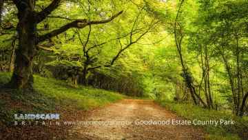
Goodwood Country Park, and Buchan Country Park are some of Oving best country parks to visit near Oving.
There are a number of woodlands near to Oving including Goodwood Country Park.
Oving's best nearby airports can be found at Gatwick Airport, Shoreham Airport, and Chichester/Goodwood Airport.
Oving History
There are some historic monuments around Oving:
- Devil's Ditch, section extending 200yds (180m) E from Chapel Lane
- Chichester Dyke, section of Broyle earthwork, extending 150yds (140m) through Plain Wood
- Devil's Ditch, section extending 960yds (870m) S of Lavant House
- Cross dyke on St Roche's Hill, 480m north west of The Trundle hillfort
- Prehistoric linear boundary at Crown Tegleaze, 1km north west of Littleton Farm
- Roman villa on Warren Down
- Chichester Dyke, earthwork extending N 480yds (440m) from The Drive, Summersdale, near Chichester
- Chichester Dyke, Broyle earthwork, section extending 430yds (393m) through East Broyle Copse, to railway, and earthwork extending 400yds (365m) from Brandy Hole Lane, New Fishbourne
- Boxgrove Priory
- Market cross
- Medieval chapel near Chilgrove, 295m north-west of Yewtree Cottage
- Devil's Ditch, section 725yds (660m) long W of Ounces Barn
- Bowl barrow on Woolavington Down north-east of Stickingspit Bottom
- Bexley Bushes earthworks
- Bowl barrow on Waltham Down, 200m east of cross roads: part of Waltham Down round barrow cemetery
- Roman amphitheatre
- Chichester Dyke, Broyle earthwork, section extending 360yds (330m) S of West Broyle House
- Devil's Ditch, section extending 530yds (480m) W from Lavant Lodge
- Cross ridge dykes on Sutton Down
- The Trundle hillfort, causewayed enclosure and associated remains at St Roche's Hill
- Chichester Dyke, Broyle earthwork, section extending 360yds (330m) SW of Broyle House
- Cross dyke on Woolavington Down, 625m east of Tegleaze Farm
- Flint mine on Stoke Down, immediately north of Stoke Clump
- Long Down prehistoric flint mine
- Cross dyke on St Roche's Hill, 410m and 425m north east of The Trundle hillfort
- Cross dyke on Heathbarn Down, 520m south east of Lodge Hill Farm
- Cross dyke 180m north of radio masts at Glatting Beacon
- Bowl barrow on Charlton Down, 350m south of Goodwood racecourse
- A 362m length of Devil's Ditch running WNW from Chapel Lane
- Chichester Dyke, Broyle earthwork, section at Brandy Hole, extending E 230yds (210m) from railway, New Fishbourne
- Seven sections of Stane Street Roman road between Eartham and Bignor, a prehistoric linear boundary and two bowl barrows
- Chichester Dyke, earthwork extending 250yds (230m) in Densworth Copse
- Bowl barrow 430m north east of Gumber Farm
- Devil's Ditch, section extending 330yds (300m) W of Waterbeach Hotel, Goodwood Park, Box Grove
- Bowl barrow on Charlton Down, 250m south of Goodwood racecourse
- A multiple enclosure fort known as Goosehill Camp and a prehistoric linear boundary on Bow Hill
- Bowl barrow on Waltham Down, 320 ESE of crossroads: part of Waltham Down round barrow cemetery
- Bowl barrow on Barlavington Down
- Halnaker House: a fortified medieval manor house and part of its landscaped grounds
- Prehistoric linear boundary on Barlavington Down, 550m north east of Dog Kennels
- Cross dyke on Woolavington Down, 600m south of Lavington House
- Two of three bowl barrows on Upwaltham Hill
- Bowl barrow on Glatting Beacon
- A 210m length of Devil's Ditch running east from Chichester Main Road to Pook Lane
- Chichester Dyke, earthwork extending 110yds (100m) in Raughmere Copse
- Chichester Dyke, sections in Little Cotfield Plantation
- Round barrow S of Burton Down
- Neolithic causewayed enclosure and associated remains on Court Hill
- Denture bowl barrow
- Ringwork south of St Wilfred's Chapel
- St Martin's Lane, Little London car park, Roman site
- Field system in Lamb Lea
- Devil's Ditch, section extending 1200yds (1100m) through Little Tomlins Copse
- Causewayed enclosure, World War II searchlight emplacements and associated remains on Halnaker Hill
- Bowl barrow in Stonehill Clump, Goodwood Country Park
- Devil's Ditch, section extending 1100yds (1000m), Valdoe Wood
- Medieval settlement in Eastdean Park, 670m north east of Counter's Gate
- Phoenix Caisson (inner) off Pagham
- Chichester Castle
- Bell barrow south-west of Heath Hanger: part of Waltham Down round barrow cemetery
- Fishbourne Roman site
- Devil's Ditch, section extending 1730yds (1580m) from Stane Street to NW end of Redvin's Copse
- Greyfriars Chapel, Priory Park
- Cross dyke on Woolavington Down, 475m north east of Tegleaze Farm
- Beckett's Barn and adjoining earthworks
- Two bowl barrows on Waltham Down, 115m east of crossroads: part of Waltham Down round barrow cemetery
- Bowl barrow on Woolavington Down
- Chichester Dyke, earthwork E of Chichester Barracks extending 600yds (550m)
- Iron Age farmstead and Roman villa, 360m SSW of Brickkiln Farm
- Chichester City Walls, The Tower, Orchard Street
- Bowl barrow in Selhurst Park
- One of three bowl barrows on Upwaltham Hill
- Double cross dyke on Upwaltham Hill
- Chichester Dyke, earthwork extending N 360yds (330m) from Otter Memorial College
- Keep of Tote Copse castle, 400m north of Decoy Farmhouse
- Devil's Ditch, section extending 380yds (350m) NW from The Cottage, Goodwood Park
- Devil's Ditch, section extending 200yds (180m) E of Waterbeach Hotel, Goodwood Park
- Cross dyke on Upwaltham Hill, 500m and 620m south east of Upwaltham Farm
- Phoenix Caisson (outer) off Pagham Harbour