Graffham
Graffham is a Town in the county of West Sussex.
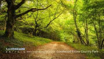
There are great places to visit near Graffham including some great towns, country parks, woodlands and airports.
Chichester, and Crawley are great places to visit near Graffham if you like towns.
Goodwood Country Park, and Buchan Country Park are great places to visit near Graffham if you like country parks.
The area close to Graffham boasts some of the best woodlands including Goodwood Country Park.
Gatwick Airport, Shoreham Airport, and Chichester/Goodwood Airport are some of Graffham best airports to visit near Graffham.
Graffham History
There are some historic monuments around Graffham:
- Bowl barrow on Waltham Down, 320 ESE of crossroads: part of Waltham Down round barrow cemetery
- Two bowl barrows on Gallows Hill, 200m east of Millborough House
- Two bowl barrows south of Westburton Hill: part of Westburton Hill round barrow cemetery
- Heyshott Down round barrow cemetery and cross dykes
- Devil's Ditch, section extending 530yds (480m) W from Lavant Lodge
- Bell barrow south-west of Heath Hanger: part of Waltham Down round barrow cemetery
- Devil's Ditch, section extending 330yds (300m) W of Waterbeach Hotel, Goodwood Park, Box Grove
- Devil's Ditch, section extending 200yds (180m) E of Waterbeach Hotel, Goodwood Park
- Double cross dyke on Upwaltham Hill
- Little Bury bowl barrow
- Great Bury bowl barrow
- Barkhale Camp causewayed enclosure
- Bowl barrow 780m south-west of Bignor Hill
- Bowl barrow 100m south of Barnett's Farm
- Bowl barrow reused as moot mound in Barkhale Wood
- Bowl barrow on Westburton Hill
- Bowl barrow 800m south-west of Bignor Hill
- Neolithic causewayed enclosure and associated remains on Court Hill
- Duncton Common round barrow cemetery
- Bowl barrow 960m WSW of Bignor Hill
- Woolbeding Bridge
- Long Down prehistoric flint mine
- Multiple cross dyke on Little Graffham Bottom, 770m SSW of Hayland Farm
- Madehurst Wood earthworks
- Round barrow S of Burton Down
- Bowl barrow on Graffham Down
- Devil's Ditch, section extending 1730yds (1580m) from Stane Street to NW end of Redvin's Copse
- Bowl barrow on Woolavington Down
- Bowl barrow on Cocking Down
- Bowl barrow 350m WNW of Barnett's Bridge
- Bowl barrow 430m north east of Gumber Farm
- Bowl barrow on Heyshott Common, 170m west of Upper Polecats Copse
- Bowl barrow in Stonehill Clump, Goodwood Country Park
- Bowl barrow on Gallows Hill, 300m east of Millborough House
- Cross dyke on Woolavington Down, 600m south of Lavington House
- Bowl barrow 915m WSW of Bignor Hill
- Bowl barrow on Lavington Common, 500m north-west of Westerland Lodge
- Dalesdown Wood earthworks
- Bowl barrow on Sutton Common, 200m south of The Bung
- Devil's Ditch, section extending 1100yds (1000m), Valdoe Wood
- Bowl barrow on Lavington Common, 540m east of Main Wood Cottage
- Multiple cross dyke on Heyshott Down
- Romano-British settlement at Church Farm
- Bowl barrow south of Burton Rough
- Brick and tile works on Ebernoe Common, 592m SSW of Mill House
- Bowl barrow on Lavington Common, 150m SSE of Main Wood Cottage
- Two bowl barrows on Waltham Down, 115m east of crossroads: part of Waltham Down round barrow cemetery
- Cross dyke on Woolavington Down, 625m east of Tegleaze Farm
- Bexley Bushes earthworks
- Bowl barrow on Sutton Common, 600m NNW of Newoods Farm
- Bowl barrow and bell barrow on Graffham Down
- Bowl barrow on Heyshott Common, 250m west of Foundry Cottages
- One of three bowl barrows on Upwaltham Hill
- Goblestubbs Copse earthworks
- Devil's Ditch, section extending 380yds (350m) NW from The Cottage, Goodwood Park
- Cross dyke on St Roche's Hill, 480m north west of The Trundle hillfort
- Bowl barrow 100m SSW of Barnett's Farm
- Bowl barrow on Woolavington Down north-east of Stickingspit Bottom
- Bowl barrow on Sutton Common, 120m south west of the Old School House
- Medieval settlement in Eastdean Park, 670m north east of Counter's Gate
- Bowl barrow in Walkers Copse, Heyshott Common
- Two bowl barrows south of Westburton Hill: part of Westburton Hill round barrow cemetery
- Two of three bowl barrows on Upwaltham Hill
- Cross dyke on Upwaltham Hill, 500m and 620m south east of Upwaltham Farm
- Bowl barrow on Waltham Down, 200m east of cross roads: part of Waltham Down round barrow cemetery
- Bowl barrow on Sutton Common, 50m south-west of the Old School House
- North Park Furnace: iron works and gun foundry
- Cross dyke on Woolavington Down, 475m north east of Tegleaze Farm
- Bignor Roman Villa, 450m east of Manor Farm
- Cross ridge dykes on Sutton Down
- Bowl barrow in Starve Acre Copse, 200m east of Heather View
- Field system in Lamb Lea
- Bowl barrow in Selhurst Park
- Cross dyke 180m north of radio masts at Glatting Beacon
- Two bowl barrows south-east of Egg Bottom Coppice
- Bowl barrow on Charlton Down, 350m south of Goodwood racecourse
- Boxgrove Priory
- Coultershaw beam pump
- Bowl barrow in Poyntz's Piece, Heyshott Down
- Medieval moated site north-east of Upper Common
- Prehistoric linear boundary at Crown Tegleaze, 1km north west of Littleton Farm
- Bowl barrow in Starve Acre Copse, 290m east of Heather View
- Prehistoric linear boundary on Barlavington Down, 550m north east of Dog Kennels
- Bowl barrow on Lavington Common, 130m SSW of Main Wood Cottage
- Bowl barrow on Lavington Common, 550m north of Westerland Stud
- Bowl barrow on Graffham Down, 200m south of Limekiln Bottom
- Halnaker House: a fortified medieval manor house and part of its landscaped grounds
- Motte castle south of Lodsbridge Mill
- Bowl barrow 500m WNW of Barnett's Bridge
- Denture bowl barrow
- Four bowl barrows on Lavington Common, north of Lower Barn
- Bowl barrow on Gallows Hill, 150m east of Millborough House
- Seven sections of Stane Street Roman road between Eartham and Bignor, a prehistoric linear boundary and two bowl barrows
- Bowl barrow on Charlton Down, 250m south of Goodwood racecourse
- Devil's Ditch, section 725yds (660m) long W of Ounces Barn
- Causewayed enclosure, World War II searchlight emplacements and associated remains on Halnaker Hill
- Bowl barrow on Glatting Beacon
- Cross dyke on St Roche's Hill, 410m and 425m north east of The Trundle hillfort
- Cowdray: a fortified medieval house and part of its landscaped grounds
- Bowl barrow on Barlavington Down
- Motte and bailey castle on St Ann's Hill, Midhurst
- Bowl barrow south of Westburton Hill: part of Westburton Hill round barrow cemetery
- The Trundle hillfort, causewayed enclosure and associated remains at St Roche's Hill