


Playford
Playford is a Village in the county of Suffolk.
There are great places to visit near Playford including some great fens, nature reserves, historic buildings, villages and historic monuments.
The area close to Playford boasts some of the best fens including Lopham Fen.
Nature Reserves to visit near Playford include Lopham Fen.
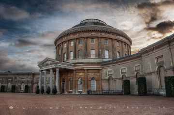
The area around Playford's best historic buildings can be found at Ickworth.
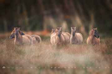
There are a several good villages in the area around Playford like Elveden.
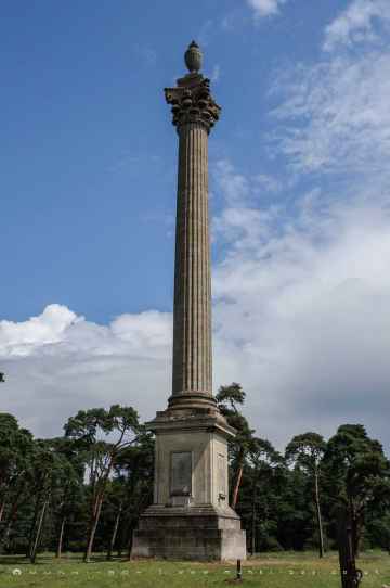
The area close to Playford boasts some of the best historic monuments including Elveden Monument.
Playford History
There are some historic monuments around Playford:
- Area of Middle and Late Saxon town, off Greyfriars Road
- Bowl barrow 750m south west of Redhouse Farm: part of a barrow cemetery on Levington Heath
- Moated site at Redhouse Farm
- Moated site at The Old Rectory
- Moated site S of Basting's Hall
- Bowl barrow 580m north of Dobbs Corner
- Area of middle and late Saxon town, off Star Lane
- Moated site at Hoo Green, 290m north west of Godwin's Place
- Moated site at Abbey Farm
- Bowl barrow on Playford Heath, 625m south of Lux Farm
- Two bowl barrows 312m south west of Dobbs Corner
- Bowl barrow 680m north of Dobbs Corner
- Two bowl barrows in Hobbin's Belt, 820m south-east of White House Farm: part of Seven Hills barrow cemetery
- Bowl barrow north of Hobbin's Belt, 900m south-east of White House Farm: part of Seven Hills barrow cemetery
- Letheringham Priory and remains of 17th century walled garden
- Bowl barrow on Playford Heath, 870m south of Lux Farm
- Bowl barrow and pill box 450m north west of Sheep Drift Farm
- Bowl barrow in Birch Grove, Martlesham Heath
- Two bowl barrows in Knight's Wood, 460m south-east of White House Farm: part of Seven Hills barrow cemetery
- Bowl barrow in Hobbin's Belt, 850m south-east of White House Farm: part of Seven Hills barrow cemetery
- Area of middle and late Saxon town, and medieval defences, off Old Foundry Road
- Bowl barrow in Portal Avenue
- Playford Hall moated site
- Dominican friary (remains of), and a section of the east precinct wall
- Buried remains of Late Saxon and medieval town defences, and a section of C14 precinct wall to the Dominican friary of the Ipswich Blackfriars
- Bowl barrow at Seven Hills Cottages, 720m south-east of White House Farm: part of Seven Hills barrow cemetery
- Moated site at Folly Farm
- Settlement site around St Botolph's Church
- Moated site at Letheringham Lodge
- Moated site and ponds at Thistleton Hall
- Bowl barrow on Waldringfield Heath, 150m south of Heath Farm
- Bowl barrow 180m ENE of Sheep Drift Farm
- Bowl barrow 155m east of Sheep Drift Farm
- Bowl barrow 820m south west of Redhouse Farm: part of a barrow cemetery on Levington Heath
- Boot Street Bridge
- Pole Hill bowl barrow
- Bowl barrow 170m west of Kesgrave High School buildings
- Bowl barrow in Lancaster Drive, Martlesham Heath
- Two bowl barrows in Spratt's Plantation.
- Six bowl barrows in Knight's Wood, 500m south-east of White House Farm: part of Seven Hills barrow cemetery
- Motte castle known as The Mount, 440m south west of St Mary's Church
- Moated site 200m west of Otley Hall
- Moated site 1/2 mile (800m) SW of Moat Farm
- Interrupted ditch system at Potash Farm
- Moated site of Old Berghersh House
- Godwin's Place moated site and ponds
- Area of Middle and Late Saxon town between Upper Brook Street and Upper Orwell Street
- Bowl barrow 900m south west of Redhouse Farm: part of a barrow cemetery on Levington Heath
- Bowl barrow in Hobbin's Belt, 740m south-east of White House Farm: part of Seven Hills barrow cemetery
- Bowl barrow 980m south west of Redhouse Farm: part of a barrow cemetery on Levington Heath
- Three bowl barrows and a ring ditch, 700m south west of Redhouse Farm: part of a barrow cemetery on Levington Heath.
- Area of middle and late Saxon town between Turret Lane and Star Lane
- Bowl barrow 1200m south west of Redhouse Farm: part of a barrow cemetery on Levington Heath
- Wolsey's Gate, College Street
Places to see near Playford
Lakes near Playford
Rivers near Playford
- Lark - Fynn (d/s confluence)
- Shottisham Mill River
- Earl Soham Watercourse
- Lark
- Deben (u/s Brandeston Bridge)
- Byng Brook
- Deben (Brandeston Bridge - Melton)
- Bucklesham Mill River
- Fynn
- Potsford Brook
- Chediston Watercourse
- Hundred River
- Butley River
- Leiston Beck
- Fromus
- Easton Broad
- Alde
- Blyth (Huntingfield tributary)
- Black Ditch (East Suffolk)
- Wang
- Wenhaston Watercourse
- Lothingland Hundred
- Blyth (d/s Halesworth)
- Alde - Ore (d/s confluence)
- Minsmere Old River
- Blyth (u/s Halesworth)
- Blyth (Laxfield - Hevingham Hall)
- Ore
- Blyth (Hevingham Hall - d/s Halesworth)
- Blyth (New Reach through Halesworth)
- Tang
- Wattisham Watercourse
- Jordan (East Suffolk)
- Somersham Watercourse
- Rattlesden River (d/s Gt. Finborough)
- Gipping (u/s Stowmarket)
- Great Finborough Watercourse
- Gipping (d/s Stowmarket)
- Coddenham Watercourse
- Haughley Watercourse
- Gipping (through Stowmarket)
- Rattlesden River (u/s confluence with Gt. Finborough)
- Belstead Brook
- Spixworth ( and Dobbs) Beck
- Bure (Horstead Mill to St Benet's Abbey)
- East Ruston Stream
- Thurne
- North Walsham and Dilham Canal (disused)
- Mermaid Stream
- Bure (u/s confluence with Scarrow Beck)
- Smallburgh Watercourse
- Ant (Dilham to R. Bure)
- King's Beck
- Bure (Scarrow Beck to Horstead Mill)
- Scarrow Beck
- Muck Fleet
- Hevingham Watercourse
- New Cut
- Starston Brook
- Waveney (u/s Frenze Beck)
- Waveney (Ellingham Mill - Burgh St. Peter)
- Waveney (R Dove - Starston Brook)
- Waveney (Frenze Beck to Dove)
- Metfield Stream
- Dove trib - Finningham
- Dove
- Frenze Beck
- Waveney (Starston Brook - Ellingham Mill)
- Tributary of Upper Waveney
- Dove trib - Eye
- Broome Beck
- Chickering Beck
- Tributary of Waveney
- The Beck
- Mendlesham Stream
- Dickleburgh Stream
- Buckenham Stream
- Stow Bedon Stream
- Hopton Brook
- Little Ouse (Hopton Common to Sapiston Confl)
- Larling Brook
- Pakenham Stream
- Thelnetham Brook
- Little Ouse (Thelnetham to Hopton Common)
- Sapiston River
- Whittle
- Stowlangtoft Stream
- Stanton Tributary
- Little Ouse River
- Little Ouse (Sapiston Confluence to Nuns' Br)
- Thet (DS Swangey Fen)
- Sapiston
- Thet (US Swangey Fen)
- Little Ouse (US Thelnetham)
- Cut-off Channel
- Old West River
- Ely Ouse (South Level)
- Cavenham Stream
- Lark (Hawstead to Abbey Gardens)
- Lee Brook
- Lark downstream of Mill Street Bridge
- Lark (US Hawstead)
- Culford Stream
- Hawstead Tributary
- Kennett-Lee Brook
- Linnet
- Tuddenham Stream
- Kennett - Lee Brook
- Lark (Abbey Gardens to Mildenhall)
- Wrabness Brook
- Glem - Lower
- Chad Brook
- Glem - Upper
- Bumpstead Brook
- Brett
- Old River Brett
- Stour Brook
- Stour (u/s Wixoe)
- Lavenham Brook
- Stutton Brook
- Stour (d/s R. Brett)
- Chilton Brook
- Bildeston Brook
- Belchamp Brook
- Box
- Ramsey River
- Stour (Lamarsh - R. Brett)
- Stour (Wixoe - Lamarsh)
- Eastwood Brook
- Crouch (A129 - Wickford)
- Roach
- Crouch (d/s Wickford)
- Rettendon Brook
- Noblesgreen Ditch
- Crouch (Upper) - u/s A129
- Prittle Brook


