

Dungworth
Dungworth is a Village in the county of South Yorkshire.
Dungworth postcode: S6 6HE
There are great places to visit near Dungworth including some great towns, cities, shopping centres and airports.
Places near Dungworth feature a number of interesting towns including Wath-upon-Dearne.
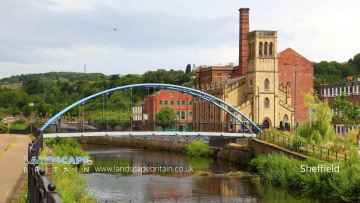
Dungworth has some unmissable cities nearby like Sheffield, and Doncaster.
Shopping Centres to visit near Dungworth include Meadowhall, and Frenchgate Centre.
Places near Dungworth feature a number of interesting airports including Doncaster Sheffield Airport.
Dungworth History
There are some historic monuments around Dungworth:
- Ewden Beck round barrow cemetery and cross-dyke
- Cairn on Bamford Moor, 960m north east of Clough House
- Beauchief Abbey Premonstratensian monastery: inner precinct and three fishponds
- Camp Green ringwork
- Two ring cairns at Ciceley Low, 500m ESE of Parson House Farm
- Cairnfield 970m north west of Green's House
- Padley Hall: a medieval great house
- Abbeydale Works
- Romano-British field system and settlement at Wheata Wood
- Prehistoric standing stone 1,030m south west of triangulation point on High Neb
- Cairnfield 600m NNE of High Lees Farm
- Medieval field system and long houses at Lawrence Field
- Iron Age and Roman quern workings on Wharncliffe Rocks
- Castle Hill motte and bailey castle, High Bradfield
- The Shepherd Wheel
- Callow prehistoric settlement and field system, Carr Head Moor, 300m ENE of Toothill Farm
- Embanked stone circle on Eyam Moor, 340m south of Leam Hall Farm
- Cairnfield on Broomhead Moor, 500m north west of Mortimer House
- Redmires First World War Training Area
- Wayside cross on Bradfield Moor known as New Cross
- Cowell Flat prehistoric field system, 350m south east of Mortimer House
- Water powered bloomery, iron forge and rolling mill at Low Forge
- Sheepwash Bank and Dennis Knoll prehistoric settlement and field system
- Cairnfield and associated settlement, 450m south west of Leam Hall Farm
- Little Matlock rolling mill immediately south and east of Olive Terrace
- The Bar Dyke linear earthwork
- Medieval enclosed field system and earlier remains at Sheffield Plantation
- Cairn on Bamford Moor, 975m north east of Clough House
- Embanked stone circle known as Wet Withens, and adjacent cairn
- Cairns at Winyards Nick, 680m WSW of Carl Wark Hillfort
- Cairn at Winyards Nick 470m south east of Mitchell Field
- Wayside cross known as the Cundy Cross
- Ring cairn, 500m north west of Burbage Bridge
- Cairnfield, 320m west of Leam Hall Farm
- North Lees Chapel
- Stone circle, 960m north east of High Lees Farm
- The Warren Romano-British settlement, 320m north west of North Lees Hall
- Lead smelting site on Bole Hill, west of Bolehill Lodge
- Cairn on Bamford Moor, 850m north west of Crow Chin
- Cup and ring marked rock 740m east of Park Head House
- Wayside and boundary cross on the south side of Elliott Lane
- Cairn 380m south west of Burbage Bridge
- Ring cairn, 340m north west of Mortimer House
- Toad's Mouth prehistoric field system
- Cairnfield 775m NNE of High Lees Farm
- Winyards Nick prehistoric field system
- Cairnfield, linear clearance and ring cairn 720m north west of Moor Edge Farm
- Cairn on Bamford Moor, 680m north of High Lees Farm
- Hordron Edge stone circle, 540m south east of Cutthroat Bridge
- Romano-British settlements at Finkle Street
- Carl Wark slight univallate hillfort
- Stanage Edge Roman road
- Mousehole Forge, Malin Bridge
- Bailey Hill motte and bailey castle, High Bradfield
- Handlands Romano-British settlement, 460m south west of Woodseats Farm
- Wortley Top Forge
- Wayside cross at Howbrook crossroads
- Ewden Beck ring-cairn.
- Glass furnace, Bolsterstone
- Two cairns at Crow Chin
- Stone circle on Ash Cabin Flat, 560m north east of Reservoir Cottages
Places to see near Dungworth
Lakes near Dungworth
Canals near Dungworth
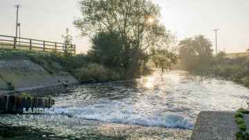
Rivers near Dungworth
- Kearsley Bk
- Porter from Source to River Sheaf
- Car Brook from Source to River Don
- Hooton Brook from Source to River Don
- Sheaf from Source to River Don
- Don from River Loxley confl to River Don Works
- Don from River Rother to River Dearne
- Greasbrough Dike from Source to River Don
- Blackburn Brook from Source to River Don
- Don from River Dearne to Mill Dyke
- Don from River Don Works to River Rother
- Hoyle Mill Stream from Source to River Went
- New Fleet Drain from source to R Went
- Went from Hoyle Mill Stream to Blowell Drain
- Frickley Beck from Source to Ea Beck
- Went from Source to Hoyle Mill Stream
- Ea Beck from the Skell to River Don
- Ea Beck from the Skell to River Don
- Ea Beck from Frickley Beck to the Skell
- Bentley Mill Stream
- Blowell Drain from Source to the Went
- Went from Blowell Drain to the River Don
- The Skell from Source to Ea Beck
- Womersley Beck from Source to Blowell Drain
- Don from Mill Dyke to River Ouse
- Swinefleet Warping Drain Source to River Ouse
- Ea Beck from Source to Frickley Beck
- Bramwith Drain from Source to River Don
- Dodworth Dyke from Source to River Dove
- Grimethorpe Dike from Source to River Dearne
- Silkstone Beck from Source to Cawthorne Dyke
- Dearne from Cawthorne Dyke to Lundwood STW
- Cudworth Dyke from Source to River Dearne
- Ings/Carr/Thurnscoe Dikes from Source to Dearne
- Bentley Brook from Source to River Dearne
- Dearne from Lundwood to River Dove
- Dearne from Bentley Brook to Cawthorne Dyke
- Rockley Dike from Source to River Dove
- Dearne from Source to Bentley Brook
- Dearne Darfield STW to River Don
- Cawthorne Dyke from Source to River Dearne
- Dove from Source to River Dearne
- Knoll Beck from Source to River Dearne
- Owler Beck from Source to River Calder
- Oakenshaw Beck from Source to River Calder
- Choke Churl Bk from Source to River Calder
- Chald from Source to River Calder
- Batley Beck from Source to River Calder
- Spen Beck from Source to River Calder
- Smithy Brook from Source to River Calder
- Calder from River Colne to River Chald
- Calder from River Chald to River Aire


