Thankerton
Thankerton is a Village in the county of South Lanarkshire.
Thankerton postcode: ML12 6NZ
There are great places to visit near Thankerton including some great towns and shopping centres.
The area around Thankerton's best towns can be found at East Kilbride.
Don't miss EK - East Kilbride's shopping centres if visiting the area around Thankerton.
Thankerton History
There are some historic monuments around Thankerton:
- Tinto Cairn,cairn on summit of Tinto Hill Prehistoric ritual and funerary: cairn (type uncertain) SM4660
- Park Knowe,enclosure 1500m SSW of Thankerton Prehistoric domestic and defensive: enclosure (domestic or defensive) SM2603
- Cornhill,Roman camp N of Roman: camp SM5278
- Kersewell Mains,cairn 1400m ENE of Prehistoric ritual and funerary: cairn (type uncertain) SM4662
- Castle Hill,earthwork,Symington Prehistoric domestic and defensive: enclosure (domestic or defensive) SM2764
- Broadhill End,cairn Prehistoric ritual and funerary: cairn (type uncertain) SM4297
- Coulter Motte,motte,Wolfclyde Secular: motte SM90082
- Carstairs Mains, Roman temporary camp 750m SE of Roman: camp SM11200
- Calla,broch 650m S of Prehistoric domestic and defensive: broch SM4540
- Calla Doone, hut-circle 500m ESE of Prehistoric domestic and defensive: hut circle, roundhouse SM11280
- Whitewellbrae Wood, henge 60m E of NE corner Prehistoric ritual and funerary: henge SM3369
- Richard's Knowe Strip,settlement 150m WNW of St John's Kirk Prehistoric domestic and defensive: settlement SM2624
- Culterpark Hill,fort Prehistoric domestic and defensive: fort (includes hill and promontory fort) SM2646
- Corbiehall Farm, enclosure 570m NNE of Prehistoric domestic and defensive: enclosure (domestic or defensive) SM13610
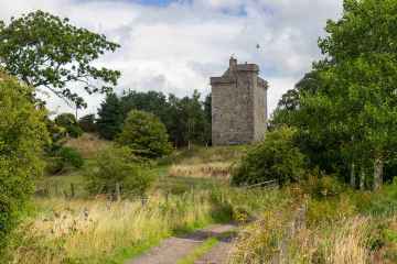
- Lamington Tower Secular: tower SM2629
- Hillend,enclosures 250m ENE of Prehistoric domestic and defensive: enclosure (domestic or defensive); Prehistoric ritual and funerary: henge SM5451
- Chester Hill,fort Prehistoric domestic and defensive: fort (includes hill and promontory fort) SM2598
- Carnwath Golf Course,motte Secular: motte SM1145
- Devonshaw Hill,cairn 700m ENE of Prehistoric ritual and funerary: cairn (type uncertain) SM4243
- Blackhouse Burn,enclosures Prehistoric ritual and funerary: enclosure (ritual or funerary) SM4063
- Windygates, hut-circle 385m NNW of Prehistoric domestic and defensive: hut circle, roundhouse SM11203
- St John's Kirk,fort 360m WNW of Prehistoric domestic and defensive: fort (includes hill and promontory fort) SM2634
- Shaw Hill,ring enclosure on summit Prehistoric ritual and funerary: enclosure (ritual or funerary) SM3743
- Devonshaw Hill,enclosure 300m NNE of summit Prehistoric domestic and defensive: enclosure (domestic or defensive) SM4512
- Castle Hill Strip,fort Prehistoric domestic and defensive: fort (includes hill and promontory fort) SM2635
- Hillhead,earthwork 930m N of homestead moat Secular: homestead moat SM2653
- The Bower of Wandel, Tower. Secular: tower SM8775
- Devonshaw Hill,fort 500m NE of Woodend Farm Prehistoric domestic and defensive: fort (includes hill and promontory fort) SM2502
- Castledykes,Roman fort,Corbiehall Roman: fort SM1139
- Hillhead,earthwork 1220m NNW of Prehistoric domestic and defensive: enclosure (domestic or defensive) SM2652
- Windgate House,bastle house and associated structures Secular: enclosure SM5257
- Devonshaw Hill,cairn Prehistoric ritual and funerary: cairn (type uncertain) SM4235
- Quothquan Law, fort Prehistoric domestic and defensive: fort (includes hill and promontory fort) SM2601
- Castle Hill,earthwork 820m SW of Prehistoric domestic and defensive: enclosure (domestic or defensive) SM2741
- Covington,castle & dovecot Secular: castle SM2599
- Castle Dykes,earthwork,Roberton Prehistoric domestic and defensive: enclosure (domestic or defensive) SM2596
- Dungavel Hill,cairn Prehistoric ritual and funerary: cairn (type uncertain) SM4261
- Castledykes, Roman camps to W, N & E of Roman fort Roman: camp SM3825
- Kersewell Mains,cairn 1400m E of Prehistoric ritual and funerary: cairn (type uncertain) SM4663
- Couthally Castle,Carnwath Secular: castle SM3909
- Snaip, settlement 380m SSW of Prehistoric domestic and defensive: settlement SM2647
- Coulter,cultivation terraces 450m SE of Prehistoric domestic and defensive: cultivation terraces SM2900
- Kersewell Mains, cairn 450m NE of Prehistoric ritual and funerary: cairn (type uncertain) SM11201
- Snaip Hill,fort Prehistoric domestic and defensive: fort (includes hill and promontory fort) SM2648
- Meadowflatt,enclosure 900m NW of Prehistoric domestic and defensive: enclosure (domestic or defensive) SM4068
- Thankerton,fort 1500m SW of Prehistoric domestic and defensive: fort (includes hill and promontory fort) SM2610
- Waulkmill, cairn 310m SE of Prehistoric ritual and funerary: cairn (type uncertain) SM11284
- Newbigging market cross Crosses and carved stones: market cross SM2307
- Greenaton Farm, enclosed settlement 250m WNW of Prehistoric domestic and defensive: enclosure (domestic or defensive) SM11214
- Baitlaws,cairn 750m ENE of Prehistoric ritual and funerary: cairn (type uncertain) SM4344