Sarn
Sarn is a Village in the county of Powys.
Sarn postcode: SY16 4FE
There are great places to visit near Sarn including some great waterfalls, mountains, caves and ancient sites.
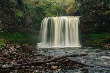
Sarn has some unmissable waterfalls nearby like Sgwd Yr Eira, Dan Yr Ogof Waterfalls, Sgwd Isaf Clun Gwyn, and Sgwd Y Pannwr.
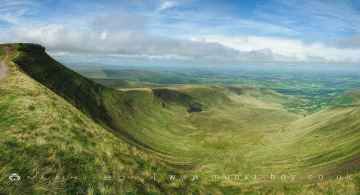
Don't miss Corn Du, and Pen y Fan's mountains if visiting the area around Sarn.
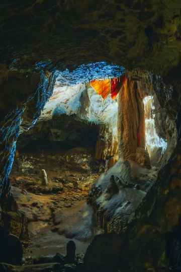
The area close to Sarn boasts some of the best caves including Dan Yr Ogof.
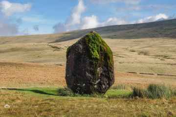
There are a several good ancient sites in the area around Sarn like Maen Llia Standing Stone.
Sarn History
There are some historic monuments around Sarn:
- Offa's Dyke: section 400yds (370m) long S of Rownal Covert
- Small enclosed Iron Age or Romano-British settlement and adjacent cultivation remains, 450m north west of Cwm Farm
- Montgomery Medieval Town, Part adjacent to Westmead, School Lane
- Offa's Dyke; Brompton Bridge section extending from Brompton Bridge to Mellington Hall Lodge
- Maen Beuno
- Offa's Dyke: two sections running 400yds (370m) S of Camlad Stream Also in Powys: Wales
- Small enclosed settlement on Castle Idris, 400m south west of Penrhiew Lodge
- Offa's Dyke: Section from Road Junction near Drewin to County Boundary
- Offa's Dyke: section 430yds (390m) in length S of Chirbury-Montgomery road
- Camp Pen-y-Gelli (revealed by aerial photography)
- Camp S of Old Hall Sarn
- Fron Derw Wood Camp
- Three Roman camps NW of Brompton Mill including tumulus and section of Offa's Dyke
- Bowl barrow on Hergan Hill, 530m north west of Myndtown
- Mount Pleasant Enclosure
- Ty'n-y-Cwm Camp
- Offa's Dyke: Section from Cwm By-Road to Hem Road
- Hen Domen Pre-Conquest Fields
- Nant-Cribau Moated House Site
- Bryn-Derwen Mound and Bailey Castle
- Ringwork and cultivation remains 260m west of St Michael's Church
- Wantyn Dyke
- Crugyn Tump Castle Mound
- Kerry Hill Stone Circle
- Offa's Dyke: section 175m east of Cefn Bronydd
- Upper Short Ditch Also in Powys: Wales
- Montgomery Medieval Town, Kerry Gate Extra Mural Settlement
- Offa's Dyke: section 430m north east of Middle Knuck Farm
- Dovecote at Chirbury Hall Farm
- Lower Min-y-Llyn Castle Mound
- Henfron Moated Site
- Nant-Cribau Castle Mound
- Sibwll Wood Camp
- Offa's Dyke: Mellington Hall Section Extending from Mellington Hall Lodge to Lower Cwm
- Offa's Dyke: Cwm Section
- Motte and bailey castle and line of Offa's Dyke adjacent to Brompton Mill
- Llethrau Camp
- Offa's Dyke: section 1/2 mile (800m) long, SE from county boundary to River Unk Also in Powys: Wales
- Offa's Dyke: section 730m south east of The Yew Tree
- Dyffryn Lane Ring Ditches & Pit Alignments (Formerly Dyffryn Lane Round Barrow)
- Offa's Dyke: section 575m north west of Myndtown
- Cefn Llan Hillfort
- Site 450m NW of Glan Mule (revealed by aerial photography)
- The Moat Mound and Bailey Castle
- Motte castle at the south end of East Dudston hamlet
- Caer-Din Ring: a small enclosed Iron Age or Romano-British settlement, an adjacent ancient field boundary, round barrow and cultivation remains
- Offa's Dyke: Section from Dudston Covert, Lymore to Lack Brook, Churchstoke
- Camp SW of Great Cloddiau Farm (revealed by aerial photography)
- Small enclosed settlement on Fron, 340m west of St John's Church
- Great Cloddiau Camp
- Tomen Madoc Castle Mound
- Offa's Dyke: section 2/3 mile (1170m) long, N from southern boundary of Rownal Covert
- Montgomery Castle
- Ucheldre Camp
- Offa's Dyke: section one mile 750yds (2290m) from Dudston Covert to a point 300yds (274m) N of Lack Brook Also in Powys: Wales
- Lower Short Ditch (Northern Part)
- Offa's Dyke: section 400m east of Cwm Farm
- Cefn Bryntalch Mound & Bailey Castle
- Ffridd Faldwyn Camp
- Offa's Dyke: section 1600yds (1460m) long, N from St John the Baptist's Church to River Unk
- Mellington Hill Round Barrow
- Upper Short Ditch
- Block Wood Round Barrow
- Castell Bryn Amlwyg: a ringwork and enclosure castle
- The Lower Short Ditch
- Offa's Dyke: section 400m south west of Springhill Farm
- Site E of Plas-Llwyn (revealed by aerial photography)
- Hen Domen Mound & Bailey Castle
- Camp 230m SE of Waen Heilyn (revealed by aerial photography)
- Offa's Dyke: section NW of Ditches Farm Also in Powys: Wales
- Dolforwyn Castle
- Pen-y-Gaer Camp
- Giant's Bank Camp
- Bowl barrow 1km south east of Hopton Bank
- Blackwood Enclosure
- Motte castle 400m north east of Upper Gwarthlow Farm
- Forden Gaer Roman Site
- Hill Tenement Enclosure
- Town Bank & Ditches
- Motte and bailey castle immediately south west of The Moat
- Offa's Dyke: Section from point 90m S of Chirbury Road to S Boundary of Nant-Cribau Park