Llangunllo
Llangunllo is a Village in the county of Powys.
Llangunllo postcode: LD7 1SW
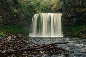
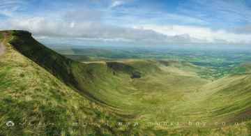
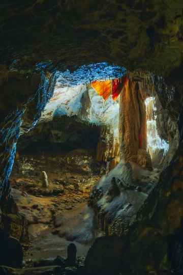
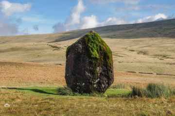
There are great places to visit near Llangunllo including some great waterfalls, mountains, caves and ancient sites.
Don't miss Sgwd Yr Eira, Dan Yr Ogof Waterfalls, Sgwd Isaf Clun Gwyn, and Sgwd Y Pannwr's waterfalls if visiting the area around Llangunllo.
There are a number of mountains near Llangunllo including Corn Du, and Pen y Fan.
The area around Llangunllo's best caves can be found at Dan Yr Ogof.
The area close to Llangunllo boasts some of the best ancient sites including Maen Llia Standing Stone.
Llangunllo History
There are some historic monuments around Llangunllo:
- Womaston Castle Mound
- Red Hill Bronze Age Barrows
- Hindwell palisaded enclosure
- Beacon Hill Round Barrows
- Bronze Age Round Barrows on Whinyard Rocks
- Town Bank and Ditch
- Offa's Dyke: Section extending 200m S to Pool House, Rhos-y-Meirch
- Ffoeslaprey Settlement
- Camp on Llanfair Hill
- The Whimble Barrow
- Offa's Dyke: section on the western slope of Llanfair Hill, 1.4km south west of Burfield
- Mound & Bailey Castle 360m ESE of St Peter's Church
- Mound and Bailey Castle 495m NW of Ditch Hill Bridge
- Black Mixen round barrow
- Cnwclas Castle
- Standing stone 350yds (320m) SE of Whitcott Keysett
- Crugyn Tump Castle Mound
- Kinnerton Castle Mound
- Offa's Dyke: section 400m north and 170m east of Selley Hall
- New Radnor: Interior of Medieval Town
- Offa's Dyke: section 650m east of Cwm-sanaham
- Mound & Bailey Castle, Bleddfa
- Offa's Dyke: section 400m south west of Springhill Farm
- Rhos Crug Round Barrows
- Camp SW of Castell Cwm Aran
- Offa's Dyke: section 730m south east of The Yew Tree
- Offa's Dyke: section 90m south of Brynorgan
- Roman Fort E of Hindwell Farm
- Rhos-crug Hill settlement
- Offa's Dyke: Section from Whitton-Presteigne Road to River Lugg
- Offa's Dyke: Section extending 1960m from Yew Tree Farm to Quarries NE of Granner Wood
- Mynachdy Moated Enclosure
- The Four Stones
- Cwm Bwch round barrow pair
- Motte and bailey castle immediately south west of The Moat
- Great Rhos round barrow
- Bowl barrow 610m south west of Springhill Cottage
- Radnor Castle
- Rhos-crug hut platform (E)
- Discoed Castle Mound
- Rhos-crug hut platform (W)
- Water-break-its-neck promontory fort
- Bowl barrow 160m north of Mellin-y-Grogue
- Castell Foel-Allt
- Castle Ring
- Small enclosed settlement on Castle Idris, 400m south west of Penrhiew Lodge
- Glog Camp
- New Radnor Medieval Town: South West Quadrant
- Shepherd's Tump round barrow
- Offa's Dyke: section 890m north west and 320m west of Little Selley
- Ednol Chapel
- Black Mixen, round barrow to NW of
- Castell Cwm Aran
- Twiscob Moated Site
- Hindwell Farm Round Barrows
- Standing Stone 400m ENE of Four Stones
- Bowl barrow 300m south of Skyborry
- Short Ditch near Beacon Lodge
- Round Barrow Near Pennant Pound
- Offa's Dyke: Section extending 1125m SW to Gilfach Wood
- Offa's Dyke: Section from Granner Wood to Burfa
- Round Barrow S of Meagram's Corner