Hyssington
Hyssington is a Village in the county of Powys.
Hyssington postcode: SY15 6AT
There are great places to visit near Hyssington including some great waterfalls, mountains, caves and ancient sites.
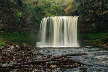
There are a several good waterfalls in the Hyssington area like Sgwd Yr Eira, Dan Yr Ogof Waterfalls, Sgwd Isaf Clun Gwyn, and Sgwd Y Pannwr.
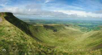
Don't miss Corn Du, and Pen y Fan's mountains if visiting the area around Hyssington.
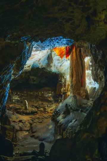
Caves to visit near Hyssington include Dan Yr Ogof.
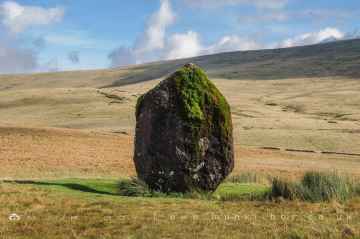
There are a several good ancient sites in the area around Hyssington like Maen Llia Standing Stone.
Hyssington History
There are some historic monuments around Hyssington:
- Offa's Dyke: Cwm Section
- Trelystan Church House Round Barrows
- Tor cairn on Stiperstones, 130m SSE of Manstone Rock.
- Pentre Camp
- Moated site and fishponds 250m south west of Middleton Farm
- Dovecote at Chirbury Hall Farm
- Castle Ring: a large univallate hillfort on Oak Hill, 600m south east of Crows Nest Farm
- Offa's Dyke: section 430m north east of Middle Knuck Farm
- Tower keep castle at Lower Lea
- Motte castle 400m north east of Upper Gwarthlow Farm
- Upper Aldress Moated Site
- Linley Hill Camp
- Motte castle at Colebatch, 100m north of Lagden
- Wagbeach adit portal, 630m and 640m south of Hogstow Mill
- Offa's Dyke: section one mile 750yds (2290m) from Dudston Covert to a point 300yds (274m) N of Lack Brook Also in Powys: Wales
- Caer-Din
- Motte and bailey castle 100m west of Holy Trinity Church
- Small enclosed Iron Age or Romano-British settlement and adjacent cultivation remains, 450m north west of Cwm Farm
- Small enclosed Iron Age settlement at Leigh Wood, 180m south of Leigh Hall
- Caerbre
- Calcot Camp
- Moated site at Leigh Hall
- Motte castle 100m south west of Lady House Farm
- Castle Ring: a large univallate hillfort, 600m south east of Meadowtown Farm
- Mitchell's Fold stone circle, standing stone and cairn 280m south west of Mitchell's Fold
- Colstey Bank Iron Age enclosure
- Three Roman camps NW of Brompton Mill including tumulus and section of Offa's Dyke
- Offa's Dyke: section 400m east of Cwm Farm
- Round cairn south of Cranberry Rock, 460m north east of Bog Cottage
- Motte and bailey castle 80m south east of Hockleton Farm
- Round cairn 38m NE of OS triangulation pillar on Manstone Rock
- Bowl barrow on Acton Bank, 170m north of Acton House
- Settlement remains of Blakemoorgate
- Site S of Bagbury (revealed by aerial photography)
- Snailbeach new smeltmill, 350m north east of Green Acres
- Round barrow S of Linley Hall
- Round cairn on Stiperstones, 350m SSW of the Devil's Chair
- Roman Gravels lead mine
- Hyssington Mound & Bailey Castle
- Hoarstone stone circle and two round cairns 400m north west of Holly Cottage
- Offa's Dyke: section 1600yds (1460m) long, N from St John the Baptist's Church to River Unk
- Offa's Dyke: Section from Road Junction near Drewin to County Boundary
- Settlement remains of Blakemoorflat
- Mellington Hill Round Barrow
- Round Barrow on Saddle to E of Corndon Hill
- Tankerville lead mine
- Ritton Castle: a slight univallate hillfort and a ringwork and bailey castle
- Bishop's Moat Mound & Bailey Castle
- Motte and bailey castle 150m north east of Wilmington
- Small enclosed settlement in Knuck Wood
- Simon's Castle
- Ringwork and cultivation remains 260m west of St Michael's Church
- Motte castle 50m north of Village Farm
- Offa's Dyke: Mellington Hall Section Extending from Mellington Hall Lodge to Lower Cwm
- Offa's Dyke: Section from Dudston Covert, Lymore to Lack Brook, Churchstoke
- Engine house at Ladywell lead mine, 850m north west of Shelve Farm
- Bowl barrow at Eaton Farm
- Motte castle 100m north of Wotherton Hall
- Bowl barrow at The Napp
- Offa's Dyke: section NW of Ditches Farm Also in Powys: Wales
- Bowl barrow 390m south east of Stanley Cottage
- Motte castle adjacent to The Mount cottage
- Bowl barrow on Round Hill, 200m west of The Napp
- Slight univallate hillfort 600m north of Roveries House
- Ringwork on Whitsburn Hill, 310m south west of Whitsburn Cottage
- Offa's Dyke; Brompton Bridge section extending from Brompton Bridge to Mellington Hall Lodge
- Motte and bailey castle and bishops' palace
- Roveries Hill Camp slight univallate hillfort 400m north east of The Roveries
- Hardwick castle motte and bailey castle 140m WSW of Hardwick Hall
- Bowl barrow on Hergan Hill, 530m north west of Myndtown
- Bury Ditches, a small multivallate hillfort on the summit of Sunnyhill
- Offa's Dyke: section 175m east of Cefn Bronydd
- Motte castle and associated settlement remains 150m NNW of Lower Down Farm
- Motte and bailey castle with associated remains of a medieval village and ridge and furrow cultivation, 200m west of St Peter's Church
- Offa's Dyke: section 1/2 mile (800m) long, SE from county boundary to River Unk Also in Powys: Wales
- Motte and bailey castle and line of Offa's Dyke adjacent to Brompton Mill
- Billings Ring large univallate hillfort
- Snailbeach lead mine
- Roundton Hillfort
- Bowl barrow 320m south of Pitcholds
- Offa's Dyke: section 575m north west of Myndtown
- Round cairn on Stiperstones, 150m south of Manstone Rock.
- Roman villa at Linley Hall
- Corndon Hill Round Cairns