Beguildy
Beguildy is a Village in the county of Powys.
Beguildy postcode: LD7 1YF
There are great places to visit near Beguildy including some great waterfalls, mountains, caves and ancient sites.
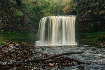
There are a number of waterfalls near Beguildy including Sgwd Yr Eira, Dan Yr Ogof Waterfalls, Sgwd Isaf Clun Gwyn, and Sgwd Y Pannwr.
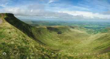
Beguildy has some unmissable mountains nearby like Corn Du, and Pen y Fan.
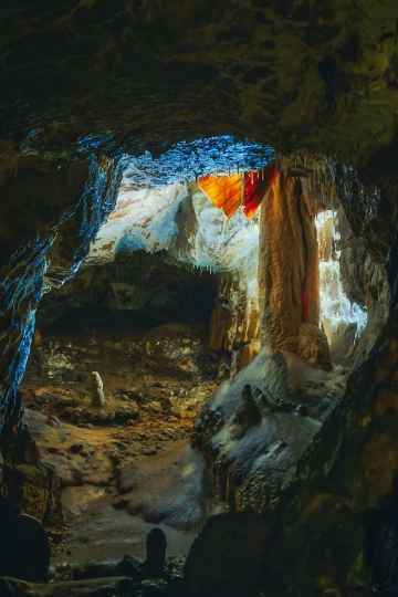
Don't miss Dan Yr Ogof's caves if visiting the area around Beguildy.
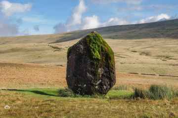
Don't miss Maen Llia Standing Stone's ancient sites if visiting the area around Beguildy.
Beguildy History
There are some historic monuments around Beguildy:
- Rhos Crug Round Barrows
- Ffoeslaprey Settlement
- Coventry Round Barrow
- Bowl barrow 1km south east of Hopton Bank
- Caer-Din Ring: a small enclosed Iron Age or Romano-British settlement, an adjacent ancient field boundary, round barrow and cultivation remains
- Glog Camp
- Rhos-crug hut platform (W)
- Offa's Dyke: section 575m north west of Myndtown
- Small enclosed settlement on Castle Idris, 400m south west of Penrhiew Lodge
- Hill Tenement Enclosure
- Offa's Dyke: section 400m south west of Springhill Farm
- Ty'n-y-Cwm Camp
- Bowl barrow on Hergan Hill, 530m north west of Myndtown
- Offa's Dyke: Section from Road Junction near Drewin to County Boundary
- Cae-glas Round Barrows
- Warren Hill Round Barrow
- Tomen Madoc Castle Mound
- Rhos-crug Hill settlement
- Mynachdy Moated Enclosure
- Lower Short Ditch (Northern Part)
- Crugyn Tump Castle Mound
- Motte and bailey castle immediately south west of The Moat
- Camp S of Old Hall Sarn
- Mellington Hill Round Barrow
- Offa's Dyke: Cwm Section
- Small enclosed Iron Age or Romano-British settlement and adjacent cultivation remains, 450m north west of Cwm Farm
- Fron Derw Wood Camp
- Camp SW of Castell Cwm Aran
- Small enclosed settlement on Fron, 340m west of St John's Church
- The Moat Mound and Bailey Castle
- The Lower Short Ditch
- Sibwll Wood Camp
- Site 450m NW of Glan Mule (revealed by aerial photography)
- Cnwclas Castle
- Kerry Hill Stone Circle
- Block Wood Round Barrow
- Round Barrow to W of Ty'n-y-ddol Hill
- Offa's Dyke: section 430m north east of Middle Knuck Farm
- Round Barrow S of Meagram's Corner
- Bowl barrow 160m north of Mellin-y-Grogue
- Short Ditch near Beacon Lodge
- Round Barrow Near Pennant Pound
- Offa's Dyke: section 175m east of Cefn Bronydd
- Offa's Dyke: section 1/2 mile (800m) long, SE from county boundary to River Unk Also in Powys: Wales
- Gors Lydan Round Barrows
- Offa's Dyke: section on the western slope of Llanfair Hill, 1.4km south west of Burfield
- Upper Short Ditch Also in Powys: Wales
- Beacon Hill Round Barrows
- Camp SW of Great Cloddiau Farm (revealed by aerial photography)
- Castell Cwm Aran
- Rhos-crug hut platform (E)
- Water-break-its-neck promontory fort
- Offa's Dyke: section 400m east of Cwm Farm
- Llethrau Camp
- Bowl barrow 610m south west of Springhill Cottage
- Offa's Dyke: section 730m south east of The Yew Tree
- Upper Short Ditch
- Castell Bryn Amlwyg: a ringwork and enclosure castle