Errol
Errol is a Village in the county of Perth and Kinross.
Errol postcode: PH2 7QW
There are great places to visit near Errol including some great rivers and streams, towns, lakes, historic buildings, ancient sites and waterfalls.
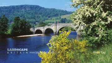
The area around Errol's best rivers and streams can be found at River Tay.
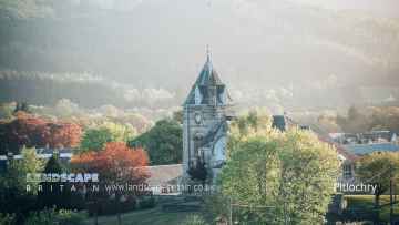
Errol has some unmissable towns nearby like Pitlochry, Dunkeld, and Aberfeldy.
The area around Errol features a number of interesting lakes including Loch Faskally, and Loch Kennard.
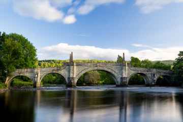
Places near Errol feature a number of interesting historic buildings including Wade's Bridge.
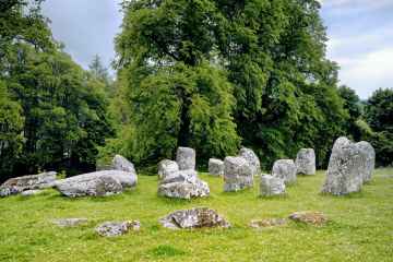
There are a several good ancient sites in the area around Errol like Croftmoraig Stone Circle.
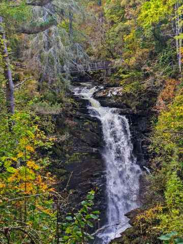
The area close to Errol boasts some of the best waterfalls including Falls of Moness.
Errol History
There are some historic monuments around Errol:
- Kirkton of Collace, cairn 420m S of Flowerdale Farm Prehistoric ritual and funerary: cairn (type uncertain) SM7188
- Fingask Castle, standing stone 320m SSE of Prehistoric ritual and funerary: standing stone SM7213
- Abdie Church, Lindores Stone Crosses and carved stones: symbol stone SM7883
- Mugdrum House,cross shaft Crosses and carved stones: cross (free-standing) SM822
- Mains of Inchture, prehistoric and later settlement and enclosures Prehistoric domestic and defensive: settlement; Secular: settlement, including deserted, depopulated and townships SM7205
- Little Dunsinane, broch 1250m E of Balmalcolm Prehistoric domestic and defensive: broch SM7289
- Lindores,eelhouse 400m NE of Abdie Parish Church Industrial: farming, food production SM3545
- Pole Hill, cairn Prehistoric ritual and funerary: cairn (type uncertain) SM6928
- Pitmiddle,deserted village Secular: settlement, including deserted, depopulated and townships SM2765
- Evelick,fort WSW of Prehistoric domestic and defensive: fort (includes hill and promontory fort) SM3095
- Collessie,cairn 390m NW of Collessie Mill Farm Prehistoric ritual and funerary: bell cairn SM3950
- Gallowflat, unenclosed settlement 150m NE of Prehistoric domestic and defensive: settlement SM7232
- Over Durdie, fort 550m ENE of Prehistoric domestic and defensive: fort (includes hill and promontory fort) SM7225
- Inchyra Farm, unenclosed settlement 500m NE of Prehistoric domestic and defensive: settlement SM7236
- Pitroddie Farm, souterrain and unenclosed settlement 250m SE of Prehistoric domestic and defensive: souterrain, earth-house SM7220
- Prehistoric settlement, 200m SSW of Willowburn Prehistoric domestic and defensive: enclosure (domestic or defensive) SM7221
- King's Seat, cairn Prehistoric ritual and funerary: cairn (type uncertain) SM7259
- Witch Knowe, barrow 130m SW of Inchyra House Prehistoric ritual and funerary: barrow SM7283
- Wester Clunie, unenclosed settlement 1000m ENE of Prehistoric domestic and defensive: settlement SM9460
- Castlehill, barrows 210m SE of Prehistoric ritual and funerary: barrow SM7307
- Norman's Law,fort Prehistoric domestic and defensive: fort (includes hill and promontory fort) SM814
- Dunsinane Hill, fort Prehistoric domestic and defensive: fort (includes hill and promontory fort) SM1595
- Rait, souterrains 130m & ring-ditch 170m S of Prehistoric domestic and defensive: souterrain, earth-house SM7201
- Ballinbreich Castle Secular: castle SM844
- Falcon Stone, barrow 320m SSW of Prehistoric ritual and funerary: barrow SM6505
- Pitroddie Farm, souterrain & unenclosed settlement E of Prehistoric domestic and defensive: souterrain, earth-house SM7219
- Abernethy Round Tower and Pictish symbol stone Crosses and carved stones: symbol stone; Ecclesiastical: tower SM90005
- Dron Chapel Ecclesiastical: cathedral SM5592
- Pole Hill, hut-circle 240m SE of triangulation point Prehistoric domestic and defensive: house SM6926
- Loanfoot, ring-ditch 370m SSW of Prehistoric ritual and funerary: henge SM7226
- Enclosures, barrows and pits 360m N of 8 Glebe Park Prehistoric domestic and defensive: enclosure (domestic or defensive); Prehistoric ritual and funerary: enclosure (ritual or funerary) SM7203
- Rait,old parish church Ecclesiastical: church SM5613
- Law Knowe, motte 380m NNW of Mains of Murie Secular: motte SM7292
- Rait Hill, fort Prehistoric domestic and defensive: fort (includes hill and promontory fort) SM7251
- Moncur, remains of timber buildings 400m WSW of Prehistoric domestic and defensive: hall SM7202
- Wast-Town Church Ecclesiastical: church SM5614
- Glenbran, ring fort 590m SE of Prehistoric domestic and defensive: ring fort SM7303
- Kilspindie, unenclosed settlement N of Mill House Prehistoric domestic and defensive: settlement SM7197
- Castlehill, unenclosed settlement 100m E of Prehistoric domestic and defensive: settlement SM7252
- Denmylne Castle 1600m SE of Newburgh Secular: castle SM852
- Barrows, 180m SW of Falcon Stone Prehistoric ritual and funerary: barrow SM6504
- Easter Clunie, unenclosed settlement 400m NW of Prehistoric domestic and defensive: settlement SM9673
- Dron Hill,fort Prehistoric domestic and defensive: fort (includes hill and promontory fort) SM3102
- Unenclosed settlement NW of Mains of Murie Prehistoric domestic and defensive: settlement SM7218
- Falcon Stone, cup-marked stone & barrow 500m SSE of Millhill Prehistoric ritual and funerary: barrow SM6503
- Enclosed settlement, 220m NW of North Cottage Prehistoric domestic and defensive: settlement SM7208
- South Inchmichael, unenclosed settlement N of Prehistoric domestic and defensive: settlement SM7199
- Glendoick, souterrains 670m WSW of Prehistoric domestic and defensive: souterrain, earth-house SM7222
- Evelick Castle Secular: castle SM7300
- Woodburnhead, cairns 700m & 760m W of Prehistoric ritual and funerary: ring cairn SM7211
- Pictish symbol-bearing cross-slab, Kinnaird Mausoleum (formerly Rossie Church) Crosses and carved stones: symbol stone SM1658
- St Madoes standing stones 200m WNW of Pitfour Castle Prehistoric ritual and funerary: standing stone SM1578
- Collairnie Castle Secular: castle SM847
- Cowden Hill, enclosure and round-houses Prehistoric domestic and defensive: homestead SM11082
- Middlebank, unenclosed settlement NE of Prehistoric domestic and defensive: settlement SM7204
- Abdie Old Kirk Ecclesiastical: church SM825
- Carpow,Roman fortress Roman: fort SM2275
- Kirkton of Collace, enclosure 380m ENE of Prehistoric domestic and defensive: enclosure (domestic or defensive) SM7266
- Lindores Abbey Ecclesiastical: abbey SM836
- Market Knowe,enclosure 340m SSE of North Bank Prehistoric domestic and defensive: enclosure (domestic or defensive) SM2879
- Blackbank, hut circles 600m NNW of Prehistoric domestic and defensive: hut circle, roundhouse SM7331
- The Grey Stone, standing stone and unenclosed settlement, 240m W of Keepers Cottage Prehistoric domestic and defensive: settlement; Prehistoric ritual and funerary: standing stone SM7230
- Newton of Glencarse, ring-ditches 270m NE of Prehistoric domestic and defensive: hut circle, roundhouse SM7246
- Prehistoric settlement, 575m SSW of Clashbenny Prehistoric domestic and defensive: settlement SM7228
- Barrow and pit alignment, 205m NE and 100m NNW of Westways Prehistoric domestic and defensive: pit alignment; Prehistoric ritual and funerary: barrow SM7249
- Inchrye,motte Secular: motte SM864
- Whitemyre, hut-circle 550m ENE of Prehistoric domestic and defensive: hut circle, roundhouse SM7200
- Moncur Castle Secular: castle SM5509
- Sandyhall, unenclosed settlement 480m ESE of Prehistoric domestic and defensive: settlement SM7231
- Ayton Chapel, Dunbog Ecclesiastical: chapel SM9852
- Newton,standing stone 200m NNE of Prehistoric ritual and funerary: standing stone SM798
- Bandirran, stone circle & standing stones 270m to 425m ENE of Prehistoric ritual and funerary: stone circle or ring SM7301