Airntully
Airntully is a Village in the county of Perth and Kinross.
Airntully postcode: PH1 4PH
There are great places to visit near Airntully including some great rivers and streams, towns, lakes, historic buildings, ancient sites and waterfalls.
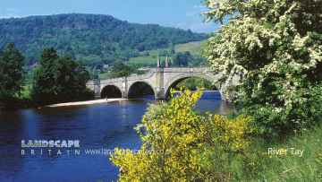
There are a number of rivers and streams near to Airntully including River Tay.
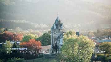
Don't miss Pitlochry, Dunkeld, and Aberfeldy's towns if visiting the area around Airntully.
Lakes to visit near Airntully include Loch Faskally, and Loch Kennard.
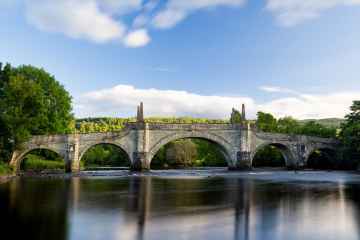
Places near Airntully feature a number of interesting historic buildings including Wade's Bridge.
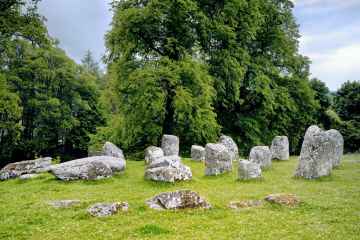
The area close to Airntully boasts some of the best ancient sites including Croftmoraig Stone Circle.
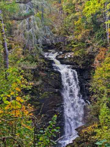
There are a several good waterfalls in the area around Airntully like Falls of Moness.
Airntully History
There are some historic monuments around Airntully:
- Ardgilzean Cottage, mound SW of Prehistoric ritual and funerary: mound (ritual or funerary) SM3402
- Mains of Huntingtower, henge, enclosures, pits and road WSW of Prehistoric domestic and defensive: enclosure (domestic or defensive); Prehistoric ritual and funerary: henge; Roman: road SM3630
- Moot Hill royal assembly place and Scone Abbey, 100m NE of Scone Palace Ecclesiastical: abbey; Secular: meeting place, thingstead, moot hill SM13595
- Meikleour House, motte W of Secular: motte SM7293
- Court Hill,cairn,Loak Prehistoric ritual and funerary: cairn (type uncertain) SM1524
- Colen, stone circle 750m NNE of Prehistoric ritual and funerary: stone circle or ring SM7305
- Mains of Fordie, souterrain 150m NW of Prehistoric domestic and defensive: souterrain, earth-house SM7130
- Stralochy, palisaded enclosure 300m S of Prehistoric domestic and defensive: palisaded enclosure SM7128
- Inchbervis Castle Secular: castle SM3763
- Clunie Castle Secular: castle SM5508
- Hill House, unenclosed settlement 100m NE of Prehistoric domestic and defensive: settlement SM7178
- Forehill, cairn 320m S of Prehistoric ritual and funerary: cairn (type uncertain) SM7288
- Blairhall, barrow cemetery and cursus S of Prehistoric ritual and funerary: cursus/bank barrow SM6932
- Meikleour, enclosures 500m NE of Prehistoric domestic and defensive: enclosure (domestic or defensive); Prehistoric ritual and funerary: enclosure (ritual or funerary) SM7027
- Sheriffton, barrow cemetery 200m NE of Prehistoric ritual and funerary: barrow SM6723
- North Blackruthven,enclosures 300m NE of Prehistoric ritual and funerary: enclosure (ritual or funerary) SM3633
- Bonhard Park, unenclosed settlement SE of Prehistoric domestic and defensive: settlement SM6708
- Kemp's Hold,fort Prehistoric domestic and defensive: fort (includes hill and promontory fort) SM6122
- Gold Castle, enclosure 200m SW of Donald's Bank Prehistoric domestic and defensive: enclosure (domestic or defensive) SM7572
- Castle Hill,motte W of Mains of Cargill Secular: motte SM3198
- King's Stone, standing stone 90m SE of Denmarkfield Farm Prehistoric ritual and funerary: standing stone SM1556
- Byres, ring-ditch and souterrain 330m NE of Prehistoric domestic and defensive: house SM7179
- Lochton House, enclosure 350m ESE of Prehistoric domestic and defensive: enclosure (domestic or defensive) SM6722
- Huntingtower Castle Secular: castle SM90164
- Wester Bonhard, unenclosed settlement 300m NNW of Prehistoric domestic and defensive: settlement SM6710
- Ring-ditch 448m S of Leys of Marlee Prehistoric ritual and funerary: barrow SM7171
- Cambusmichael, enclosure & souterrain 100m N of Prehistoric domestic and defensive: enclosure (domestic or defensive) SM7180
- Kinclaven Castle Secular: castle SM1640
- Mains of Gourdie, ring-ditch 120m SSW of Prehistoric domestic and defensive: hut circle, roundhouse SM6895
- Cairnton Cottage,cairn Prehistoric ritual and funerary: cairn (type uncertain) SM1508
- Loanleven, enclosure 300m SSW of Prehistoric ritual and funerary: enclosure (ritual or funerary) SM8755
- Middle Gourdie, unenclosed settlement 400m SE of Prehistoric domestic and defensive: settlement SM6894
- Barrow, 420m SE of Lochton House Prehistoric ritual and funerary: barrow SM6946
- Middle Gourdie, souterrain 380m SSW of Prehistoric domestic and defensive: souterrain, earth-house SM6896
- Pitsundry, standing stone 250m W of Prehistoric ritual and funerary: standing stone SM1577
- Campsie Linn, grange site Ecclesiastical: grange/farm - secular buildings associated; Secular: manor house SM11143
- Balcairn, cairn 350m W of Prehistoric ritual and funerary: cairn (type uncertain) SM7285
- Balholmie Cottage, unenclosed settlement 150m N of Prehistoric domestic and defensive: settlement SM7028
- Glendelvine House, cairn 330m S of Prehistoric ritual and funerary: cairn (type uncertain) SM7284
- Balhomie, cup-marked stone 95m N of Prehistoric ritual and funerary: cupmarks or cup-and-ring marks and similar rock art SM7326
- Damside, stone row 900m SW of Prehistoric ritual and funerary: stone rows SM7297
- Wester Drumatherty, unenclosed settlement 300m W of Prehistoric domestic and defensive: settlement SM7165
- Steed Stalls,Roman camp Roman: camp SM3022
- Stralochy, palisaded enclosure 370m S of Prehistoric domestic and defensive: palisaded enclosure SM7133
- Blackfaulds, stone circle 450m WSW of Prehistoric ritual and funerary: stone circle or ring SM7295
- Middle Gourdie, palisaded enclosure & unenclosed settlement 800m SW of Prehistoric domestic and defensive: palisaded enclosure SM7185
- Ninewells, kerb cairn 150m NNW of Prehistoric ritual and funerary: cairn (type uncertain) SM7126
- Stone circle, 52m southwest of Druid's Park House Prehistoric ritual and funerary: stone circle or ring SM1571
- Newbigging Farm,cup and ring marked stone 225m WSW of Prehistoric ritual and funerary: cupmarks or cup-and-ring marks and similar rock art SM1509
- Inchtuthil, Roman fortress Roman: fort SM1606
- Cambusmichael, palisaded enclosure 50m NW of Prehistoric domestic and defensive: palisaded enclosure SM7183
- Castle Hill, castle and site of church 70m NE of Clunie Church Secular: castle SM1638
- Glendelvine House, barrow and standing stone 200m S of Prehistoric ritual and funerary: barrow SM7127
- Loak, standing stone 470m SSE of Prehistoric ritual and funerary: standing stone SM1562
- Mains of Fordie, cairn 450m W of Prehistoric ritual and funerary: cairn (type uncertain) SM7137
- Cairn, 110m SW of Almondbank Filling Station Prehistoric ritual and funerary: cairn (type uncertain) SM2267
- Bertha, Roman Fort Roman: fort SM2403
- Gellybanks, standing stones 620m ESE of Prehistoric ritual and funerary: standing stone SM1548
- Cairn Muir, cairn 190m NW of Cairnmuir Prehistoric ritual and funerary: cairn (type uncertain) SM7287
- Leys of Marlee, ring-ditch 400m SSW of Prehistoric ritual and funerary: barrow SM7170
- Inchtuthil Farm,fort N of Prehistoric domestic and defensive: fort (includes hill and promontory fort) SM1596
- Grassy Walls, Roman camp and prehistoric settlement, Sheriffton Prehistoric domestic and defensive: settlement; Roman: camp SM4072
- Ardlin, unenclosed settlement 700m W of Prehistoric domestic and defensive: settlement SM7186
- Balgarvie, unenclosed settlement 350m ESE of Prehistoric domestic and defensive: settlement SM6947
- Roman watch tower and unenclosed settlement, 310m NW of Strathview Cottage SM7182
- Dunkeld, two standing stones 450m WNW of Newtyle Prehistoric ritual and funerary: standing stone SM1541
- Mains of Airleywight,cairn Prehistoric ritual and funerary: cairn (type uncertain) SM2898
- Blackhillock, souterrain 50m W of Prehistoric domestic and defensive: souterrain, earth-house SM7132
- Millhole, unenclosed settlement 450m ESE of Prehistoric domestic and defensive: house SM7166
- Cambusmichael Church Ecclesiastical: church SM5641
- Cramflat,standing stone E of Prehistoric ritual and funerary: standing stone SM1527
- Mill of Bonhard, unenclosed settlement and standing stone 200m S of Prehistoric domestic and defensive: settlement; Prehistoric ritual and funerary: standing stone SM6711
- Loch of Clunie,crannog 450m NNE of Clunie Castle Prehistoric domestic and defensive: crannog SM5505
- Over Benchil, standing stone 100m WSW of Prehistoric ritual and funerary: standing stone SM1574
- Murthly Castle, standing stone 300m SSW of Prehistoric ritual and funerary: standing stone SM1570
- Shianbank, stone circles and pillboxes 325m E of 20th Century Military and Related: Pillbox; Prehistoric ritual and funerary: stone circle or ring SM2314
- Berryhill, mortuary enclosures and pit-alignment 150m N of Prehistoric ritual and funerary: enclosure (ritual or funerary) SM7184
- Staredam, standing stones 80m SW of Prehistoric ritual and funerary: standing stone SM1584
- Blindwells, stone circle 380m ENE of Prehistoric ritual and funerary: stone circle or ring SM7299
- Meikle Obney, standing stone 260m E of Prehistoric ritual and funerary: standing stone SM1592
- Leys of Marlee Farm,stone circle,Blairgowrie-Lethendy Road Prehistoric ritual and funerary: stone circle or ring SM1560
- Tammieteeth, cairn 500m W of Cairnbeddie Prehistoric ritual and funerary: cairn (type uncertain) SM7286
- New Scone,stone circle,Grey Stanes Prehistoric ritual and funerary: stone circle or ring SM1579
- Loanhead, standing stones 450m NE of Prehistoric ritual and funerary: standing stone SM7298
- Fort, 80m SE of 65 Lumsden Crescent, Almondbank SM2641
- East Cult,two standing stones and cup-marked stone W of Prehistoric ritual and funerary: standing stone SM1544
- Glendelvine, souterrain 90m NW of Lodge Cottages Prehistoric domestic and defensive: souterrain, earth-house SM7135
- Culthill, souterrains 100m ESE of Prehistoric domestic and defensive: souterrain, earth-house SM7129