


Ramsden
Ramsden is a Village in the county of Oxfordshire.
There are great places to visit near Ramsden including some great ancient sites, cities, shopping centres, towns and historic buildings.
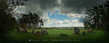
The Rollright Stones, The King Stone, The Whispering Knights, and The Kings Men are some of Ramsden best ancient sites to visit near Ramsden.
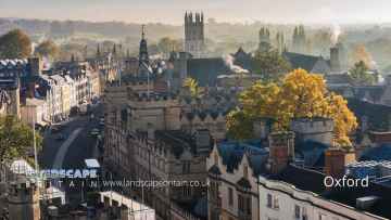
Places near Ramsden feature a number of interesting cities including Oxford.
Shopping Centres to visit near Ramsden include Westgate Oxford.
Ramsden is near some unmissable towns like Banbury,
Ramsden is near some unmissable historic buildings like Upton House,
Ramsden History
There are some historic monuments around Ramsden:
- Section of the north Oxfordshire Grim's Ditch running east from the River Evenlode opposite Cornbury Park
- 145m section of the north Oxfordshire Grim's Ditch situated 200m west of Grimsdyke Farm
- Great kitchen of manor house
- One of a pair of bowl barrows 370m NW of High Lodge
- Over Chalford medieval settlement
- Callow Hill Roman villa
- Hawk Stone standing stone 700m south of Claridges Barn
- Bowl barrow in Kingswood Brake, 450m WNW of Wood Farm
- Sites discovered by aerial photography, near Foxley Farm
- Bowl barrow 150m north-west of North Lodge, Cornbury Park
- Linear earthworks east of Callow Hill Roman villa forming part of the north Oxfordshire Grim's Ditch
- The Devil's Quoits
- The Roundabout hillfort, 460m west of Barter's Hill Farm
- A pair of Roman camps and a section of a post-medieval sunken road situated in the north eastern corner of Cornbury Park
- Pair of Bronze Age bowl barrows 150m north of Roustage Wood
- Waterman's Lodge bowl barrow, one of a pair of Bronze Age barrows on the western edge of Wychwood Forest
- Site of 19th century pottery factory NW of Leafield
- Bowl barrow situated in Round Clump, Ditchley Park
- 1km section of the north Oxfordshire Grim's Ditch running from Out Wood to Berring's Wood
- Roman villa and associated bath house 450m north west of Lower Field Farm
- Nether Chalford medieval settlement
- Leafield Barrow: a motte castle 220m north west of St Michael and All Angels Church
- Knollbury camp hillfort
- Earthwork at Lowbarrow Farm
- Pump Copse earthwork
- 1100m section of the north Oxfordshire Grim's Ditch at Model Farm on the Ditchley Park Estate
- Rectangular earthwork enclosure in Hill Wood, 650m south east of Grimsdyke Farm
- Barn at Rectory Farm, Church Enstone
- 90m section of the north Oxfordshire Grim's Ditch 350m south of Grim's Dyke Farm
- Taston standing stone 12m north of Taston village cross
- Bowl barrow 80m south east of Spelsburydown Farm barns
- Pair of Bronze Age round barrows and surrounding Civil War fieldworks 180m north-west of Park Farm
- Brize's Lodge bowl barrow, 400m east of Gospel Oak
- Pair of confluent bowl barrows 200m SSW of Bockett's Corner on Leigh Hale Plain
- Civil War artillery fieldwork 370m NNW of Park Farm, Cornbury Park
- Anglo-Saxon burial mound 450m north west of University Farm
- Bishop of Winchester's Palace, 90m east of St Mary's Church
- Lyneham long barrow and standing stone, 480m north east of Hill Barn
- Ascott Earl motte and bailey castle
- One of a pair of bowl barrows 370m north-west of High Lodge
- Barrow Place earthwork, 370m south west of Lodge Farm, Ditchley
- Bowl barrow 500m south west of Hill Farm, Lidstone
- Section of the north Oxfordshire Grim's Ditch running into the northern edge of Shilcott Wood on the Ditchley Estate
- North Leigh Roman villa 300m NNE of Upper Riding Farm
- Lew village cross
- Section of the north Oxfordshire Grim's Ditch 350m ENE of Ditchley House
- 80m section of the north Oxfordshire Grim's Ditch 150m WSW of Ditchley Gate in Blenheim Park
- Long barrow 250m south of Ellen's Lodge in Shilcott Wood on the Ditchley Park Estate
- Hoar Stone portal dolmen situated in Enstone Firs
- Ten medieval pillow mounds and part of an associated enclosure 300m north west of Combe Lodge
- Rectangular enclosures 1100yds (1010m) NW of Mount Owen Farm
- Asthall Barrow: an Anglo-Saxon burial mound 100m SSW of Barrow Farm
- Lowland Barn Romano-British farmstead 200m north west of Bury Hill
- 900m section of the north Oxfordshire Grim's Ditch 200m north of Grim's Dyke Farm, running north into Hark Wood
- Ditchley Park Roman villa and part of an associated field system 450m ENE of Lodge Farm
- Long barrow 150m west of Churchill Copse in Wychwood Forest
- Ascott d'Oyley 12th century motte and bailey castle and associated earthworks
- Bowl barrow 525m north of Barter's Hill Farm
- Pair of bowl barrows immediately south of Blindwell Wood
- 240m section of the north Oxfordshire Grim's Ditch between Grim's Dyke Farm and the B4437 Charlbury to Woodstock road
- Pair of Bronze Age bowl barrows situated on Maple Hill in Wychwood Forest
- Bowl barrow 270m east of Spelsburydown Farm barns
- Medieval moat surrounding High Lodge, 400m north east of Kingstanding Farm
- Skew Plantation bowl barrow
- 380m section of the north Oxfordshire Grim's Ditch 200m ENE of Kiddington Lodge
- Site of Langley Palace royal hunting lodge, an associated enclosure and later garden earthworks at Langley Farm
- Lee's Rest Earthwork: a probable Romano-Celtic temple 200m north east of Lee's Rest Farm
- Gagingwell cross, 80m west of Abbey Farm
- Pair of bowl barrows at Hawksnest Copse in Wychwood Forest
- Bowl barrow 200m west of Hawksnest Copse in Wychwood Forest
- Stonesfield Roman villa
- Medieval settlement and church of Asterleigh
- Section of the north Oxfordshire Grim's Ditch and a section of Akeman Street Roman road immediately south east of North Lodge in Blenheim Great Park
- Slatepits Copse long barrow, 1km SE of High Lodge in Wychwood Forest
- Bowl barrow 60m north of Wood Farm
- Minster Lovell Hall
- Dovecote 125m north of Minster Lovell Hall
- Fawler Roman villa
- Oaklands Farm Roman villa
- Taston village cross
- Ring ditch near Long Hanborough
- Squire's Clump Anglo-Saxon burial mound 500m south west of Iron Buildings
- Walcot ornamental fishponds and garden earthworks
- Besbury Lane bowl barrow, 450m north east of Conduit Farm
- Section of the north Oxfordshire Grim's Ditch west of Common Farm
- Bowl barrow 400m north west of Ranger's Lodge in Cornbury Park
- Long barrow situated in Southlawn Plain Woods
- Butter cross
- The remains of a medieval moated manor, priory, settlement and associated features, Cogges
- Bowl barrow 150m east of Waterman's Lodge: one of a pair of Bronze Age barrows on the western edge of Wychwood Forest
Places to see near Ramsden


Lakes near Ramsden
Canals near Ramsden
Rivers near Ramsden
- Thame upstream of Aylesbury
- Cuttle Brook
- Dorton, Chearsley and Waddesdon Brooks
- Stoke Brook Aylesbury
- Baldon Brook (South of Oxford)
- Holton Brook and tributaries
- Chinor Brook and Sydenham Brook
- Kingsey Cuttle Brook and tributaries at Thame
- Latchford Brook at Tetsworth
- Hardwick Brook (Source to Thame)
- Lewknor Brook
- Thame (Scotsgrove Brook to Thames)
- Scotsgrove Brook (upstream Kingsey Cuttle Brook)
- Peppershill and Shabbington Brooks
- Worminghall Brook and tributaries
- Thame (Aylesbury to Scotsgrove Brook)
- Haseley Brook
- Chalgrove Brook
- Bear Brook and Wendover Brook
- Fleet Marston Brook, Denham Brook, Pitchcott Brook west
- Berrick Stream and Lady Brook
- Wye (High Wycombe fire station to Thames)
- Sulham Brook
- Hamble Brook
- Mill Brook and Bradfords Brook system, Wallingford
- Cholsey Brook and tributaries
- Hughenden Stream
- Ewelme Stream (Source to Thames)
- Ewelme Stream (Source to Thames)
- Thames (Reading to Cookham)
- Wye (Source to High Wycombe fire station)
- Thames Wallingford to Caversham
- Pang
- Letcombe Brook
- Ock and tributaries (Land Brook confluence to Thames)
- Sandford Brook (source to Ock)
- Frilford and Marcham Brook
- Childrey Brook and Norbrook at Common Barn
- Ock (to Cherbury Brook)
- Childrey and Woodhill Brooks
- Stutfield Brook (source to Ock)
- Ginge Brook and Mill Brook
- Thames (Evenlode to Thame)
- Moor Ditch and Ladygrove Ditch
- Northfield Brook (Source to Thames) at Sandford
- Cow Common Brook and Portobello Ditch
- Cherwell (Bletchingdon to Ray)
- Bloxham Brook (Source to Sor Brook)
- Highfurlong Brook (to Cherwell)
- Hanwell Brook
- Tadmarton Stream (Source to Sor Brook)
- Upper Swere (Source to Wigginton)
- Hook Norton Brook (Source to Swere)
- Sor Brook (Broughton to Cherwell)
- Farthinghoe Stream (Source to Cherwell) and tributaries
- Swere (Wigginton to Cherwell)
- Ockley Brook and Croughton Brook (Source to Cherwell)
- Ashby Brook (Source to Cherwell)
- Bayswater Brook
- Deddington Brook (Source to Cherwell)
- Sor Brook (Source to Broughton)
- Cherwell (Ray to Thames) and Woodeaton Brook
- Cherwell (Source to Trafford Bridge)
- Chacombe Brook (Source to Cherwell)
- Cherwell (Ashby Brook to Cropredy)
- Clayton and Wormleighton Brook, Source to Highfurlong Brook
- Cherwell (Cropredy to Nell Bridge)
- Shutford Stream (Source to Sor Brook)
- Cherwell (Nell Bridge to Bletchingdon)
- Littlestock Stream to tributary of Evenlode at Shipton
- Evenlode (Source to Four Shires S) and Longborough Stream
- Glyme (Enstone to Dorn)
- Little Compton Brook and tributaries (Source to Evenlode)
- Evenlode (Bledington to Glyme confluence)
- Glyme (Dorn confluence to Evenlode)
- Evenlode (Compton Bk to Bledington Bk) and 4 Shires
- Heythorpe Stream and tributaries
- Cornwell Brook and tributaries (Source to Evenlode)
- Coldron and Taston Brooks
- Sars Brook (source to Evenlode downstream Bledington)
- Bledington Brook (Source to Evenlode)
- Evenlode (Glyme to Thames)
- Glyme (Source to Enstone)
- Westcote Brook (source to Evenlode at Bledington)
- Dorn (Source to Glyme)


