


Longcot
Longcot is a Village in the county of Oxfordshire.
There are great places to visit near Longcot including some great ancient sites, cities, shopping centres, towns and historic buildings.
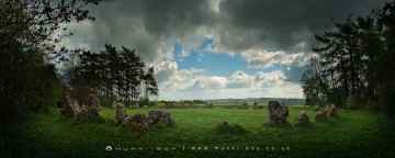
There are a number of ancient sites near Longcot including The Rollright Stones, The King Stone, The Whispering Knights, and The Kings Men.
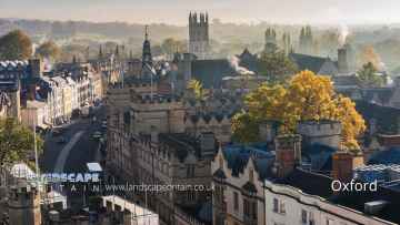
Places near Longcot feature a number of interesting cities including Oxford.
Longcot is near some unmissable shopping centres like Westgate Oxford,
There are a number of towns near to Longcot including Banbury.
Historic Buildings to visit near Longcot include Upton House.
Longcot History
There are some historic monuments around Longcot:
- Halfpenny Bridge
- Bowl barrow 270m north-east of Sevenbarrows House: part of the Seven Barrows cemetery
- Watchfield Anglo-Saxon cemetery
- Alfred's Castle univallate hillfort
- Maddle Farm Roman settlement
- Bourton village cross
- Bowl barrow 390m N of Sevenbarrows House: part of the Seven Barrows cemetery
- Trackways 500yds (460m) E of St George's Church
- Highworth circle 350m north east of Common Farm
- Bell barrow 400m north-east of Postdown Farm: part of the Seven Barrows cemetery
- Burroway enclosure
- Sparsholt Down round barrow, 900m north of Seven Barrows round barrow cemetery
- Lynchets 850m west of Ridgeway Farm
- Wayland's Smithy chambered long barrow, including an earlier barrow and Iron Age and Roman boundary ditches
- Bowl barrow 300m north of Postdown Farm: part of the Seven Barrows cemetery
- A double bell barrow, a saucer barrow and four bowl barrows, 450m south-east of Sevenbarrows House: part of the Seven Barrows cemetery
- Highworth circle 200m north east of Common Farm
- Medieval settlement and associated ridge and furrow south-west of Eastrop Farm
- Bowl barrow on Hinton Downs
- Neolithic long barrow and Romano-British inhumation cemetery 70m north of Uffington Castle on Whitehorse Hill
- Bronze Age bowl barrow and a pair of Anglo-Saxon burial mounds 70m south of the White Horse on Whitehorse Hill
- Bowl barrow 350m south-west of Harley Bushes, Bishopstone Downs
- Medieval settlement remains immediately south east of Fresden Farm
- Round barrow cemetery at Seven Barrows, Lambourn
- Fognam Clump field system
- Long mortuary enclosure and associated barrow 120m south of Rushey Weir
- Medieval settlement remains at Inglesham
- Bowl barrow 240m east of Sevenbarrows House: part of the Seven Barrows cemetery
- Three round barrows forming the core of a dispersed barrow cemetery on Idstone Down
- Bowl barrow 280m north of Downs Barn
- Settlement 700m NE of Lechlade
- Bowl barrow 250m north of Sevenbarrows House: Part of the Seven Barrows cemetery
- Earthwork in Ewedown Copse
- Hall Place
- Radcot Bridge
- Dragon Hill
- Long barrow 700m north of Liddington Warren Farm
- Highworth circle 200m south east of Common Farm
- Medieval settlement remains at Sevenhampton
- Settlement site
- Two Highworth circles 250m and 325m north of Eastrop Farm
- Roman villa 630m south west of Starveall Farm
- Tithe barn
- Four bowl barrows 400m south-east of Sevenbarrows House: part of the Seven Barrows cemetery
- Multi-period settlement, cemetery, and ceremonial complex W of Lechlade
- The White Horse hill figure 170m NNE of Uffington Castle on Whitehorse Hill
- Enclosures and trackways
- Long barrow 400m north west of Sevenbarrows House
- Ring ditches
- Fognam Clump and adjacent field system
- Bowl barrow 200m north of Downs Barn
- St John's Hospital
- Causewayed enclosure and associated features on the south bank of the River Thames, immediately west of Rushey Weir
- Disc barrow 700m north-east of Sevenbarrows House: part of the Seven Barrows cemetery
- Wyke monastic grange and section of 18th century turnpike road, 780m south of Tudor Farm
- Iron Age and Romano British settlement remains and associated features, 1km south east of Leaze Farm
- Linear boundary earthwork west of Liddington Castle
- Two bowl barrows 300m north-east of Sevenbarrows House: part of the Seven Barrows cemetery
- Little Coxwell camp
- Churchyard cross, 10m south east of St John the Baptist's Church
- Liddington Castle
- Badbury camp
- Hardwell Camp promontory fort
- Interrupted ditch system
- Uffington Castle: a univallate hillfort immediately north of the Ridgeway on Whitehorse Hill
- Enclosures 1500m SE of Little Faringdon
Places to see near Longcot


Lakes near Longcot
Canals near Longcot
Rivers near Longcot
- Thame upstream of Aylesbury
- Cuttle Brook
- Dorton, Chearsley and Waddesdon Brooks
- Stoke Brook Aylesbury
- Baldon Brook (South of Oxford)
- Holton Brook and tributaries
- Chinor Brook and Sydenham Brook
- Kingsey Cuttle Brook and tributaries at Thame
- Latchford Brook at Tetsworth
- Hardwick Brook (Source to Thame)
- Lewknor Brook
- Thame (Scotsgrove Brook to Thames)
- Scotsgrove Brook (upstream Kingsey Cuttle Brook)
- Peppershill and Shabbington Brooks
- Worminghall Brook and tributaries
- Thame (Aylesbury to Scotsgrove Brook)
- Haseley Brook
- Chalgrove Brook
- Bear Brook and Wendover Brook
- Fleet Marston Brook, Denham Brook, Pitchcott Brook west
- Berrick Stream and Lady Brook
- Wye (High Wycombe fire station to Thames)
- Sulham Brook
- Hamble Brook
- Mill Brook and Bradfords Brook system, Wallingford
- Cholsey Brook and tributaries
- Hughenden Stream
- Ewelme Stream (Source to Thames)
- Ewelme Stream (Source to Thames)
- Thames (Reading to Cookham)
- Wye (Source to High Wycombe fire station)
- Thames Wallingford to Caversham
- Pang
- Letcombe Brook
- Ock and tributaries (Land Brook confluence to Thames)
- Sandford Brook (source to Ock)
- Frilford and Marcham Brook
- Childrey Brook and Norbrook at Common Barn
- Ock (to Cherbury Brook)
- Childrey and Woodhill Brooks
- Stutfield Brook (source to Ock)
- Ginge Brook and Mill Brook
- Thames (Evenlode to Thame)
- Moor Ditch and Ladygrove Ditch
- Northfield Brook (Source to Thames) at Sandford
- Cow Common Brook and Portobello Ditch
- Cherwell (Bletchingdon to Ray)
- Bloxham Brook (Source to Sor Brook)
- Highfurlong Brook (to Cherwell)
- Hanwell Brook
- Tadmarton Stream (Source to Sor Brook)
- Upper Swere (Source to Wigginton)
- Hook Norton Brook (Source to Swere)
- Sor Brook (Broughton to Cherwell)
- Farthinghoe Stream (Source to Cherwell) and tributaries
- Swere (Wigginton to Cherwell)
- Ockley Brook and Croughton Brook (Source to Cherwell)
- Ashby Brook (Source to Cherwell)
- Bayswater Brook
- Deddington Brook (Source to Cherwell)
- Sor Brook (Source to Broughton)
- Cherwell (Ray to Thames) and Woodeaton Brook
- Cherwell (Source to Trafford Bridge)
- Chacombe Brook (Source to Cherwell)
- Cherwell (Ashby Brook to Cropredy)
- Clayton and Wormleighton Brook, Source to Highfurlong Brook
- Cherwell (Cropredy to Nell Bridge)
- Shutford Stream (Source to Sor Brook)
- Cherwell (Nell Bridge to Bletchingdon)
- Littlestock Stream to tributary of Evenlode at Shipton
- Evenlode (Source to Four Shires S) and Longborough Stream
- Glyme (Enstone to Dorn)
- Little Compton Brook and tributaries (Source to Evenlode)
- Evenlode (Bledington to Glyme confluence)
- Glyme (Dorn confluence to Evenlode)
- Evenlode (Compton Bk to Bledington Bk) and 4 Shires
- Heythorpe Stream and tributaries
- Cornwell Brook and tributaries (Source to Evenlode)
- Coldron and Taston Brooks
- Sars Brook (source to Evenlode downstream Bledington)
- Bledington Brook (Source to Evenlode)
- Evenlode (Glyme to Thames)
- Glyme (Source to Enstone)
- Westcote Brook (source to Evenlode at Bledington)
- Dorn (Source to Glyme)


