


Ashbury
Ashbury is a Village in the county of Oxfordshire.
There are great places to visit near Ashbury including some great ancient sites, cities, shopping centres, towns and historic buildings.
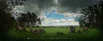
Ashbury has some unmissable ancient sites nearby like The Rollright Stones, The King Stone, The Whispering Knights, and The Kings Men.
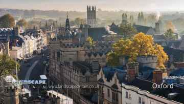
Ashbury is near some unmissable cities like Oxford,
There are a number of shopping centres near to Ashbury including Westgate Oxford.
Places near Ashbury feature a number of interesting towns including Banbury.
Historic Buildings to visit near Ashbury include Upton House.
Ashbury History
There are some historic monuments around Ashbury:
- Two bowl barrows in Shipley Bottom
- Lynchets 850m west of Ridgeway Farm
- Disc barrow 700m north-east of Sevenbarrows House: part of the Seven Barrows cemetery
- Bronze Age bowl barrow and a pair of Anglo-Saxon burial mounds 70m south of the White Horse on Whitehorse Hill
- Bowl barrow 240m east of Sevenbarrows House: part of the Seven Barrows cemetery
- Linear boundary earthwork west of Liddington Castle
- Bowl barrow 350m south-west of Harley Bushes, Bishopstone Downs
- Three round barrows forming the core of a dispersed barrow cemetery on Idstone Down
- Bourton village cross
- Little Coxwell camp
- Neolithic long barrow and Romano-British inhumation cemetery 70m north of Uffington Castle on Whitehorse Hill
- Disc barrow 780m north east of North Farm
- Bowl barrow 280m north of Downs Barn
- Four bowl barrows 400m south-east of Sevenbarrows House: part of the Seven Barrows cemetery
- Bowl barrow 200m north of Downs Barn
- Alfred's Castle univallate hillfort
- Uffington Castle: a univallate hillfort immediately north of the Ridgeway on Whitehorse Hill
- Membury Camp
- Highworth circle 200m north east of Common Farm
- Long barrow 400m north west of Sevenbarrows House
- Bowl barrow 150m north of Half Moon Wood
- Medieval settlement, cultivation remains and boundary 550m north west of Upham Hall
- Medieval settlement remains at Sevenhampton
- Bell barrow 400m north-east of Postdown Farm: part of the Seven Barrows cemetery
- Membury Camp
- Bowl barrow 400m north-west of Aldbourne Warren Farm
- Barrow cemetery 200m south of Whitecomb Plantation
- Bowl barrow on Hinton Downs
- Highworth circle 200m south east of Common Farm
- Bowl barrow 850m WNW of Dudmore Lodge
- Bowl barrow on Farncombe Down, 500m south west of Baydon Hole
- Banjo enclosure 480m south west of Cheldene
- Two Highworth circles 250m and 325m north of Eastrop Farm
- Ditch on Boydon Hole Farm
- Bowl barrow 270m north-east of Sevenbarrows House: part of the Seven Barrows cemetery
- Long barrow 700m north of Liddington Warren Farm
- The White Horse hill figure 170m NNE of Uffington Castle on Whitehorse Hill
- Wayland's Smithy chambered long barrow, including an earlier barrow and Iron Age and Roman boundary ditches
- Two bowl barrows 300m north-east of Sevenbarrows House: part of the Seven Barrows cemetery
- The Giant's Grave round barrow cemetery
- Whitefield Hill ditch
- Medieval settlement and associated ridge and furrow south-west of Eastrop Farm
- Lambourn Cross
- Round barrow cemetery at Seven Barrows, Lambourn
- Cross dyke and field banks in Peaks Wood 210m east of Hellscomb Cottages
- Two bowl barrows 400m south of Whitecomb Plantation
- Roman villa 630m south west of Starveall Farm
- Bowl barrow on Sugar Hill
- Bowl barrow 880m north east of Lower Upham Farm
- Bowl barrow 250m north of Sevenbarrows House: Part of the Seven Barrows cemetery
- Hardwell Camp promontory fort
- Hall Place
- Three Highworth circles 600m east of North Leaze Farm
- Bowl barrow 390m N of Sevenbarrows House: part of the Seven Barrows cemetery
- Bockhampton deserted medieval village
- Bowl barrow 700m south west of Liddington Warren Farm
- Church Hill earthwork
- Earthwork in Ewedown Copse
- Tithe barn
- Bowl barrow 300m north of Postdown Farm: part of the Seven Barrows cemetery
- Sparsholt Down round barrow, 900m north of Seven Barrows round barrow cemetery
- Liddington Castle
- Bowl barrow 850m north west of North Farm
- Watchfield Anglo-Saxon cemetery
- Two Highworth circles 600m south east of North Leaze Farm
- Highworth circle 350m north east of Common Farm
- Maddle Farm Roman settlement
- Boundary ditch E of Near Down
- A double bell barrow, a saucer barrow and four bowl barrows, 450m south-east of Sevenbarrows House: part of the Seven Barrows cemetery
- Bowl barrow on Sugar Hill
- Medieval settlement and prehistoric field system 520m north east and 760m east of Snap Farm
- Village cross
- Badbury camp
- Four Highworth circles 150m north east of Pickett's Copse
- Dragon Hill
- Site of Roman town, W of Wanborough House
- Fognam Clump field system
- Medieval settlement remains immediately south east of Fresden Farm
- Fognam Clump and adjacent field system
Places to see near Ashbury


Lakes near Ashbury
Canals near Ashbury
Rivers near Ashbury
- Thame upstream of Aylesbury
- Cuttle Brook
- Dorton, Chearsley and Waddesdon Brooks
- Stoke Brook Aylesbury
- Baldon Brook (South of Oxford)
- Holton Brook and tributaries
- Chinor Brook and Sydenham Brook
- Kingsey Cuttle Brook and tributaries at Thame
- Latchford Brook at Tetsworth
- Hardwick Brook (Source to Thame)
- Lewknor Brook
- Thame (Scotsgrove Brook to Thames)
- Scotsgrove Brook (upstream Kingsey Cuttle Brook)
- Peppershill and Shabbington Brooks
- Worminghall Brook and tributaries
- Thame (Aylesbury to Scotsgrove Brook)
- Haseley Brook
- Chalgrove Brook
- Bear Brook and Wendover Brook
- Fleet Marston Brook, Denham Brook, Pitchcott Brook west
- Berrick Stream and Lady Brook
- Wye (High Wycombe fire station to Thames)
- Sulham Brook
- Hamble Brook
- Mill Brook and Bradfords Brook system, Wallingford
- Cholsey Brook and tributaries
- Hughenden Stream
- Ewelme Stream (Source to Thames)
- Ewelme Stream (Source to Thames)
- Thames (Reading to Cookham)
- Wye (Source to High Wycombe fire station)
- Thames Wallingford to Caversham
- Pang
- Letcombe Brook
- Ock and tributaries (Land Brook confluence to Thames)
- Sandford Brook (source to Ock)
- Frilford and Marcham Brook
- Childrey Brook and Norbrook at Common Barn
- Ock (to Cherbury Brook)
- Childrey and Woodhill Brooks
- Stutfield Brook (source to Ock)
- Ginge Brook and Mill Brook
- Thames (Evenlode to Thame)
- Moor Ditch and Ladygrove Ditch
- Northfield Brook (Source to Thames) at Sandford
- Cow Common Brook and Portobello Ditch
- Cherwell (Bletchingdon to Ray)
- Bloxham Brook (Source to Sor Brook)
- Highfurlong Brook (to Cherwell)
- Hanwell Brook
- Tadmarton Stream (Source to Sor Brook)
- Upper Swere (Source to Wigginton)
- Hook Norton Brook (Source to Swere)
- Sor Brook (Broughton to Cherwell)
- Farthinghoe Stream (Source to Cherwell) and tributaries
- Swere (Wigginton to Cherwell)
- Ockley Brook and Croughton Brook (Source to Cherwell)
- Ashby Brook (Source to Cherwell)
- Bayswater Brook
- Deddington Brook (Source to Cherwell)
- Sor Brook (Source to Broughton)
- Cherwell (Ray to Thames) and Woodeaton Brook
- Cherwell (Source to Trafford Bridge)
- Chacombe Brook (Source to Cherwell)
- Cherwell (Ashby Brook to Cropredy)
- Clayton and Wormleighton Brook, Source to Highfurlong Brook
- Cherwell (Cropredy to Nell Bridge)
- Shutford Stream (Source to Sor Brook)
- Cherwell (Nell Bridge to Bletchingdon)
- Littlestock Stream to tributary of Evenlode at Shipton
- Evenlode (Source to Four Shires S) and Longborough Stream
- Glyme (Enstone to Dorn)
- Little Compton Brook and tributaries (Source to Evenlode)
- Evenlode (Bledington to Glyme confluence)
- Glyme (Dorn confluence to Evenlode)
- Evenlode (Compton Bk to Bledington Bk) and 4 Shires
- Heythorpe Stream and tributaries
- Cornwell Brook and tributaries (Source to Evenlode)
- Coldron and Taston Brooks
- Sars Brook (source to Evenlode downstream Bledington)
- Bledington Brook (Source to Evenlode)
- Evenlode (Glyme to Thames)
- Glyme (Source to Enstone)
- Westcote Brook (source to Evenlode at Bledington)
- Dorn (Source to Glyme)


