


Blyth
Blyth is a Town in the county of Northumberland.
There are great places to visit near Blyth including some great villages, beaches, hiking areas, islands, towns, historic monuments, ancient sites, geological features, castles, ruins and roman sites.
The area around Blyth boasts some of the best villages including Milfield, Craster, and Bamburgh.
Blyth's best nearby beaches can be found at Embleton Bay, and Bamburgh Beach.
There are a number of hiking areas near Blyth including Dunstanburgh, Sycamore Gap, and Hadrian's Wall near Hexham.
Don't miss Farne Islands's islands if visiting the area around Blyth.
There are a number of towns near Blyth including Hexham, and Berwick-upon-Tweed.
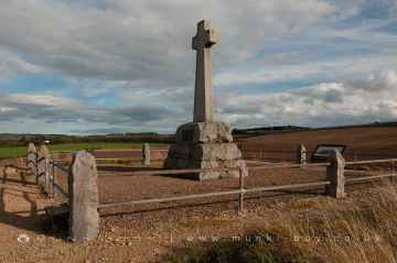
There are a several good historic monuments in the area around Blyth like Flodden.
Places near Blyth feature a number of interesting ancient sites including Milfield North Henge.
There are a several good geological features in the Blyth area like Gull Crag and the Rumble Churn, Greymare Rock, and Sycamore Gap.
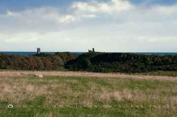
The area close to Blyth boasts some of the best castles including Dunstanburgh Castle.
Don't miss Dunstanburgh Castle, WWII Sandbag Pillbox, and Old Limekiln at Dunstanburgh's ruins if visiting the area around Blyth.
Blyth has some unmissable roman sites nearby like Hadrian's Wall near Hexham, and Chesters Roman Fort.
Blyth History
There are some historic monuments around Blyth:
Places to see near Blyth


History of Blyth
Between the 12th and 18th centuries, there were several small settlements and some industrial activity in the area. The principal industries during this period were coal mining, fishing and the salt trade. Shipbuilding in the area dates from 1748. The modern town of Blyth began to develop in the first quarter of the 18th century. Up until 1716, the land around the Blyth arethe Newsham Estatwas owned by the Earls of Derwentwater, but when the third Earl, James Radclyffe, was executed for his part in the Jacobite rising of 1715, the land was forfeited to the crown. On 11 July 1723, the Lordship of Newsham was put up for sale by the Commissioners of Forfeited Estates at their office in the Inner Temple, London. The land was bought by Matthew White and his brother-in-law Richard Ridley. From the 12th century, most port activities were on the north side of the river, but under White and Ridley the first new quays and houses were built on the south side, and from here the port began to prosper. By 1730, a coaling quay, a ballast quay, a pilots’ watch house and a lighthouse had all been built at Blyth harbour. In 1765 the first breakwater was constructed, and in 1788 the first staith with an elevated loading point was erected. Deep mines were sunk at Cowpen Colliery and Cowpen Square in 1796 and 1804 respectively, and by 1855, a quarter of a million tons of coal was being shipped from Blyth, rising to three million tons by 1900. The only industry not to survive during this prosperous time was the salt trade, which was heavily taxed during the 18th and early-19th centuries. During the Napoleonic Wars, the tax was increased to provide funds for the military and, even though the tax was abolished in 1825, the industry went into terminal decline. Having had fourteen salt pans at the beginning of the 18th century, exporting over 1,000 tons of salt annually, Blyth’s salt industry closed in 1876, with the destruction of the last salt pan. From the mid-19th century, several important events occurred which allowed the port of Blyth to rapidly expand. First, in 1847, a railway line was constructed, connecting Blyth to collieries at Seghill. This line combined with the existing line between Seghill and North Tyneside to form the Blyth and Tyne Railway. In 1853, the Blyth Harbour and Docks Board was formed, then in 1858 the Harbour Act was passed allowing dredging of the harbour to begin. In 1882, the formation of the Blyth Harbour Commission led to the building of new coal loading staiths, as well as the construction of the South Harbour.


