


Damerham
Damerham is a Town in the county of Hampshire.
There are great places to visit near Damerham including some great cities, villages, lakes, towns, historic buildings, shopping centres and airports.
There are a number of cities near Damerham including Portsmouth, and Winchester.
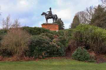
Damerham's best nearby villages can be found at Southwick, Milford-on-Sea, and Hambledon.
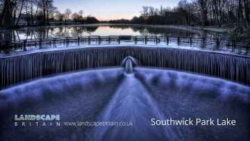
Don't miss Southwick Park Lake's lakes if visiting the area around Damerham.
Towns to visit near Damerham include Aldershot, Lymington, Gosport, Basingstoke, and Southampton.
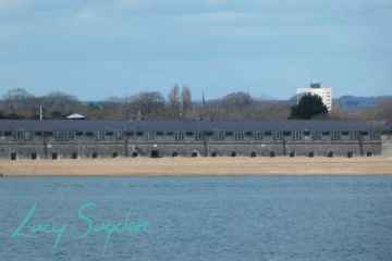
There are a number of historic buildings near to Damerham including Fort Blockhouse.
Shopping Centres to visit near Damerham include The Malls - Basingstoke, and Westquay.
Southampton Airport, and Blackbushe Airport are great places to visit near Damerham if you like airports.
Damerham History
There are some historic monuments around Damerham:
- Knighton Hill earthwork
- Two bowl barrows on Mount Ararat, 865m and 910m north east of Stephen's Castle
- Barrow W of village
- Rockbourne Down, Spring Pond enclosure
- Barrows in Salisbury Plantation
- Barrows N of St Giles Park
- A linear earthwork and two bowl barrows east of Bokerley Dyke on Blagdon Hill
- Bowl barrow 330m north of Grim's Ditch, near Tidpit Common
- Long barrow 700m west of Bride's Farm
- Long barrow in Round Clump
- Knap barrow: a long barrow 900m west of Down Farm
- Bowl barrow on Redman's Hill 450m south west of Bridge Farm
- Grans barrow: a long barrow 880m west of Down Farm
- Whitsbury hillfort
- Four bowl barrows 865m north east of Squirrel's Corner
- Penbury Knoll camp on Pentridge Hill
- Bowl barrow on Pistle Down, 800m north east of Burrows Farm
- Rockbourne Roman villa
- Knighton Roman road (stretching from Reddish Gore to reservoir)
- Two bowl barrows in Plumley Wood, 800m and 850m south of decoy pond, on Cranborne Common
- Bowl barrow 520m south of Ordnance Survey triangulation pillar in Ringwood Forest
- Bowl barrow 620m south of Ordnance Survey triangulation pillar in Ringwood Forest
- Faulston pigeon house
- Clearbury Ring
- Round barrow 860yds (786m) SE of Knighton Hill Buildings
- Odstock Copse earthwork
- Long barrow 3/4 mile (1200m) SW of St Rumbold's Church
- Barrow on Pentridge Down
- Medieval manorial buildings (uninhabited parts)
- Bowl barrow on Ashley Heath, 510m south east of Duncombe Lodge
- Two linear earthworks, two barrows and Iron Age and Romano-British settlements on Tidpit Common Down
- Grim's Ditch
- Bury Orchard ditch
- Long barrow 700m north-west of Tenantry Farm
- Wick Down round barrow
- The Giant's Grave long barrow
- Bowl barrow in Plumley Wood, 630m east of decoy pond, on Cranborne Common
- Long barrows and group of round barrows on Bokerly Down
- Bowl barrow 350m east of the shoulder angle of Bokerley Dyke on Martin Down
- A linear earthwork north east of West Woodyates Manor: part of the `Bokerley Line'
- Vernditch Chase long barrow
- Bowl barrow 210m north east of the junction of Grim's Ditch and Bokerley Dyke on Blagdon Hill
- Bowl barrow 290m north east of the junction of Bokerley Dyke and a linear earthwork on Martin Down
- Bowl barrow 250m north east of Monmouth's Ash Farm
- Round barrow cemetery and two associated enclosures, 550m west of Wimborne Lodge, associated with the Knowlton Circles
- Knighton Hill round barrow
- Two bowl barrows 445m south-west of Ordnance Survey triangulation pillar in Ringwood Forest
- Bowl barrow 90m north east of Monmouth's Ash Farm
- Two bowl barrows 200m north of Grim's Ditch, near Tidpit Common
- Knoll Camp hillfort, cross dyke, linear earthwork and hollow ways near Damerham Knoll
- Fordingbridge Bridge
- Croucheston Down Barn round barrow
- Bowl barrow 230m north east of Ebblake Bridge
- Ring ditch on Blackheath Down 650m south west of North Allenford Farm
- Bowl barrow 520m north east of the shoulder angle of Bokerley Dyke on Martin Down
- Round barrow cemetery south of New Barn Farm, associated with the Knowlton Circles
- Bowl barrow on Mount Ararat, 550m east of Burrows Farm
- Long barrow on Little Toyd Down, 760m south west of Grims Lodge Farm
- Soldier's Ring
- Length of deer park bank and ditch at Alderholt
- Two bowl barrows in Watchmoor Wood 270m and 290m south west of Ashley Lodge
- Duck's Nest: a long barrow on Rockbourne Down
- Oval barrow on Pistle Down, 1010m north east of Stephen's Castle
- Field system on Stoke Down
- Bokerley Dyke, and a section of Grim's Ditch, a section of a medieval boundary bank, and two bowl barrows on and north west of Martin Down
- Boundary banks on Rye Hill and in Maldry Wood
- Castle mound (or Castle Hill)
- Potteries at Prairie Farm
- Long barrow 600yds (550m) SE of Vanity
- Bowl barrow 270m north of Grim's Ditch, near Tidpit Common
- Bronze Age and Romano-British enclosure on Martin Down, east of Bokerley Junction
- Mizmaze on Breamore Down
- Roman road north east of Vernditch Chase: part of the Roman road between Sorviodunum (Old Sarum) and Vindocladia (Badbury)
- Clearbury Down round barrow
- Bowl barrow 120m north east of the junction of Grim's Ditch and Bokerley Dyke on Blagdon Hill
- St Michael's Priory
- Three associated linear earthworks on Martin Down
- Packhorse bridge
- Stephen's Castle, a bowl barrow 720m east of Eastworth Farm
- Knowle Hill round barrow
- Bowl barrow 90m south west of Reservoir Cottage
- Long barrow south-west of Vernditch Chase
- Barrow 30yds (27m) E of Dorset Cursus
- Marleycombe Hill earthworks
- Two sections of a linear earthwork north of West Woodyates Manor: part of the `Bokerley Line'
- Long Barrow 800m north-west of Paradise
- Giant's Grave: a long barrow 400m north-west of Down Farm
- Bowl barrow on the eastern part of Ashley Heath, 660m north west of Ashley Lodge
- Part of Dorset Cursus
- Two round barrows S of Cranborne Farm
- Two linear earthworks in Vernditch Chase
- Two bowl barrows in Plumley Wood, 1020m and 1060m south east of decoy pond, on Cranborne Common
- Bowl barrow on Little Toyd Down, 650m south west of Grims Lodge Farm
- Grim's Ditch: Old Lodge Copse to Toyd Clump
- Bowl barrow on Homington Down, 725m south of Tottens Farm
- Three adjoining linear earthworks and three bowl barrows north of Bokerley Dyke on Martin Down
- Camp at Nine Yews
- Earthworks S of Knighton Hill Buildings
- Celtic fields on Pentridge Down
- Bowl barrow 45m south west of Bowldish Pond
- Bowl barrow 240m north east of Martin's Farm Bungalow
- Barrows in and near St Giles Park
- Roman road along the south side of Vernditch Chase: part of the Roman road between Sorviodunum (Old Sarum) and Vindocladia (Badbury)
- Bowl barrow cemetery and a cross dyke on Horton Common 800m south of Bridge Farm
- Sandalholme pottery works
Places to see near Damerham


Lakes near Damerham
Canals near Damerham
Rivers near Damerham
- Teffont
- Hampshire Avon (Upper) d/s Nine Mile River confl
- Nadder Trib (Swallowcliffe)
- Nadder (Middle)
- Linford Brook
- Hampshire Avon (Upper) u/s Nine Mile River confl
- Ripley Brook
- Ebble (Upper)
- Till (Hampshire Avon)
- Nadder (Headwaters)
- Clockhouse Stream
- Bisterne Stream
- Bourne (Hampshire Avon)
- Sem
- Ashford Water (Allen River)
- Etchilhampton Water
- Nine Mile River
- Wylye (Headwaters)
- Wylye (Middle)
- Wylye Trib (The Were or Swan)
- Ebble
- Ditchend Brook
- Hampshire Avon (West)
- Mude
- Chitterne Brook
- Nadder (Upper)
- Nadder (Lower)
- Sweatfords Water
- Wylye Trib (Heytesbury Stream)
- Hampshire Avon (East) and Woodborough Stream
- Huckles Brook
- Dockens Water
- Sleep Brook
- Hampshire Avon (Lower)
- Fonthill Stream
- Wylye (Lower)
- Hampshire Avon (East) and Deane Water
- Fovant Brook
- Penwood Stream
- Enborne (downstream A34 to Burghclere Brook)
- Lower Enborne
- Middle Kennet (Marlborough to Hungerford)
- Shalbourne (source to Kennet at Hungerford)
- Kingsclere Brook (Source to Enborne)
- Inkpen Stream (source to Kennet)
- Holy Brook
- Earlstone Stream and Burghclere Brook (source to Enborne)
- Winterbourne
- Froxfield Stream
- Clayhill Brook
- Enborne (Burghclere Brook to Kingsclere Brook)
- Upper Dun
- Og
- Kennet (Lambourn confluence to Enborne confluence)
- Kennet and Holy Brook
- Middle Kennet (Hungerford to Newbury)
- Upper Kennet to Marlborough
- Burghfield Brook
- Aldbourne
- Baughurst Brook
- West End Brook (tributary of Foudry Brook)
- Silchester Brook
- Lambourn (Source to Newbury)
- Enborne (Source to downstream A34)
- Foudry Brook (West End Brook to M4)
- Kennet and Avon Canal and Dun above Hungerford
- Ecchinswell Brook (source to Enborne)
- Vyne Stream
- Hart (Elvetham to Hartley Wintney)
- Cove Brook
- Whitewater
- Loddon (Swallowfield to River Thames confluence)
- Barkham Brook
- Loddon (Sherfield on Loddon to Swallowfield)
- Blackwater (Aldershot to Cove Brook confluence at Hawley)
- Blackwater (Bramshill to River Loddon confluence at Swallowfield)
- Emm Brook
- Blackwater (Hawley to Whitewater confluence at Bramshill)
- Fleet Brook
- Lyde
- Hart (Crondall to Elvetham)
- Bow Brook (Bramley to Sherfield Green)
- Twyford Brook
- Loddon (Basingstoke to River Lyde confluence at Hartley Wespall)
- Bow Brook (Pamber End to Bramley)
- Loddon (Hartley Wespall to Sherfield on Loddon)
- Domsey Brook
- Virley Brook
- Blackwater (Combined Essex)
- Pant
- Brain


