


Bank
Bank is a Village in the county of Hampshire.
Bank postcode: SO43 7FD
There are great places to visit near Bank including some great cities, villages, lakes, towns, historic buildings, shopping centres and airports.
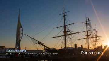
Portsmouth, and Winchester are great places to visit near Bank if you like cities.
There are a number of villages near Bank including Southwick, Milford-on-Sea, and Hambledon.
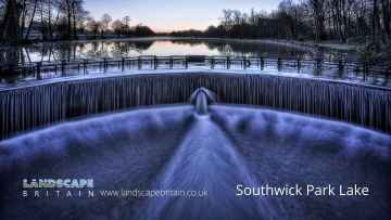
There are a number of lakes near to Bank including Southwick Park Lake.
There are a number of towns near Bank including Aldershot, Lymington, Gosport, Basingstoke, and Southampton.
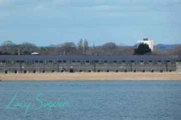
Places near Bank feature a number of interesting historic buildings including Fort Blockhouse.
There are a several good shopping centres in the Bank area like The Malls - Basingstoke, and Westquay.
The area around Bank boasts some of the best airports including Southampton Airport, and Blackbushe Airport.
Bank History
There are some historic monuments around Bank:
- Bowl barrow 230m WNW of Wilverley Post
- Bowl barrow north of Fulliford Bog
- Two fancy barrows on Setley Plain
- Bowl barrow south of Fulliford Bog
- Two superimposed bowl barrows 600m south of Stockley Cottage
- Bowl barrow 860m east of Dilton Farm forming part of the Beaulieu Airfield round barrow cemetery
- Bell barrow and two bowl barrows 180m south west of Stagbury Hill, Furzley Common
- Bowl barrow 500m north of Longcross Pond forming part of Black Bush Plain round barrow cemetery
- Two bowl barrows forming part of Bratley Plain round barrow cemetery
- Two bowl barrows 400m north-west of Janesmoor Pond
- Two bowl barrows 940m north of Longcross Pond forming part of Black Bush Plain round barrow cemetery
- Bowl barrow at Shirley Holms, 630m north-east of Little Purley Farm
- Cold Pixie's Cave: a bowl barrow 600m south-east of Stockley Cottage
- Rabbit warren and four bowl barrows on Stagbury Hill, Furzley Common
- Bowl barrow 650m north-east of Little Dilton Farm forming part of Beaulieu Airfield round barrow cemetery
- Tatchbury Mount hillfort
- Bowl barrow 770m north of Longcross Pond forming part of Black Bush Plain round barrow cemetery
- Seven bowl barrows forming part of Bratley Plain round barrow cemetery
- Bowl barrow and associated enclosure 430m north of Longcross Pond forming part of Black Bush Plain round barrow cemetery
- Bowl barrow 980m north-west of Wilverley Post
- Two bowl barrows and a bell barrow on Matley Heath
- Bowl barrow 500m north of Williford Cottages
- Medieval hunting lodge in Churchplace Inclosure
- Park pale known as Bishop's Dyke, and a Bronze Age bowl barrow, to the south and west of Furzy Brow
- Bowl barrow at Shirley Holms, 640m east-north-east of Little Purley Farm
- Fancy barrow 500m north-east of Little Dilton Farm forming part of the Beaulieu Airfield round barrow cemetery
- Hillfort at Buckland Rings
- Fancy barrow on Race Plain
- Medieval hunting lodge at Church Place
- Bowl barrow 660m east of Dilton Farm.
- Bowl barrow 300m south-east of Church Place
- Studley Castle royal hunting lodge
- Risbury Hill round barrows
- Bowl barrow 250m south of Two Bridges Bottom
- Bowl barrow 675m north of Longcross Pond forming part of Black Bush Plain round barrow cemetery
- Bowl barrow forming part of Bratley Plain round barrow cemetery
- Bowl barrow 350m south-east of Church Place
- Bowl barrow on Hiscocks Hill
- Two bowl barrows 660m north-east of Little Dilton Farm forming part of Beaulieu Airfield round barrow cemetery
- Hillfort 400m south of Home Farm
- Bowl barrow 545m north of Longcross Pond forming part of Black Bush Plain round barrow cemetery
- Two round barrows south of Ferny Knap Inclosure
- Bowl barrow on Wilverley Plain
- Bowl barrow in Mallard Wood
- Money Hills round barrows
- Bowl barrow 940m east of Dilton Farm forming part of Beaulieu Airfield round barrow cemetery
- Bowl barrow 720m north of Longcross Pond forming part of Black Bush Plain round barrow cemetery
- Bowl barrow on eastern edge of Mallard Wood
- Malwood Castle hillfort
- Bowl barrow 620m north east of the Lodge
- Five bowl barrows 500m north of Longcross Pond forming part of the Black Bush Plain round barrow cemetery
- Bowl barrow 660m east of Church Place
- Bowl barrow at Matley Holms
- Bowl barrow 500m west of Norley Inclosure
- Bowl barrow at Longwater Lawn
- Bowl barrow 1130m east of Broomy Lodge
- Bowl barrow 800m west of Marlpit Oak
- Two bowl barrows forming part of Bratley Plain round barrow cemetery
- Bowl barrow 645m north of Longcross Pond forming part of Black Bush Plain round barrow cemetery
- Bowl barrow forming part of Bratley Plain round barrow cemetery
- Bowl barrow at Fulliford Passage
- Bowl barrow 340m north-west of Wilverley Post
- Three bowl barrows 720m south-west of Beaulieu Road Station
- Two bowl barrows in the Bishop of Winchester's Purlieu
- Moated site and two fishponds 300m west of Moorcourt
- Bell barrow 900m north-west of Wilverley Post
- Fancy barrow on Setley Plain
- Two bowl barrows in Hawkhill Inclosure
- Bowl barrow 400m north-west of Ober Corner
- Bowl barrow at Shirley Holms, 660m east-north-east of Little Purley Farm
- Bowl barrow 400m north-west of Norley Inclosure
- Bowl barrow 515m north of Longcross Pond forming part of Black Bush Plain round barrow cemetery
- Three bowl barrows 620m east of Dilton Farm
- Bowl barrow 400m south-west of Robin Hood Farm
- Bowl barrow at Woodfidley Passage
- Twin bowl barrow on Furzley Common, 810m SSW of Stagbury Hill
- Bowl barrow 280m WNW of Wilverley Post
- Bowl barrow 820m north-east of Dilton Farm
- Bell barrow at Shirley Holms, 710m east-north-east of Little Purley Farm
- Two bowl barrows east of Church Place
- Bowl barrow in the Bishop of Winchester's Purlieu
- Medieval hunting lodge in Queen Bower
- Bowl barrow forming part of Bratley Plain round barrow cemetery
- Bowl barrow 125m south-west of Stockley Inclosure
- Four bowl barrows west of Breamore Hat
- Bowl barrow 800m east of Dilton Farm forming part of Beaulieu Airfield round barrow cemetery
- Two bowl barrows 460m north-west of Norley Inclosure
- Bowl barrow 640m north-east of Little Dilton Farm forming part of Beaulieu Airfield round barrow cemetery
- Roman pottery kilns at Island Thorns Enclosure
- Three bowl barrows forming part of Bratley Plain round barrow cemetery
- Two bowl barrows 680m south-west of Beaulieu Road Station
- Bowl barrow west of Holmhill Bog
- Bowl barrow 320m west of Ober House
- Bowl barrow 1118m east of Broomy Lodge
Places to see near Bank

Lakes near Bank
Canals near Bank
Rivers near Bank
- Teffont
- Hampshire Avon (Upper) d/s Nine Mile River confl
- Nadder Trib (Swallowcliffe)
- Nadder (Middle)
- Linford Brook
- Hampshire Avon (Upper) u/s Nine Mile River confl
- Ripley Brook
- Ebble (Upper)
- Till (Hampshire Avon)
- Nadder (Headwaters)
- Clockhouse Stream
- Bisterne Stream
- Bourne (Hampshire Avon)
- Sem
- Ashford Water (Allen River)
- Etchilhampton Water
- Nine Mile River
- Wylye (Headwaters)
- Wylye (Middle)
- Wylye Trib (The Were or Swan)
- Ebble
- Ditchend Brook
- Hampshire Avon (West)
- Mude
- Chitterne Brook
- Nadder (Upper)
- Nadder (Lower)
- Sweatfords Water
- Wylye Trib (Heytesbury Stream)
- Hampshire Avon (East) and Woodborough Stream
- Huckles Brook
- Dockens Water
- Sleep Brook
- Hampshire Avon (Lower)
- Fonthill Stream
- Wylye (Lower)
- Hampshire Avon (East) and Deane Water
- Fovant Brook
- Penwood Stream
- Enborne (downstream A34 to Burghclere Brook)
- Lower Enborne
- Middle Kennet (Marlborough to Hungerford)
- Shalbourne (source to Kennet at Hungerford)
- Kingsclere Brook (Source to Enborne)
- Inkpen Stream (source to Kennet)
- Holy Brook
- Earlstone Stream and Burghclere Brook (source to Enborne)
- Winterbourne
- Froxfield Stream
- Clayhill Brook
- Enborne (Burghclere Brook to Kingsclere Brook)
- Upper Dun
- Og
- Kennet (Lambourn confluence to Enborne confluence)
- Kennet and Holy Brook
- Middle Kennet (Hungerford to Newbury)
- Upper Kennet to Marlborough
- Burghfield Brook
- Aldbourne
- Baughurst Brook
- West End Brook (tributary of Foudry Brook)
- Silchester Brook
- Lambourn (Source to Newbury)
- Enborne (Source to downstream A34)
- Foudry Brook (West End Brook to M4)
- Kennet and Avon Canal and Dun above Hungerford
- Ecchinswell Brook (source to Enborne)
- Vyne Stream
- Hart (Elvetham to Hartley Wintney)
- Cove Brook
- Whitewater
- Loddon (Swallowfield to River Thames confluence)
- Barkham Brook
- Loddon (Sherfield on Loddon to Swallowfield)
- Blackwater (Aldershot to Cove Brook confluence at Hawley)
- Blackwater (Bramshill to River Loddon confluence at Swallowfield)
- Emm Brook
- Blackwater (Hawley to Whitewater confluence at Bramshill)
- Fleet Brook
- Lyde
- Hart (Crondall to Elvetham)
- Bow Brook (Bramley to Sherfield Green)
- Twyford Brook
- Loddon (Basingstoke to River Lyde confluence at Hartley Wespall)
- Bow Brook (Pamber End to Bramley)
- Loddon (Hartley Wespall to Sherfield on Loddon)
- Domsey Brook
- Virley Brook
- Blackwater (Combined Essex)
- Pant
- Brain


