Pentre Gwynfryn
Pentre Gwynfryn is a Village in the county of Gwynedd.
Pentre Gwynfryn postcode: LL45 2LU
There are great places to visit near Pentre Gwynfryn including some great towns, ancient sites, mountains, lakes, historic monuments, old mines and ruins.
Pentre Gwynfryn's best nearby towns can be found at Pwllheli, and Barmouth.
Pentre Gwynfryn is near some unmissable ancient sites like St. Cybi's Well,
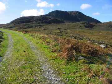
The area around Pentre Gwynfryn boasts some of the best mountains including Y Garn, Arenig Fawr, Snowdon, and Cnicht.
The area around Pentre Gwynfryn features a number of interesting lakes including Llyn Ogwen, and Llyn Arenig fawr.
Places near Pentre Gwynfryn feature a number of interesting historic monuments including Arenig Fawr.
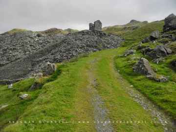
Places near Pentre Gwynfryn feature a number of interesting old mines including Croesor Quarry.
There are a number of ruins near to Pentre Gwynfryn including Croesor Quarry.
Pentre Gwynfryn History
There are some historic monuments around Pentre Gwynfryn:
- Enclosed Hut Group in Parc-y-Borth
- Muriau'r Gwyddelod Ancient Village
- Byrllysg promontory fort
- Inscribed Stone in Llanfihangel Traethau Churchyard
- Cors-y-Gedol Burial Chamber
- Coety Mawr Round Hut and Enclosure
- Hut Circle Settlement East of Caer-Cynog
- Llyn Eiddew Bach Ring Cairn II
- Standing Stone S of Cerrig-y-Cledd
- Maes y Caerau Homestead
- Hut Circle South of Tyddyn-Du
- Settlement 400m SE of Moel Goedog
- Cefnfilltir Enclosed Homestead
- Hut Circle Settlement at Bwlch Tyddiad
- Llecheiddior Round Cairns
- Eithin-Fynydd Platform House Settlement
- Ffridd Fedw Round Hut, Enclosure, Ancient Fields and Kerb Cairn
- Pont Scethin
- Hut Circles East of Moel Geifr
- Bedd Gorfal Ring Cairn
- Settlement E of Eisingrug
- Craig-y-Ddinas Camp
- Ffridd Fron Kerb Cairn
- Moel y Glo Homestead & Burnt Mound
- Pen y Dinas Cairn
- Llyn Eiddew Bach Ring Cairn I
- Llyn Eiddew Bach Round Cairns
- Hengwm Stone Circles
- Enclosure and Early Field System North of Fronhill, Llanfair
- Hut Circle Settlement North-East of Moel-y-Gerddi
- Llidiart-Garw Platform House and Paddock
- Fortified Settlement at Bryn Castell
- Cwm Moch Settlement
- Garreg Round Cairn
- Settlement 500m SE of Moel Goedog
- Deserted Rural Settlement North of Llyn y Fedw
- Enclosure near Bron y Foel, Moelfre
- Ceunant Egryn Hut Group
- Hut Group and Enclosures on SW Slope of Moelfre
- Hut Circle West of Pen-y-Bryn
- Cist Cerrig Burial Chamber & Cup Marked Rock
- Fonlief Hir Standing Stones
- Bryn Cader-Faner Round Cairn
- Bwlch y Rhiwgyr cairn
- Enclosed Hut Circle Settlement and Long huts E of Egryn Abbey
- Hengaeau Standing Stone
- Cerrig Arthur Stone Circle
- Fron-Galed Homestead
- Bwlch y Rhiwgyr, cairn 350m to SW of
- Clogwyn Arllef Hillfort & Field System
- Llecheiddior Stone Circle
- Settlement & Fields Systems above Egryn Abbey
- Hut Circle Settlement and Cairn Field West of Llyn Eiddew Bach
- Harlech Castle
- Llwyn du Parc cairn
- Berth Ddu Hut Circles
- Moel Goedog Round Cairns & Standing Stones
- Ffridd Fechan Fort
- Mynydd Egryn Ring Cairn
- Lockheed P-38 Lightning Aircraft, Intertidal zone, Morfa Harlech
- Enclosed Hut Circle North of Tyddyn Mawr
- Hut Circle at Gellfawr
- Deserted Rural Settlement South of Ffridd Olchfa
- Dyffryn Burial Chamber
- Medieval Ecclesiastical Structure SE of Ty'n y Coed Cottage
- Cors-y-Gedol Settlements & Field System
- Bron-y-Foel West Burial Chamber
- Erw Wen Prehistoric and Medieval Settlement
- Enclosed Hut Circle Settlement South East of Yr Onen
- Settlement and Field System at Bron y Foel Uchaf
- Carneddau Hengwm Long Cairns
- Settlements SW of Bryn Cader Faner
- Tyddyn Sion Wyn Ring Cairn
- Y Gyrn Round Cairns
- Tyddyn Du Enclosed Settlement
- Moel Goedog Camp
- Hut Circle near Gerddi Bluog
- Pont Llanbedr
- Hut Circle North-East of Moel Goedog
- Llanbedr Standing Stones
- Groes Las Prehistoric Settlement & Field System
- Brwyn-Llynau Enclosed Settlement
- Pen y Ddinas Camp
- Ceunant Egryn Enclosed Settlement
- Hut Circle West of Merthyr Farm
- Coety Bach Homestead
- Gwern Einion Burial Chamber
- Mynydd Egryn Settlement