


Didworthy
Didworthy is a Village in the county of Devon.
Didworthy postcode: TQ10 9EF
There are great places to visit near Didworthy including some great cities, historic buildings, villages, canals, rivers and streams, beaches, geological features, sssis, hiking areas, nature reserves, towns, parks, airports, castles and ruins.
Places near Didworthy feature a number of interesting cities including Exeter.
Historic Buildings to visit near Didworthy include Exeter Cathedral, St Mary Steps, and St Stephen's Church - Exeter.
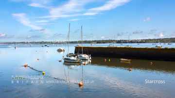
The area around Didworthy features a number of interesting villages including Starcross, Lynton and Lynmouth, Littleham, Otterton, Branscombe, Beer, and Hope Cove.
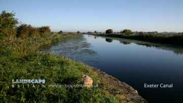
Didworthy's best nearby canals can be found at Exeter Canal, and Grand Western Canal at Tiverton.
The area close to Didworthy boasts some of the best rivers and streams including East Lyn River.
There are a several good beaches in the Didworthy area like Blacklands Beach, Branscombe Beach, and Hope Cove.
Valley of Rocks is a great place to visit close to Didworthy if you like geological features.
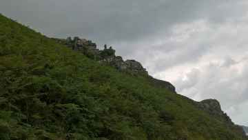
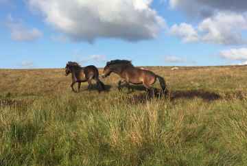
There are a number of sssis near to Didworthy including Dartmoor.
Places near Didworthy feature a number of interesting hiking areas including Dartmoor.
Dartmoor is a great place to visit close to Didworthy if you like nature reserves.
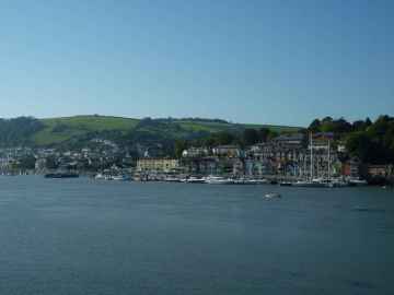
Towns to visit near Didworthy include Dartmouth, Tiverton, Crediton, Topsham, Budleigh Salterton, Sidmouth, and Seaton.
There are a number of parks near to Didworthy including Bicton Park.
Didworthy is near some unmissable airports like Exeter Airport,
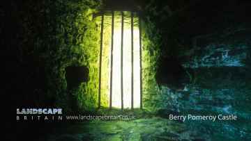
Berry Pomeroy Castle is a great place to visit close to Didworthy if you like castles.
There are a several good ruins in the area around Didworthy like Berry Pomeroy Castle.
Didworthy History
There are some historic monuments around Didworthy:
- Multiple stone alignment and associated cairns west of Glasscombe Upper Plantation
- Unenclosed stone hut settlement with enclosures north of Piles Copse
- Partially enclosed stone hut circle settlement 420m north west and 440m west of Horn's Cross
- One of several stone hut circles north of Corringdon Ball
- Blackdown Rings prehistoric hillfort and medieval castle
- Earthworks in Boro' Wood
- Cairn north-east of Harrowthorn Plantation
- Eastern White Barrow
- Knatta Barrow
- Enclosed prehistoric settlement and round cairn 880m south west of Venford Reservoir dam
- Stone hut circle on Corringdon Ball
- Stone alignment north of Glasscombe Upper Plantation
- Ring cairn on Holne Moor 430m south west of Seale's Stoke
- One of two stone hut circles on Corringdon Ball, north of Corringdon Farm
- Cairn north of Glasscombe Ball
- Cairn on Piles Hill
- Animal pound and enclosure 220m and 120m south west of High Marks Barn
- Glaze Meet blowing house (Tinner's Foundry)
- Cairn with a cist on the eastern slope of Brent Fore Hill
- Pound at Newbridge
- Riders Rings (The Rings)
- Agglomerated enclosure on the west side of the Erme Valley below Stalldown
- Stone alignment and cairn south-east of Western Beacon
- Hut circles in Erme Valley
- Hillson's House cairn, Stalldown
- Enclosure with hut circles north of Scad Brook
- Enclosure with hut circles to the north-east of Piles Copse
- Wayside cross 1120m ENE of Childe's Tomb
- Unenclosed stone hut settlement on the east side of the Erme Valley, north Harford Moor
- Prehistoric stone hut circle settlement, a contemporary field system, post-medieval buildings and two lengths of leat 310m south east of Yealm Steps
- Agglomerated enclosure with hut circles on Corringdon Ball
- Stone alignment and two cairns to the north-west of Glasscombe Ball
- Wayside cross on Down Ridge 730m south west of Saddle Bridge
- Stone hut circle and length of boundary walling 860m south west of Venford Reservoir dam
- The middle one of three stone hut circles south west of Corringdon Leat, Corringdon Ball
- Enclosure SE of Dockwell Hole
- Prehistoric fields, settlements and cairn south east of Venford Reservoir forming part of the Dartmeet coaxial field system
- Long cairn east of Butterdon Hill
- Sherberton stone circle 315m SSE of Little Sherberton
- Cross NE of Nun's Cross
- Stone alignment and terminal cairns south-west of Glasscombe Corner
- Cairn north-west of Butterdon Hill
- Cairn NW of Beacon Plain
- Stone row, cairn and enclosures near Hook Lane, Erme Valley
- Holne Chase Castle
- Butterdon Hill stone alignment and cairn
- Cairn near summit of Ugborough Beacon
- Cairn to the west of Tristis Rock, Burford Down
- Stone cross on Ter Hill
- Stone alignment and retaining kerb on Burford Down
- Stone hut circle on Down Ridge 480m south west of Saddle Bridge
- Round cairn 580m south of Horn's Cross forming part of a cairn cemetery on Holne Ridge
- Ringwork and bailey castle 400m south of Langford Barton
- Down Ridge stone circle and outlying standing stone 570m and 650m south of Forest Inn
- Three enclosed hut groups, Black Tor, Shipley Bridge
- Enclosures and hut circles at Petre's Pits Bottom
- Round barrow NW of Harbourneford
- Enclosure and hut circles at junction of Blatchford Bottom and River Erme
- Enclosure with hut circles and rectangular pens, south of Bala Brook
- One of a group of four cairns on Butterdon Hill
- Spurrell's Cross
- Dovecote 100m north of Pridhamsleigh
- Round cairn on the summit of Great Gnat's Head
- One of a group of four cairns on Butterdon Hill
- Enclosure and hut circle N of Old Hill
- Two hut circles on the south-east slope of Stalldown
- Group of three closely spaced cairns on the south-western brow of Western Beacon
- Stone alignment on Piles Hill
- Cairn south of Stalldown stone alignment
- Ringleshutes tinwork
- Part of the Dartmeet coaxial field system and other archaeological remains on Holne Moor west and north west of Venford Reservoir
- Four cairns on Holne Lee 1140m north west of Greatcombe
- Cairn on Sharp Tor
- Enclosure east of an agglomerated enclosure south-east of Yealm Steps
- Cairn near Ball Gate, Corringdon Ball
- Cairn NNW of Beacon Plain
- Enclosure with hut circles north of Bala Brook intake
- Cairn in north-east corner of Lower Piles
- Round Barrow on Dendles Waste (Kerbed cairn with cist in Dendles Waste, 920m SSW of Yealm Steps)
- Cairn on northern Harford Moor
- Spurrell's Cross stone alignment and cairn.
- Enclosure with hut circles north of Corringdon Ball
- Hillfort on Brent Hill
- Blowing houses at Week Ford
- Enclosed prehistoric settlement and three round cairns 870m south east of Horn's Cross
- One of a group of four cairns on Butterdon Hill
- The North Gate and part of the precinct area of Buckfast Abbey
- One of a number of cairns at Black Pool
- Cist east of Hangershell Rock
- Enclosure with hut circles west of Corringdon Leat, Corringdon Ball
- Enclosure on the west side of the Erme valley below Stalldown
- Hut circles and field systems E of Mel Tor
- Enclosure and hut circles E of Huntingdon Ford
- Three enclosed hut groups, Huntingdon Warren
- Agglomerated enclosure with hut circles, south of Lower Piles
- Hut circles and enclosure to S of Left Lake
- Cairn on Weatherdon Hill
- Enclosure with hut circles east of Addicombe
- Chambered cairn in Cuckoo Ball newtake
- Enclosure and hut circles in Erme Valley on east side of Stall Moor
- One of two cairns north-east of Harford Moor Gate
- One of several stone hut circles north of Corringdon Ball
- Cairn south-west of Spurrell's Cross, Ugborough Moor
- Cist and cairn 590m SSE of Skir Ford
- Enclosure and hut circles on Erme Plains E of River Erme
- Cist and retaining kerb south-east of Lower Piles
- Five stone hut circles 500m south east of Yealm Steps forming part of a large stone hut circle settlement
- Enclosure with hut circles north of Harrowthorn Plantation
- Five stone hut circles 320m east of Yealm Steps forming part of a large stone hut circle settlement
- Cairn near summit of Brent Fore Hill
- Cairn above the south-west bank of the East Glaze Brook
- Hut circles and two enclosures on Dean Moor, near River Avon
- Hut circle village 600yds (548m) SE of Swincombe
- Stall Moor circle and long stone row
- Cairn to the east of Hangershell Rock
- Hut circle 400yds (370m) SE of Swincombe
- Hawson Cross
- Two conjoined huts between two enclosures north of Bala Brook intake
- Cist 430m ESE of Yealm Steps
- Cairn with cist S of Royal Hill
- Enclosure with hut circles in Higher Piles newtake
- Cairn on the southern brow of Western Beacon
- Cairn above the south-west bank of the East Glaze Brook
- Two fallen standing stones east of Hangershell Rock
- One of a number of cairns at Black Pool
- Enclosure WSW of Dockwell Hole
- Blowing house on Down Ridge
- One of two cairns north-east of Harford Moor Gate
- Medieval farmstead and field system, post-medieval tinworks, prehistoric settlements and cairns north and west of Gibby Coombe
- The southern of three stone hut circles south west of Corringdon Leat, Corringdon Ball
- Partially enclosed stone hut circle settlement 350m south west of Horn's Cross
- One of a number of cairns at Black Pool
- Chambered cairn at Ball Gate, Corringdon Ball
- Unenclosed stone hut settlement north-east of Yadsworthy
- Bowl barrow on Churchland Green 350m west of Coldharbour Farm
- Cairn on Piles Hill
- Two cairns south-east of the stone alignment south-west of Glasscombe Corner
- Enclosure with hut circles north of Bala Brook intake
- Enclosure on Stalldown
- One of several cairns south-west of Spurrell's Cross, Ugborough Moor
- Western White Barrow
- Remains of chapel on Brent Hill
- Two hut circles on the right bank of Red Brook
- Wayside cross on Down Ridge 1.1km south west of Saddle Bridge
- Hut enclosure N of Old Hill
- Three stone hut circles 780m SSW of Venford Reservoir dam
- Cairn west of Ball Gate, Corringdon Ball
- Two cairns and a cist 300yds (270m) NW of Swincombe intake
- Four cairns 560m east of Hapstead Ford and 1660m east of Ryder's Hill, forming part of a cairn cemetery in the Mardle Valley
- Cairn on Glasscombe Ball
- Blowing house and mill at Gobbet
- Bowl barrow 660m south west of Woodland Barton
- Cairn S of Royal Hill
- Cairn east of the northern end of the stone alignment south-west of Glasscombe Corner
- Cairn on Eastern Beacon
- Stone alignment and cairns on Stalldown
- One of three cairns on Three Barrows, Ugborough Moor
- One of three cairns on Three Barrows, Ugborough Moor
- Hut circle and field system NW of Saddle Bridge
- Hut circles and field system SW of Combestone Wood
- Two ring cairns 330m south east of Coldharbour Cross
- Blowing house N of Yealm Steps
- One of a group of four cairns on Butterdon Hill
- Cairn on Piles Hill
- One of a number of cairns at Black Pool
- One of two stone hut circles on Corringdon Ball, north of Corringdon Farm
- Hut circle and fields, Bishop's Mead
- One of three cairns on Three Barrows, Ugborough Moor
- Blowing house N of Dry Lake
- Stone hut circle south west of Corringdon Ball
- Cairn near the summit of Western Beacon
- One of several cairns south-west of Spurrell's Cross
- Four cairns 310m south of Horn's Cross forming part of a cairn cemetery on Holne Ridge
- Cairn on Weatherdon Hill
- Ring cairn on Holne Ridge 860m north west of Hapstead Ford and 1180m north east of Ryder's Hill
- Unenclosed stone hut circle settlement west of Butter Brook Reservoir
- Cairn south-east of Lower Piles
- Enclosure with a hut circle on the west side of Corringdon Ball
- Stone hut circle east of Corringdon Leat, Corringdon Ball
- One of two stone hut circles north of Corringdon Leat, Corringdon Ball
- Three unenclosed stone hut circles on the west side of the Erme Valley, north of Lower Piles
- Hembury Castle
- Two cairns with cists E of Whiteworks tin mine buildings
- Prehistoric fields and settlements north east of Venford Reservoir forming part of the Dartmeet coaxial field system
- The northern of three stone hut circles south west of Corringdon Leat, Corringdon Ball
- Enclosure and hut circles on Erme Plains
- Two cairns on the south side of Ugborough Beacon
- Enclosure and hut circles at Piles Corner
- Partially enclosed stone hut circle settlement 560m west of Horn's Cross
- Cairn south-east of Higher Piles
- Cist with a retaining kerb north-west of Corringdon Ball
- Enclosure with hut circles west of Glasscombe Corner
- Cairn west of Stalldown
- Eight cairns forming part of a cairn cemetery on Holne Ridge and a stone alignment immediately west of Horn's Cross
- Stone hut circle west of Corringdon Leat, Corringdon Ball
- Two cairns at Ausewell Rocks
- Cairn cemetery 900m north east of Hapstead Ford and 2km WSW of Fore Stoke
- One of two stone hut circles north of Corringdon Leat, Corringdon Ball
- Horn's Cross
- Hilltop enclosure at Yellowberries Copse, 430m west of Higher Turtley
- Blowing house at junction of Hook Lake and River Erme
- Cairn south of Spurrell's Cross, Ugborough Moor
- Chapel E of parish church
- Hut circles in Erme Pound E of River Erme
- One of several stone hut circles north of Corringdon Ball
- Enclosure with hut circles east of Addicombe
Places to see near Didworthy


Lakes near Didworthy
Rivers near Didworthy
- Broughton Brook (South and West Somerset)
- Tributary of Back Stream (Tone Catchment)
- Hele Bk
- Tone - Wellington to Taunton
- Haywards Water
- Westford Stream
- Sherford Stream
- Tone - Upper
- Back Stream
- Halse WTR
- Allen Brook(Maiden brook)
- Hillfarrance Bk
- West Dart River (Lower)
- West Dart River (Upper)
- East Webburn River
- West Dart River (Blackbrook to Swincombe)
- Wash
- Ashburn
- East Dart River
- Hems - Upper
- West Webburn River
- Swincombe
- Avon (Devon Tidal) and Sth Hams - Blackpool
- Mardle
- Avon (Devon Tidal) and Sth Hams - Slapton
- Cherry Brook
- Hems - Lower
- Dean Burn
- Dart
- Dart (Tidal)
- Am Brook
- Webburn
- Bidwell Brook
- The Gara
- Blackbrook River
- Harbourne River
- Beadon Brook
- Lemon
- South Teign River
- Reedy Brook
- North Teign
- Fingle Brook
- Teign (Upper)
- Ugbrooke Stream
- Wray Brook
- Aller Brook (Teign) - Lower
- Kate Brook
- Scotley Brook
- Aller Brook (Teign) - Upper
- Middle Bovey
- Blackaton Brook
- Liverton Brook
- Aller Brook
- Sowton Brook
- Bramble Brook
- Lower Bovey
- Becka Brook
- Upper Bovey
- Teign (Lower)
- Sheepham Bk
- Ayleston Brook
- Lud Brook
- Lower Erme
- Erme
- Middle Barle
- Dart (Exe)
- Danes Brook
- Lower Batherm
- Upper Barle
- Exe (Haddeo to Barle)
- Burn (Exe)
- Iron Mill Stream
- Upper River Haddeo
- Upper Batherm
- Lowman
- Exe (Barle to Culm)
- North Brook (East Devon)
- Exe (Quarme to Haddeo)
- Calverleigh Stream
- Exe (Source to Quarme)
- Exe (Culm to Creedy)
- Exe (Creedy to Estuary)
- Lower Barle
- Ben Brook
- Ben Brook
- Brockey River
- Quarme
- Lower River Haddeo
- Pulham
- Sherdon Water
- Grindle Brook
- Bolham River
- Weaver
- Aylesbeare Stream
- Polly Brook
- Halberton Stream
- Fulford Water
- Lower Clyst
- Madford River
- Ken Stream
- Middle Culm
- Lower Cranny Brook
- Ford Stream (EXE)
- Spratford Stream
- Upper Clyst
- Sheldon Stream
- Upper Cranny Brook
- Upper Culm
- Lower Culm
- Kenn
- Colebrook
- Holly Water
- Alphin Brook
- Lower Yeo (Creedy)
- Matford Brook
- Ford Brook (EXE)
- Upper Creedy
- Dawlish Water
- Upper Yeo (Creedy)
- Jackmoor Brook
- Shobrooke Lake
- Lower Creedy
- Troney
- Middle Creedy
- Culvery River
- Lim
- Branscombe Stream
- Blackwater River
- Lower Axe
- Kit Brook
- Yarty
- Umborne Brook
- Upper Coly
- Upper Axe
- Offwell Brook
- Lower Coly
- Forton Brook
- Corry Brook
- West Lyn River
- Heddon
- Lower East Lyn River
- Mully Brook
- Rye Stream
- Upper East Lyn River
- Lower River Yeo (Lapford)
- Mole (Taw to Bray)
- Yeo (Molland)
- Venn
- Coney Gut
- Sterridge
- Crooked Oak
- Tributary of River Heddon
- Huntacott Water
- Taw (Source to Bullow Brook)
- Hawkridge Brook
- Newton Tracey Stream
- Taw (River Yeo to Little Dart River)
- Sturcombe River
- Bullow Brook
- Bray (Mole to Hole Water)
- Hollocombe Water
- Upper River Yeo (Barnstaple)
- Upper Caen
- Taw Estuary
- Bradwell Stream
- Upper Little Dart River
- Chelfham Stream
- Hole Water
- Knowl Water
- Badgworthy Water
- Umber
- Farley Water
- Taw (Little Dart River to River Mole)
- Lower River Yeo (Barnstaple)
- Lower Caen
- Mole (Bray to Yeo)
- Lower Little River Dart
- Burcombe Stream
- Taw (River Mole to Estuary)
- Little Silver Stream
- Dalch
- Mole (Yeo to Burcombe Stream)
- Nadrid Water
- Bradiford Water
- Langham Lake
- Bray (Source to Hole Water)
- Mole (Source to Burcombe Stream)
- Taw (Bullow Brook to River Yeo)
- Knighty Brook
- Upper River Yeo (Lapford)
- Dolton Stream
- Lower River Mere
- Kenwith Stream
- Dipple Water
- Horwood Stream
- Little Mere River
- Torridge (Dipple Water to Combe Lake)
- Wagaford Water
- Middle River Lew (Torridge)
- Iddesleigh Stream
- Middle River Okement
- Upper River Yeo (Bideford)
- West Okement
- Upper River Mere
- East Okemont River
- Langtree Lake
- Mussel Brook
- Hole Brook
- Lower River Okement
- Pulworthy Brook
- Waldon
- Torridge (Source to Dipple Water)
- Combe Lake
- Woolleigh Brook
- Whiteleigh Water
- Hookmoor Brook
- Northlew Stream
- Torridge (Lew to Estuary)
- Whitsleigh Down Brook
- Cookbury Stream
- Duntz
- Upper River Lew (Torridge)
- Torridge (Combe Lake to Lew)
- Huntshaw Water
- Lower River Yeo (Bideford)
- Lower River Lew (Torridge)
- Medland Brook
- Welcombe Stream
- Philham Water
- Abbey River
- Tamar (River Lyd to River Inny)
- Tamar (Kelly Brook)
- Lower River Lyd
- Lew (Tamar)
- Quither Brook
- Broadwood Brook
- Thrushel
- Wolf
- Upper River Lyd
- Piall
- Newton Stream
- Upper River Yealm
- Silverbridge Lake
- Lower River Yealm
- Tory Brook
- Meavy
- Lower River Plym
- Upper River Plym
- Walkham
- Burn (Tavy)
- Lumburn
- Upper River Tavy
- Lower River Tavy


