


Smith's Carn
Smith's Carn is a Area in the county of Cornwall.
There are great places to visit near Smith's Carn including some great hiking areas, country parks, towns, hills, villages, historic buildings and airports.
Places near Smith's Carn feature a number of interesting hiking areas including Tehidy.
Smith's Carn has some unmissable country parks nearby like Tehidy Country Park, Kit Hill Country Park, and Mount Edgcumbe House and Country Park.
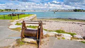
Callington, Polperro, and St Ives are great places to visit near Smith's Carn if you like towns.
Don't miss Kit Hill Country Park's hills if visiting the area around Smith's Carn.
There are a several good villages in the Smith's Carn area like Cremyll, and Botallack.
Mount Edgcumbe House and Country Park is a great place to visit close to Smith's Carn if you like historic buildings.
Airports to visit near Smith's Carn include Cornwall Airport Newquay, and Land's End Airport.
Smith's Carn History
There are some historic monuments around Smith's Carn:
- Three platform cairns and adjacent prehistoric linear boundary on Wingletang Down, 70m west of Crooked Rock
- Two platform cairns on Wingletang Down, 35m WNW of Wingletang Carn
- Hut circle settlement in Pendrathen, St Mary's
- Platform cairn 65m ENE of the Clapper of Works, Gugh
- Round cairn on Wingletang Down, 105m SSW of Sun Rock
- Two round cairns 90m north of the Clapper of Works, Gugh
- Prehistoric field system, hut circle and middens on southern Annet
- Gig shed on the north coast of Great Porth, Bryher
- World War II pillbox west of Porth Hellick, 90m north of Drum Rock, St Mary's
- Eight platform cairns and incorporated prehistoric irregular field system south west of Carn of Cove Vean on Wingletang Down
- Early medieval cemetery 40m north of St Nicholas's Priory, Tresco
- Civil War battery and prehistoric entrance grave on the Carn of Works, Gugh
- Kerbed platform cairn on Salakee Down, 190m north west of the Giant's Castle cliff castle, St Mary's
- Civil War breastwork and battery 60m east of Carn Nore, St Mary's
- Kerbed platform cairn with cist 90m north west of Carn Kimbra, Gugh
- Platform cairn on Burnt Island
- Post-medieval smugglers' cache at 'Smugglers' Tresco
- Prehistoric settlement and field system at Porth Killier, St Agnes
- Prehistoric chambered cairn 60m north of Knackyboy Carn, St Martin's
- Kerbed platform cairn 90m north west of Stoney Porth, White Island
- Kerbed platform cairn on Wingletang Down, 80m north east of Porth Askin
- Platform cairn on Wingletang Down, 130m north west of Wingletang Carn
- Prehistoric field systems, settlement and cairns, with post-medieval boundary and shelter on Northwethel
- Post-medieval smugglers' cache at Tresco Abbey, Tresco
- Prehistoric cairn cemetery, field system and settlements on Top Rock Hill, St Martin's
- Entrance grave 23m west of Old Rock, Porth Hellick Down, St Mary's
- Late 19th-early 20th century defended barracks and caretaker block at Greystones, The Garrison, St Mary's
- Prehistoric linear boundary and cairns south west of The Bar, Bryher
- Platform cairn on northern Peninnis Head, 200m ESE of Buzza Tower
- Prehistoric to Romano-British field system and settlement at Higher Town, St Agnes
- Prehistoric field system, settlement and cairn east of Barnaby Lane, St Agnes
- Prehistoric cairn cemetery and field system on Tinkler's Hill, St Martin's
- World War II pillbox and Civil War battery at Tolman Point, St Mary's
- Civil War battery at Works Point, Bryher
- Late 19th-early 20th century Steval Battery on The Garrison, St Mary's
- Prehistoric linear boundary south east of Horse Rock on Porth Hellick Down, St Mary's
- Prehistoric entrance grave and two round cairns on the Clapper of Works, Gugh
- Prehistoric settlement and field system on Little Ganilly
- Post-medieval watch house and Coastguard lookout on Watch Hill, Bryher
- Two round cairns 85m east of Dutchman's Carn, Peninnis Head, St Mary's
- The Cat's Coffin World War II pillbox, Old Town, St Mary's
- Three platform cairns on Wingletang Down, 135m south of Crooked Rock
- The Old Man prehistoric standing stone, Gugh
- Civil War battery at Kettle and Pans rocks, Peninnis Head, St Mary's
- Kerbed platform cairn 360m north of the Pest House, St Helen's
- Prehistoric field system and settlement in southern Appletree Bay, Tresco
- Civil War battery 150m WNW of Church Point, St Mary's
- Entrance grave 80m SSE of Basin Rock, Porth Hellick Down, St Mary's
- Nineteenth century gig-shed north east of Porth Askin
- Prehistoric hut circle and Civil War fieldworks on eastern Toll's Hill, St Mary's
- Prehistoric field system and post-medieval quay in Great Porth, Bryher
- Prehistoric field system and stone setting, Civil War fieldworks, post medieval kelp pits and quay on Toll's Island, St Mary's
- Prehistoric field system and Civil War fieldworks on south western Carn Morval Down, St Mary's
- Prehistoric chambered cairns and boundaries on Middle Arthur, St Martin's
- Kerbed platform cairn 80m north east of Mount Todden Farm, St Mary's
- Two entrance graves 220m ENE of Salakee Farm, St Mary's
- Platform cairn on Carn Morval Down, 235m north of Isles of Scilly Golf Course club house, St Mary's
- Three prehistoric cairns on Gweal Hill, Bryher
- Prehistoric cairn group on Great Hill, Tean
- Prehistoric linear boundary SSE of The Island, Bryher
- Platform cairn on Wingletang Down, 90m north west of Wingletang Carn
- Prehistoric to post-medieval funerary, field system and settlement remains, with post-medieval kelp pit and deer park on and adjacent to Samson
- Round cairn 120m ESE of Carn Wrean, Gugh
- Civil War battery 80m SSE of Dutchman's Carn, Peninnis Head, St Mary's
- Prehistoric midden at West Porth, Annet
- Two entrance graves and a platform cairn 95m NNW of Pig Rock on north eastern Salakee Down, St Mary's
- Kerbed platform cairn on Salakee Down, 85m north west of Church Porth, St Mary's
- Civil War battery on The Green, Bryher
- Civil War battery and 18th century watch house on Mount Todden, St Mary's
- Prehistoric field system east of Peninnis Head lighthouse, St Mary's
- Prehistoric linear boundary, cairn and post-medieval building on Taylor's Island, St Mary's
- Civil War breastwork ESE of Dick's Carn, St Mary's
- Prehistoric field system and kerbed cairn, with post-medieval kelp pit and linear boundary on southern White Island
- Kerbed platform cairn 45m NNW of Stoney Porth, White Island
- Platform cairn on Wingletang Down, 90m ESE of Carn Adnis
- Round cairn 55m west of Stoney Porth, White Island
- Two 19th century gig-sheds ENE of Porth Askin
- Two kerbed platform cairns 240m north of the Pest House, St Helen's
- Two kerbed platform cairns on Salakee Down, 40m north west of Church Porth, St Mary's
- Kerbed platform cairn on Helvear Hill, 210m ENE of Helvear Farm, St Mary's
- Platform cairn on Cruther's Neck, St Martin's
- Kerbed platform cairn with central funerary chamber on Salakee Down, 10m west of Church Porth, St Mary's
- Kerbed platform cairn 120m south east of Black Carn, Bryher
- Prehistoric field system and hut circle north of Crab's Ledge, Tresco
- Platform cairn on Wingletang Down, 50m NNE of Carn Adnis
- Harry's Walls unfinished 16th century artillery castle and adjacent prehistoric standing stone at Mount Flagon, St Mary's
- The Old Quay, Old Town Bay, St Mary's
- Post-medieval smugglers' cache at Porth Mellon, 110m west of Harry's Walls Battery, St Mary's
- Round cairn 25m south west of Vane Hill summit, Tresco
- Kerbed platform cairn on Wingletang Down, 75m SSE of Crooked Rock
- Platform cairn 195m north east of Salakee Farm, St Mary's
- Iron Age cist on northern Samson Hill, 165m NNE of Western Carn, Bryher
- Prehistoric field system and settlement on Heathy Hill, Bryher
- Prehistoric linear boundary and Civil War fieldworks on north western Toll's Hill, St Mary's
- Civil War breastwork and battery on the north coast of Normandy Down, St Mary's
- Prehistoric settlement, Romano-British cist cemetery and Civil War battery in northern Toll's Porth, St Mary's
- Prehistoric field system and settlement north of Appletree Point, Tresco
- Prehistoric field system and post-medieval breastwork and maze on Castella Down, St Agnes
- Post-medieval animal-driven crushing mill 270m south west of Blockhouse Cottage, Tresco
- Kerbed platform cairn on Wingletang Down, 120m SSE of Sun Rock
- Two entrance graves and a platform cairn 90m ESE of Basin Rock, Porth Hellick Down, St Mary's
- Platform cairn on Wingletang Down, 25m south of Sun Rock
- Prehistoric field system on Gweal Hill, Bryher
- Platform cairn on Wingletang Down, 60m south of Porth Askin
- Three platform cairns on Wingletang Down, 110m ENE of Wingletang Carn
- Prehistoric cairn cemetery and field system on Shipman Head Down and Great Bottom, Bryher
- Platform cairn on Wingletang Down, 115m north west of Wingletang Carn
- Two kerbed platform cairns north of Bonfire Carn on eastern Samson Hill, Bryher
- Prehistoric house platform and boundary north east of Carn Leh, St Mary's
- Prehistoric field system and Romano-British cist in Green Bay, Bryher
- The Giant's Castle cliff castle, St Mary's
- Cromwell's Castle mid-17th century blockhouse and 18th century gun platform on the western coast of Castle Down, Tresco
- Round cairn 20m NNE of the Carn of Works, Gugh
- Civil War battery above Porth Hellick Point, St Mary's
- Kerbed platform cairn and prehistoric field system north west of Porth Morran, White Island
- Oliver's Battery, Tresco
- Prehistoric hut circle south of The Brow, Bryher
- Civil War battery and two associated platforms 300m south east of Bar Point, St Mary's
- Prehistoric platform cairn, settlement and field system at Pernagie, St Martin's
- Round cairn 50m WSW of Vane Hill summit, Tresco
- Kerbed platform cairn with funerary chamber 190m north east of Water Rocks, Normandy Down, St Mary's
- Platform cairn on Carn Morval Down, 275m NNW of Isles of Scilly Golf Course club house, St Mary's
- Post-medieval pilot lookout on Timmy's Hill, Bryher
- Prehistoric kerbed boulder 172m north west of Horse Point, St Agnes
- Hut circle settlement and Civil War breastwork north east of Porth Minick, St Mary's
- Kerbed platform cairn on Wingletang Down, 85m south west of Crooked Rock
- Round cairn 30m north west of the Carn of Works, Gugh
- Prehistoric field system and settlement in Bathinghouse Porth, Tresco
- Prehistoric enclosure south east of The Brow, Bryher
- The Star Castle, St Mary's
- King Charles' Castle mid-16th century artillery castle and Civil War earthen artillery defence on western Castle Down, Tresco
- Prehistoric entrance grave and regular field system on north western Porth Hellick Down, St Mary's
- Entrance grave on Salakee Down, 160m north west of Church Porth, St Mary's
- Platform cairn with inner kerb 70m north east of the Carn of Works, Gugh
- World War II pillbox 250m south east of Carn Gwavel Farm, St Mary's
- Entrance grave on the summit of the northern hill, White Island
- Early 20th century gun battery at Bant's Carn, St Mary's
- St Agnes lighthouse
- Entrance grave 135m NNE of Water Rocks, Normandy Down, St Mary's
- Medieval or later shipwreck grave 52m NNE of Crooked Rock, Wingletang Down
- Two round cairns 65m NNW of the Clapper of Works, Gugh
- Prehistoric cliff castle and cairns on Shipman Head, Bryher
- The Long Rock prehistoric standing stone on Long Rock Down, St Mary's
- Prehistoric field system in southern Pentle Bay, Tresco
- Prehistoric entrance grave, the middle one of three on Cruther's Hill, St Martin's
- Prehistoric cairn group on Abbey Hill, Tresco
- Ennor Castle, Old Town, St Mary's
- Kerbed platform cairn on Wingletang Down, 160m north east of Horse Point
- Civil War battery on northern slope of Mount Todden Down, St Mary's
- Two kerbed platform cairns 50m north of Porth Morran, White Island
- Kerbed platform cairn 110m north of Porth Morran, White Island
- Civil War battery at Tolman Carns, St Mary's
- Kerbed platform cairn on Salakee Down, 55m west of Church Porth, St Mary's
- Civil War breastwork and two prehistoric stone hut circles at Little Porth, St Mary's
- Prehistoric entrance grave and round cairn on western Samson Hill, Bryher
- Two early post-medieval quays in north and north western Periglis, St Agnes
- Iron Age to Romano-British fogou on northern Peninnis Head, 170m south of Carn Gwavel Farm, St Mary's
- Late 19th-early 20th century Woolpack Battery on The Garrison, St Mary's
- Round cairn 155m NNE of Water Rocks, Normandy Down, St Mary's
- Prehistoric linear boundary on Puffin Island
- Round cairn 135m north east of Dutchman's Carn, Peninnis Head, St Mary's
- Round cairn with peripheral kerb 50m north of Cuckold's Carn, Gugh
- Kerbed platform cairn on the north hill, Annet
- World War II pillbox between Thomas' Porth and Porthaloo, St Mary's
- Round cairn on Helvear Down, 300m NNE of Higher Trenoweth Farm, St Mary's
- Prehistoric house platform settlement south west of English Island Carn, St Martin's
- Platform cairn on Wingletang Down, 78m north of Crooked Rock
- Round cairn 90m north east of the Carn of Works, Gugh
- Civil War battery on Helvear Hill, St Mary's
- Civil War breastwork and battery on Newford Island, St Mary's
- Kerbed platform cairn 90m north west of Old Rock, Porth Hellick Down, St Mary's
- Round cairn 40m south west of Dropnose Point, Gugh
- Prehistoric entrance grave at Works Carn, Bryher
- Prehistoric to Romano-British ritual, funerary and settlement remains on Par Beach, St Martin's
- Civil War battery at Carn Leh, St Mary's
- Entrance graves, standing stones, field systems, settlements and post-medieval breastwork, kelp pit and stone pits on Halangy and Carn Morval Downs, St Mary's
- Prehistoric field system on eastern Peninnis Head, St Mary's
- Prehistoric linear boundary 50m ENE of Mount Todden Battery, St Mary's
- Kerbed platform cairn 15m north east of Inner Blue Carn, St Mary's
- Prehistoric cairns, entrance graves, field system and settlements and post-medieval kelp pits on Kittern Hill, Gugh
- Two platform cairns north east of Vane Hill summit, Tresco
- Prehistoric funerary, ritual and settlement remains; post-medieval defences, tin mine, lookouts and enclosures on Castle Down, Tresco
- Entrance grave 105m south east of Basin Rock, Porth Hellick, St Mary's
- Platform cairn on Wingletang Down, 30m south east of Porth Askin
- Kerbed platform cairn 175m NNW of Hoe Point, Gugh
- Round cairn 40m north east of the Carn of Works, Gugh
- Nineteenth century horse engine and threshing machine at Lower Town Farm, St Agnes
- Platform cairn on Wingletang Down, 65m SSW of Porth Askin
- Kerbed platform cairn and prehistoric house platform 370m NNW of the Pest House, St Helen's
- Post-medieval breastwork, curtain wall and associated defensive structures on the periphery of The Garrison, St Mary's
- Two entrance graves, a prehistoric field system, and Civil War fieldworks and blockhouse on Innisidgen Hill and Helvear Down, St Mary's
- Prehistoric round cairn 255m south west of Blockhouse Cottages, Tresco
- Entrance grave 47m north west of Old Rock, Porth Hellick Down, St Mary's
- Kerbed platform cairn on Wingletang Down, 45m south of Beady Pool
- Kerbed platform cairn on Wingletang Down, 75m NNE of Porth Askin
- Prehistoric boundary wall east of Carn Irish, Annet
- Prehistoric cairns, prehistoric to post-medieval settlements and field systems, an early Christian focus, post-medieval kelp pits and quay on Tean and Old Man
- St Warna's Well, St Agnes
- Prehistoric regular field system north east of St Warna's Carn
- Kerbed platform cairn on Wingletang Down, 160m north west of Horse Point
- Round cairn on Wingletang Down, 50m south west of Porth Askin
- Kerbed platform cairn on Wingletang Down, 25m SSW of Beady Pool
- Prehistoric field system on the south west flank of Samson Hill, Bryher
- Mid-16th century blockhouse and ramparts with adjacent walling and occupation deposits at Block House Point
- Kerbed platform cairn 160m north of Hoe Point, Gugh
- Round cairn 137m east of Helvear Farm, St Mary's
- Prehistoric linear boundaries, house platform and cairn on south western Peninnis Head, St Mary's
- Prehistoric entrance grave, the southern one of three, and kerbed round cairn with cist on Cruther's Hill, St Martin's
- Prehistoric entrance grave, the northern one of three on Cruther's Hill, St Martin's
- St Nicholas' Priory, Tresco
- Prehistoric field system and cairn, early and later medieval religious complex, post-medieval lookout and quarantine station on St Helen's
- Lighthouse-builders' operational base on Rosevear
- Post-medieval kelp pit on the western coast of Tinkler's Hill, St Martin's
- Round cairn on Wingletang Down, 120m SSW of Sun Rock
- Kerbed round cairn with central cist on Gun Hill, St Martin's
- Prehistoric to early medieval field system and settlement at Dial Rocks, Tresco
- The Rocket House 17th-18th century powder magazine and adjacent prison on The Garrison, St Mary's
- Two kerbed platform cairns on Wingletang Down, 110m north east of Wingletang Carn
- Platform cairn on Turfy Hill, St Martin's
- Round cairn with funerary chamber on Buzza Hill, 45m west of the Buzza Tower, St Mary's
- Round cairn 130m north east of Peninnis Head lighthouse, St Mary's
- Civil War battery and associated platform at Carn Morval Point, St Mary's
- Prehistoric cairn and prehistoric to post-medieval field systems between The Plains and Wine Cove, St Martin's
- Two kerbed platform cairns 40m north of Porth Morran, White Island
- Prehistoric linear boundary on Dropnose Point, Gugh
- Round cairn 108m NNE of Peninnis Head lighthouse, St Mary's
- Platform cairn on Wingletang Down, 100m NNE of Carn Adnis
- Four round cairns 70m south east of Carn Wrean, Gugh
- Platform cairn 100m NNW of Water Rocks, Normandy Down, St Mary's
- Prehistoric field system on the northern slope of Mount Todden, St Mary's
Places to see near Smith's Carn


Lakes near Smith's Carn
Rivers near Smith's Carn
- West Looe River
- Polperro River
- East Looe River
- Seaton
- Upper River Ruthern
- Amble
- Camel (De Lank to Stannon)
- Stannon Stream
- Lower River Camel
- St Lawrence Stream
- Issey Brook (Camel)
- Upper River Amble
- De Lank River
- Lower River Ruthern
- Demelza Stream (Ruthern)
- Polmorla Stream
- Upper River Camel
- Amble tributary (Camel)
- Allen
- Lanivet Stream
- Porth Stream
- Gannel (Upper)
- Menalhyl
- Gannel (Lower)
- Harlyn Water
- Benny Stream
- Porthcothan Stream
- Trebant Water
- Lerryn River
- Cardinham Water
- Warleggan River
- Fowey (Upper)
- Fowey (Warleggan to St Neot)
- Pont Pill
- St Neot River
- Lower River Fowey
- Crackington Stream
- Marsland Water
- Lower River Strat
- Lower River Neet
- Upper River Neet
- Jacob Stream
- Valency
- Upper River Strat
- Coombe Valley Stream
- Newlyn River
- Trevaylor Stream
- Penberth Stream
- Marazion River
- Lamorna Stream
- Roseworthy Stream
- Portreath Stream
- Red River (Upper)
- Bolingey Stream
- Red River (Lower)
- Hayle
- Angarrack Stream
- Holywell Stream
- Kestle Stream
- Upper River Allen (Fal)
- Kenwyn
- Kennal
- Zelah Brook
- Brighton Stream
- Hicks Mill Stream
- Gwindra Stream
- Tresillian River (Lower)
- Upper River Fal
- Calenick Stream
- Trevella Stream
- Tresillian River (Upper)
- Lower River Allen (Fal)
- Lower River Fal
- Upper Carnon River
- Lower River Carnon
- Bokiddick Stream
- Crinnis River
- St Austell River
- Caerhays Stream
- Par River (Upper)
- Par River (Lower)
- Tywardreath Stream
- Carminowe Creek
- Gunwalloe Stream
- Cury River
- Helford River
- Manaccan River
- Poltesco River
- Lestraines River
- Lower River Cober
- Porthleven Stream
- Upper River Cober
- Gweek River
- Upper River Inny
- Penpont Water
- Cotehele Stream
- Lowley Brook
- Lower River Inny
- Lower River Tamar
- Upper River Lynher
- Tiddy
- Withey Brook
- Lower River Lynher
- Tala Water
- Canworthy Water
- Carey
- Tamar (River Ottery to River Deer)
- Tamar (Small Brook to River Deer)
- Upper River Ottery
- Kensey
- Tamar (Small Brook to Lamberal Water)
- Small Brook (Tamar)
- Claw
- Tamar (River Ottery to River Lyd)
- Lower River Ottery
- Upper River Tamar
- Caudworthy Water
- Deer
- Lamberal Water
- Bolesbridge Water
- Derril Water
- Middle River Ottery


