Padanaram
Padanaram is a Village in the county of Angus.
Padanaram postcode: DD8 1PT
There are great places to visit near Padanaram including some great towns, ruins, lakes, nature reserves, woodlands and historic monuments.
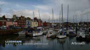
Padanaram has some unmissable towns nearby like Arbroath, Kirriemuir, Forfar, Montrose, Monifieth, Carnoustie, and Brechin.
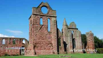
Arbroath Abbey is one of Padanaram's best, nearby ruins to visit in Padanaram.
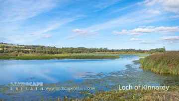
Don't miss Loch of Kinnordy's lakes if visiting the area around Padanaram.
Padanaram is near some unmissable nature reserves like Loch of Kinnordy,
Loch of Kinnordy is one of Padanaram's best, nearby woodlands to visit in Padanaram.
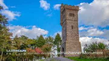
Historic Monuments to visit near Padanaram include Balmashanner Monument.
Padanaram History
There are some historic monuments around Padanaram:
- Wellford,enclosure 350m W of Prehistoric domestic and defensive: enclosure (domestic or defensive) SM6390
- Hare Cairn, cairn, Bractullo Muir Prehistoric ritual and funerary: cairn (type uncertain) SM6633
- Caddam, standing stone 700m ESE of Prehistoric ritual and funerary: standing stone SM150
- Restenneth Priory Ecclesiastical: priory SM90246
- Longbank,enclosure 400m NNW of Prehistoric domestic and defensive: enclosure (domestic or defensive) SM6347
- Nether Migvie,ring ditch E of Prehistoric domestic and defensive: house SM6470
- Carse Grey,settlement and souterrains 600m SW of Prehistoric domestic and defensive: settlement SM6311
- Baldoukie,souterrains 250m NE of Prehistoric domestic and defensive: souterrain, earth-house SM6315
- Law of Baldoukie,barrow 140m E of Baldoukie Farm Prehistoric ritual and funerary: barrow SM6314
- East Mains of Whitewell,souterrains 400m NNW of Prehistoric domestic and defensive: souterrain, earth-house SM6371
- Barnyards,enclosure 100m NW of Prehistoric domestic and defensive: enclosure (domestic or defensive) SM6355
- Caddam,souterrain 350m ENE of Prehistoric domestic and defensive: souterrain, earth-house SM6345
- Prosen Bridge,souterrain 500m NNW of Prehistoric domestic and defensive: souterrain, earth-house SM6305
- West Kinwhirrie, souterrains 250m NE of Prehistoric domestic and defensive: souterrain, earth-house SM6765
- Glamis 1, cross slab 140m WSW of Loanhead Crosses and carved stones: cross slab SM151
- Meathie church and graveyard, 330m S of Mains of Easter Meathie Ecclesiastical: church SM10090
- Carlunie Hill, hut platforms 300m E of summit Prehistoric domestic and defensive: platform SM6450
- Meikle Coull,souterrains 250m WSW of Prehistoric domestic and defensive: souterrain, earth-house SM6331
- Nether Arniefoul, unenclosed settlement 500m NE of Prehistoric domestic and defensive: settlement SM6423
- Newton of Glamis, enclosure 400m SSE of Prehistoric domestic and defensive: enclosure (domestic or defensive) SM6422
- Inverquharity, Roman fort, Roman camp and Iron Age settlement 440m NE of 20th Century Military and Related: Fort; Prehistoric domestic and defensive: souterrain, earth-house; Roman: camp SM6452
- Hill of Redhall,enclosure 500m E of summit Prehistoric domestic and defensive: enclosure (domestic or defensive) SM6306
- Hatton Cairn, cairn, Bractullo Muir Prehistoric ritual and funerary: cairn (type uncertain) SM6630
- Kirkton,homestead moat 350m W of Secular: homestead moat SM6070
- Westfield,enclosures NW of Prehistoric ritual and funerary: enclosure (ritual or funerary) SM6053
- Carse Grey, stone setting 225m WNW of Prehistoric ritual and funerary: stone setting SM4461
- Fletcherfield,two standing stones Prehistoric ritual and funerary: standing stone SM119
- Bractullo Muir, cairn 600m NW of Hare Cairn 20th Century Military and Related: Pillbox; Prehistoric ritual and funerary: cairn (type uncertain) SM6632
- Bractullo Muir, cairn 190m ESE of Hatton Cairn Prehistoric ritual and funerary: cairn (type uncertain) SM6631
- Milton of Ogil ring ditch 250m WSW of Prehistoric domestic and defensive: house SM6356
- Gallowhill, cairns 525m and 555m NE of Wellbank Prehistoric ritual and funerary: cairn (type uncertain) SM121
- Meikle Coull,burial mound 1200m NW of Prehistoric ritual and funerary: barrow SM4734
- Glamis 2, cross slab 15m S of 10 Kirkwynd Crosses and carved stones: cross slab SM152
- Myreside,henge,enclosure and barrows NW of Prehistoric domestic and defensive: enclosure (domestic or defensive); Prehistoric ritual and funerary: henge SM5934
- Glamis Castle, enclosure 600m ENE of Prehistoric domestic and defensive: enclosure (domestic or defensive) SM6420
- East Memus, standing stone 700m NE of Prehistoric ritual and funerary: standing stone SM118
- Newton of Glamis, unenclosed settlement 100m W of Prehistoric domestic and defensive: settlement SM6421
- St Orland's Stone, Glamis Crosses and carved stones: cross slab SM90270
- Turfachie, ring ditches S of Prehistoric domestic and defensive: house SM6528
- Meikle Coull, souterrain 100m SW of Prehistoric domestic and defensive: souterrain, earth-house SM6332
- Muirskeith, standing stone 350m SE of Prehistoric ritual and funerary: standing stone SM122
- Meams, cairns 540m W of & 480m WNW of Balnagarrow Prehistoric ritual and funerary: cairn (type uncertain) SM4472
- Prosen Bridge,settlement and souterrain 600m NW of Prehistoric domestic and defensive: settlement SM6304
- Redwell,enclosure 700m NE of Prehistoric domestic and defensive: enclosure (domestic or defensive) SM6354
- Ballinshoe Castle, 370m ENE of Ballinshoe Secular: castle SM162
- Battledykes, Roman camp Prehistoric domestic and defensive: souterrain, earth-house; Roman: camp SM2308
- Fletcherfield,enclosure 100m SE of Prehistoric domestic and defensive: enclosure (domestic or defensive) SM5911
- Shielhill,pit alignments N of Shielhill Farm Prehistoric domestic and defensive: pit alignment; Prehistoric ritual and funerary: pit alignment (ritual or funerary) SM6348
- Westfield,enclosure SW of Prehistoric ritual and funerary: enclosure (ritual or funerary) SM6054
- Northmuir,enclosure 350m N of Hill of Kirriemuir Prehistoric domestic and defensive: enclosure (domestic or defensive) SM6346
- Arniefoul, cairn 820m NE of Prehistoric ritual and funerary: cairn (type uncertain) SM389
- Blackgate Smithy,stone circle Prehistoric ritual and funerary: stone circle or ring SM149
- Wester Logie,enclosures 250m SSW of Prehistoric domestic and defensive: enclosure (domestic or defensive) SM6313
- Denside Cottage, standing stone 150m E of Prehistoric ritual and funerary: standing stone SM115
- Caldhame Wood,Roman road Roman: road SM143
- Battledykes, cairn 475m SSE of Prehistoric ritual and funerary: cairn (type uncertain) SM7234
- East Mains of Whitewell,barrow and pits 200m NNW of Prehistoric ritual and funerary: barrow SM6372
- Hill of Kirriemuir, standing stone Prehistoric ritual and funerary: standing stone SM125
- Mains of Brigton,enclosure 500m N of Prehistoric domestic and defensive: enclosure (domestic or defensive) SM6047
- Queen Margaret's Inch, chapel and crannog Ecclesiastical: chapel; Prehistoric domestic and defensive: crannog SM7648
- Kirkbuddo Wood,Roman camp Roman: camp SM144
- Carlunie Hill, cairn Prehistoric ritual and funerary: cairn (type uncertain) SM6449
- Shielhill,pit alignments 200m NE of Shielhill Farm Prehistoric domestic and defensive: pit alignment; Prehistoric ritual and funerary: pit alignment (ritual or funerary) SM6349
- Drumshade, enclosure 400m E of Prehistoric domestic and defensive: enclosure (domestic or defensive) SM6418