Auchterhouse
Auchterhouse is a Village in the county of Angus.
Auchterhouse postcode: DD3 0TS
There are great places to visit near Auchterhouse including some great towns, ruins, lakes, nature reserves, woodlands and historic monuments.
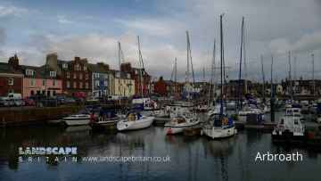
The area around Auchterhouse features a number of interesting towns including Arbroath, Kirriemuir, Forfar, Montrose, Monifieth, Carnoustie, and Brechin.
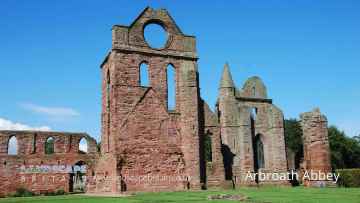
The area close to Auchterhouse boasts some of the best ruins including Arbroath Abbey.
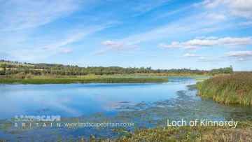
There are a number of lakes near to Auchterhouse including Loch of Kinnordy.
There are a number of nature reserves near to Auchterhouse including Loch of Kinnordy.
Auchterhouse is near some unmissable woodlands like Loch of Kinnordy,
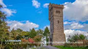
Balmashanner Monument is a great place to visit close to Auchterhouse if you like historic monuments.
Auchterhouse History
There are some historic monuments around Auchterhouse:
- Haughend, enclosure 500m W of Prehistoric domestic and defensive: enclosure (domestic or defensive) SM7263
- Belmont Castle, standing stone 240m S of Prehistoric ritual and funerary: standing stone SM7296
- Cursus and barrows, 240m NE of Bullionfield Prehistoric ritual and funerary: cursus/bank barrow SM6560
- Unenclosed settlement 260m ESE of Gray Cottage Prehistoric domestic and defensive: souterrain, earth-house SM6509
- Glamis 1, cross slab 140m WSW of Loanhead Crosses and carved stones: cross slab SM151
- High Keillor, symbol stone and cairn, 280m NW of Crosses and carved stones: symbol stone; Prehistoric ritual and funerary: cairn (type uncertain) SM146
- South Auchray, fort 300m NE of Prehistoric domestic and defensive: fort (includes hill and promontory fort) SM6561
- Barrow, 350m NNW of 28 Red Cliffs Prehistoric ritual and funerary: barrow SM6518
- Nevay Church, church and burial ground, Kirkinch Ecclesiastical: burial ground, cemetery, graveyard SM3002
- Mylnefield, ring ditch and souterrain 595m ESE of Prehistoric domestic and defensive: hut circle, roundhouse SM6469
- Newton of Glamis, enclosure 400m SSE of Prehistoric domestic and defensive: enclosure (domestic or defensive) SM6422
- Unenclosed settlement, 315m E of Dovecot Cottage Prehistoric domestic and defensive: hut circle, roundhouse SM6508
- Dronley Mill,enclosure 600m NE of Prehistoric domestic and defensive: enclosure (domestic or defensive) SM6466
- Dron Chapel Ecclesiastical: cathedral SM5592
- Wester Denoon,burial mound 950m W of Prehistoric ritual and funerary: cairn (type uncertain) SM4764
- Meigle,rectangular enclosures & posthole setting 120m SE of Chapelton Prehistoric domestic and defensive: enclosure (domestic or defensive) SM3708
- Dron Hill,fort Prehistoric domestic and defensive: fort (includes hill and promontory fort) SM3102
- Newton of Glamis, unenclosed settlement 100m W of Prehistoric domestic and defensive: settlement SM6421
- Cookston Farm, enclosure 100m W of Prehistoric domestic and defensive: enclosure (domestic or defensive) SM6281
- Bridgend of Ruthven,souterrain SW of Prehistoric domestic and defensive: souterrain, earth-house SM6334
- Mains of Inchture, prehistoric and later settlement and enclosures Prehistoric domestic and defensive: settlement; Secular: settlement, including deserted, depopulated and townships SM7205
- Falcon Stone, barrow 320m SSW of Prehistoric ritual and funerary: barrow SM6505
- Pictish symbol-bearing cross-slab, Kinnaird Mausoleum (formerly Rossie Church) Crosses and carved stones: symbol stone SM1658
- Balkello,standing stone Prehistoric ritual and funerary: standing stone SM6145
- Balkeerie,unenclosed settlement 900m SSW of Newmill Prehistoric domestic and defensive: settlement SM6302
- Cardean, Roman fort 230m NW of Cardean Mill Roman: fort SM2306
- Balkemback Cottages, stone circle 500m WNW of Prehistoric ritual and funerary: stone circle or ring SM2868
- East Pilmore,timber building 150m ESE of Prehistoric ritual and funerary: henge SM6464
- Auchtertyre,barrow 300m NNW of Prehistoric ritual and funerary: barrow SM6300
- West Mains, cairn 700m NNE of Prehistoric ritual and funerary: cairn (type uncertain) SM6591
- Carlunie Hill, cairn Prehistoric ritual and funerary: cairn (type uncertain) SM6449
- Barrows, 180m SW of Falcon Stone Prehistoric ritual and funerary: barrow SM6504
- Macbeth's Stone, standing stone Prehistoric ritual and funerary: standing stone SM2408
- Glamis 2, cross slab 15m S of 10 Kirkwynd Crosses and carved stones: cross slab SM152
- Denoon Law, fort Prehistoric domestic and defensive: fort (includes hill and promontory fort) SM138
- Newmill,ring ditch 600m SW of Prehistoric domestic and defensive: house SM6353
- Cardean Roman Camp and pre-historic barrow, Wester Cardean Prehistoric ritual and funerary: barrow; Roman: camp SM4337
- Dundee Law,fort Prehistoric domestic and defensive: fort (includes hill and promontory fort) SM2878
- Mylnefield, souterrains 290m and 385m E of Prehistoric domestic and defensive: souterrain, earth-house SM6468
- Hallyards Cottages, moated settlement S of Secular: homestead moat SM7262
- Dundee and Newtyle Railway,embankment SW of Balbeuchly House Industrial: rail SM6123
- West Nevay,burial mound 1800m S of Prehistoric ritual and funerary: mound (ritual or funerary) SM4697
- East Adamston, souterrain and unenclosed settlement 670m NNE of Prehistoric domestic and defensive: settlement SM6465
- Falcon Stone, cup-marked stone & barrow 500m SSE of Millhill Prehistoric ritual and funerary: barrow SM6503
- Kinpurney Hill, fort Prehistoric domestic and defensive: fort (includes hill and promontory fort); Secular: tower SM3219
- Castleton, site of castle 90m SE of The Feathers Secular: motte SM3554
- Eassie Old Church and cross slab Crosses and carved stones: cross slab; Ecclesiastical: church SM90125
- Castleward,burial mound 800m NW of Wester Denoon Prehistoric ritual and funerary: cairn (type uncertain) SM4742
- Braideston,enclosures 350m SE of Prehistoric domestic and defensive: enclosure (domestic or defensive) SM6352
- Invergowrie, enclosure 150m SW of TA Centre Prehistoric domestic and defensive: enclosure (domestic or defensive) SM6517
- Martin's Stone, cross slab, Balkello Crosses and carved stones: cross slab SM159
- Castlehill, barrows 210m SE of Prehistoric ritual and funerary: barrow SM7307
- Moncur Castle Secular: castle SM5509
- Belliduff, cairn 380m NE of Belmont Castle Prehistoric ritual and funerary: cairn (type uncertain) SM7325
- Market Knowe,enclosure 340m SSE of North Bank Prehistoric domestic and defensive: enclosure (domestic or defensive) SM2879
- Huntly Farm, enclosures 300m ESE of Prehistoric domestic and defensive: enclosure (domestic or defensive) SM6559
- East Pilmore, unenclosed settlement 1000m E of Prehistoric domestic and defensive: settlement SM6519
- Selvie,ring ditch and pit enclosure 500m NE of Prehistoric domestic and defensive: house SM6350
- Castlehill, unenclosed settlement 100m E of Prehistoric domestic and defensive: settlement SM7252
- Prehistoric enclosure and roundhouses, 150m WNW of West Pilmore Farm Cottages Prehistoric domestic and defensive: enclosure (domestic or defensive) SM6524
- Invergowrie, souterrains W of TA Centre Prehistoric domestic and defensive: souterrain, earth-house SM6516
- Wallace Tower Secular: tower SM5436
- Dronley House, mound 150m S of Prehistoric ritual and funerary: mound (ritual or funerary) SM6535
- Unenclosed settlement and enclosure, 185m north of Eastbank Farm Prehistoric domestic and defensive: enclosure (domestic or defensive) SM6534
- Hurly Hawkin, enclosure, broch and souterrain 80m S of Prehistoric domestic and defensive: broch SM140
- Souterrains, 162m W of Westwood Prehistoric domestic and defensive: souterrain, earth-house SM6467
- Kinpurnie Castle,cairn 400m WNW of Prehistoric ritual and funerary: cairn (type uncertain) SM6299
- Enclosures, barrows and pits 360m N of 8 Glebe Park Prehistoric domestic and defensive: enclosure (domestic or defensive); Prehistoric ritual and funerary: enclosure (ritual or funerary) SM7203
- Paddock Stone,standing stone 90m NE of Greystone House Prehistoric ritual and funerary: standing stone SM2999
- Dundee and Newtyle Railway,embankment N of Baldragon Industrial: rail SM5967
- Glamis Castle, enclosure 600m ENE of Prehistoric domestic and defensive: enclosure (domestic or defensive) SM6420
- Gourdie, stone circle 850m S of Prehistoric ritual and funerary: stone circle or ring SM128
- Carlunie Hill, hut platforms 300m E of summit Prehistoric domestic and defensive: platform SM6450
- Unenclosed settlement 300m SW of Westwood SM6628
- Moncur, remains of timber buildings 400m WSW of Prehistoric domestic and defensive: hall SM7202
- St Peter's Church & graveyard, Invergowrie Ecclesiastical: burial ground, cemetery, graveyard SM2996