Wookey Hole Caves by RJL
Wookey Hole Caves
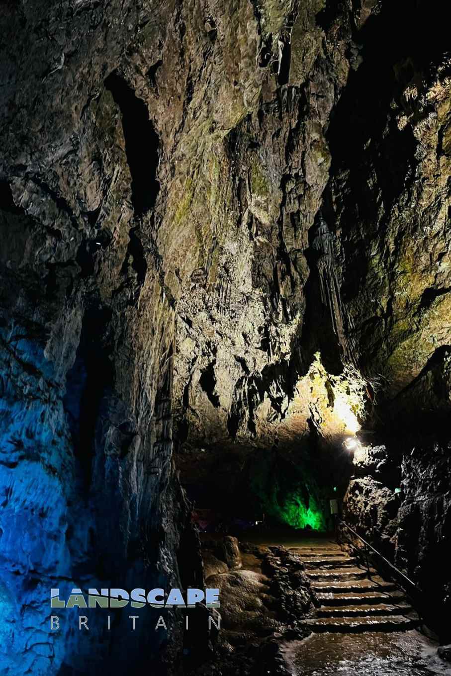
Wookey Hole Caves, located close to the village of Wookey Hole in Somerset. This intricate system of limestone caverns has been carved out over millions of years by the relentless action of the River Axe. Beyond its geological significance, the caves have a rich tapestry of history and folklore intertwined with their haunting chambers and dark passageways.
Stepping into the Wookey Hole Caves is like taking a journey back in time. Ancient human remains and artifacts discovered within indicate that they have been used as a shelter by humans for over 45,000 years. The Paleolithic inhabitants, Roman settlers, and others throughout history have left traces of their existence within these caverns.
However, it’s not just the archeological finds that captivate visitors. The legends and myths associated with the caves add an aura of mystery. The most famous of these tales is that of the Wookey Hole Witch, a figure said to have been turned to stone by a monk, and her petrified form can still be spotted inside the cave today.
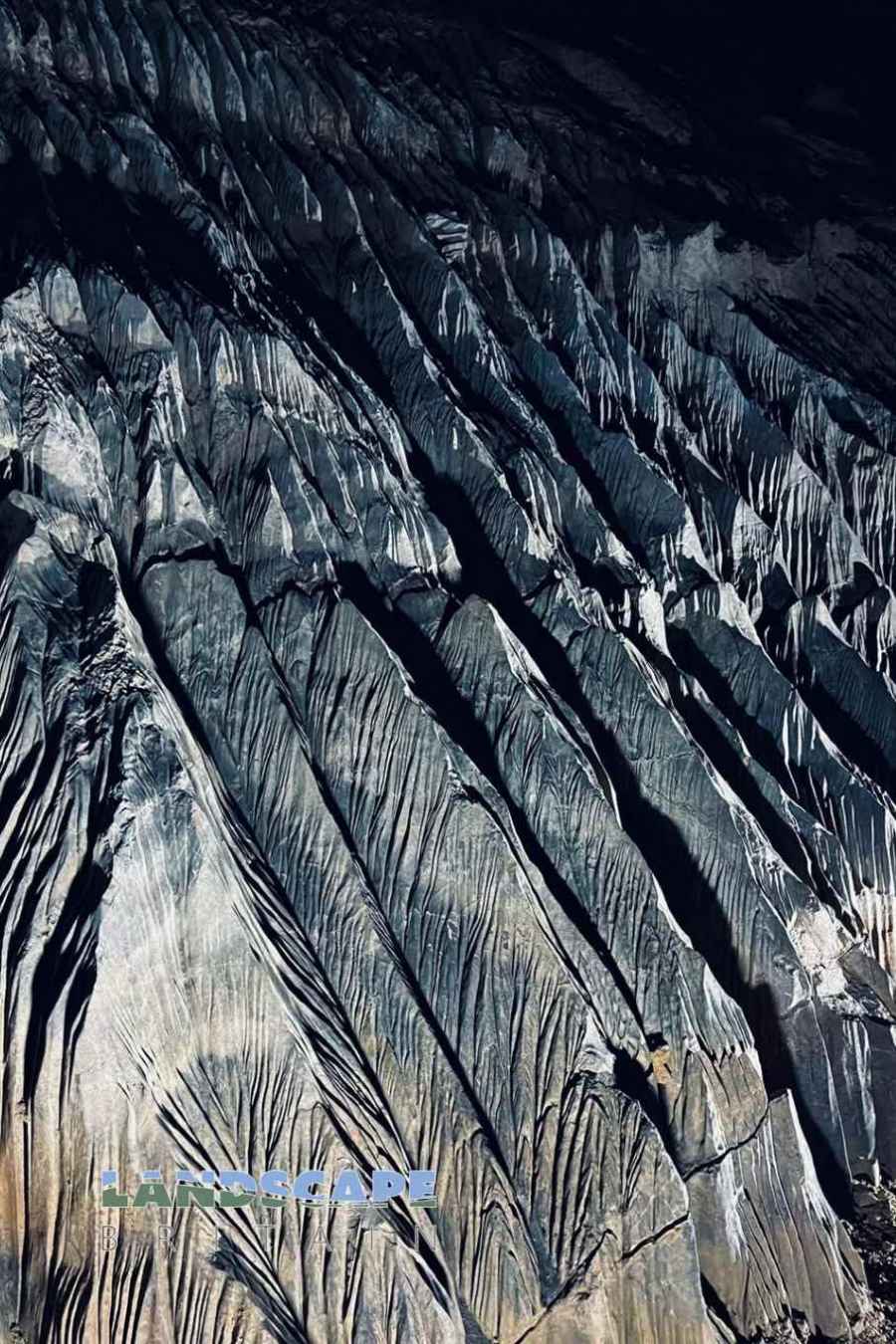
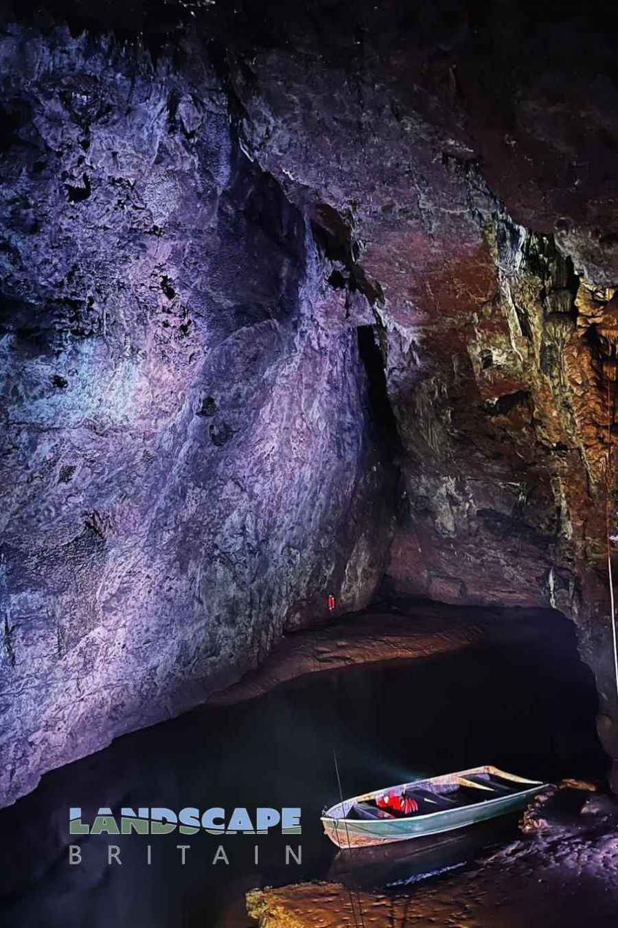
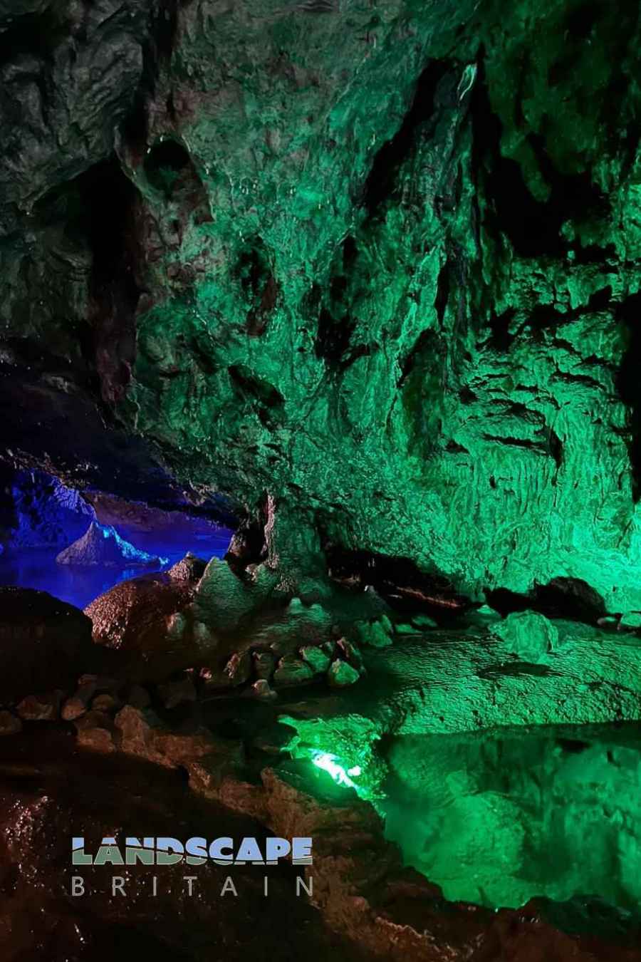
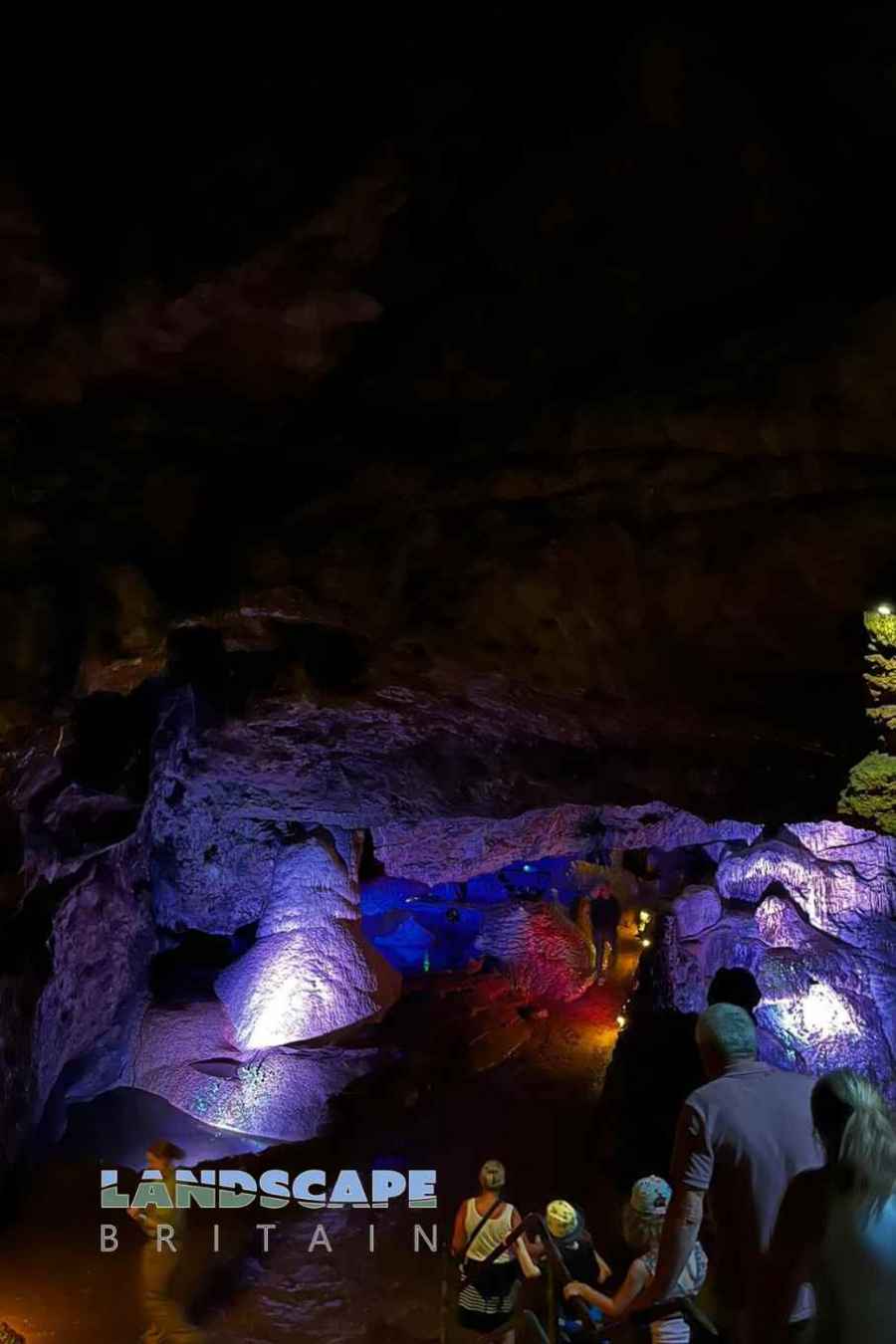
Stalactites and stalagmites, which have been formed by millennia of mineral deposits, create awe-inspiring formations within the caves. The Cathedral Chamber and the Witch’s Parlour are among the many highlights that visitors encounter as they traverse the depths. Additionally, the cave system is home to one of Britain’s largest underground rivers, and the cold, clear waters of the River Axe can be witnessed flowing through the caves.
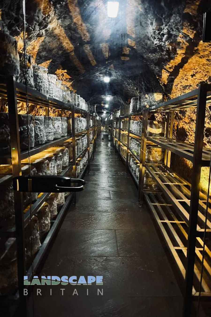
Over time, the Wookey Hole Caves have not just been a site of natural wonder, but also of enterprise. Historically, the caves housed a paper mill which utilized the constant flow of the River Axe. Today, while the mill still stands as a testament to the industrial past, the caves are primarily an attraction, drawing in visitors from all over the world who are eager to experience their magic and mystery firsthand.
Wookey Hole Caves is in Mendip Hills AONB, a designated Area of Outstanding Natural Beauty.
Created: 11 August 2023 Edited: 29 November 2023
Wookey Hole Caves Information
Wookey Hole Caves Address
The Mill, High St, Wells, Wookey Hole, Wells BA5 1BB, UK
BA5 1BB
Website: http://www.wookey.co.uk/
Get directionsLocal History around Wookey Hole Caves
There are some historic monuments around including:
Long barrow 600m east north east of Brimble Pit PoolAshen Hill barrow cemetery: a group of eight round barrows 500m southeast of Harptree LodgeBowl barrow 900m south west of Bristol Plain Farm: part of a group of round barrows south and south west of Bristol Plain FarmBowl barrow 340m north-east of Wellington FarmGlastonbury lake villageFenny Castle Cross: a medieval wayside cross 20m north west of Castle Farm, CastleTwo bowl barrows 550m south west of Haydon HouseBowl barrow 400m southeast of Wellington FarmBowl barrow 600m east of Priddy Hill FarmBowl barrow 390m northeast of Bristol Plain FarmBowl barrow 450m north west of Harptree LodgeBowl barrow 430m north east of Stoke WoodsKing's Castle enclosures, Iron Age defended settlementBowl barrow 350m north west of Harptree LodgeBowl barrow 470m south east of Southfield FarmWestbury Beacon, a bell barrow 720m west of Brimble Pit PoolBowl barrow 260m east of Templedown FarmBowl barrow 430m northwest of King Down FarmBowl barrow 450m southwest of Fernhill FarmSavory's HoleSt Cuthbert's and Chewton lead mines and Fair Lady WellBowl barrow 570m south east of Southfield FarmBowl barrow 250m northeast of King Down FarmBowl barrow 310m southeast of Eastwater FarmThree bowl barrows in Big Plantation, 690m south west of BeechbarrowBishop's palaceOutlook CaveBowl barrow on Stock Hill: part of the Stock Hill round barrow cemeteryBowl barrow 70m west of Rowberrow FarmRound barrow cemetery 470m and 400m north of Pen Hill FarmBowl barrow 300m south west of Harptree LodgeRhinoceros Hole, WookeyBowl barrow 450m east of Bristol Plain FarmBowl barrow 850m south of Bristol Plain Farm: part of a linear round barrow cemeteryPair of bowl barrows 640m south of Bristol Plain Farm: part of a linear round barrow cemeteryBowl barrow 150m southwest of King Down FarmBowl barrow 90m northeast of Hill ViewHenge 370m north east of Drove CottageBowl barrow 550m south of Bristol Plain Farm: part of a linear round barrow cemeteryBowl barrow 380m south east of Southfield FarmCharterhouse lead worksBarrow, 350m east of Harptree LodgeFenny Castle: a motte and bailey castleBowl barrow 400m southwest of Moor ViewLong barrow, round barrow and cairn on Pen HillBowl barrow 520m south-east of Red Quar FarmBowl barrow 770m south of Townsend FarmBowl barrow 500m north of East WaterBowl barrow 300m west of Newlands FarmBowl barrow 180m west of Ubley Warren FarmBishop's Palace ruined portions, walls and well houseWestbury village crossBowl barrow 410m northeast of Bristol Plain FarmTwo round barrows SE of Castle of Comfort InnBowl barrow 170m south-east of Hunter's Lodge InnBowl barrow 430m southwest of King Down FarmBowl barrow 380m south east of BeechbarrowDeserted medieval farmstead and field system NW of Ebbor WoodBowl barrow 550m south east of Southfield FarmBowl barrow 570m south east of Lodmore FarmBowl barrow 490m north west of Pen Hill FarmPair of bowl barrows 405m east of East Water Drove (Part of Priddy Nine Barrows Cemetery)Linear barrow cemetery comprising six bowl barrows 510m south west of Townsend FarmBowl barrow 435m north west of Ivy CottageBowl barrow 320m east of Lodmore FarmBowl barrow 810m southeast of Bristol Plain FarmTwo bowl barrows 850m south east of Brimble Pit Pool: part of a group of round barrows north and east of Foxhills WoodBowl barrow 870m southwest of Dale FarmBowl barrow, 540m west of Brimble Pit PoolFive bowl barrows 500m north west of Cuckoo Cleeves: part of the Stock Hill round barrow cemeteryBowl barrow 750m southwest of Dale FarmBowl barrow 820m south of Bristol Plain Farm: part of a linear round barrow cemeteryPriddy Circle and barrow cemetery 400m north of Castle of Comfort InnBrowne's GateBowl barrow 420m north of Stoke WoodsBadger Hole, WookeyRowberrow: a bowl barrow 40m north of Hill ViewPriddy Glebe Barrow: a bowl barrow 25m north of St. Lawrence's ChurchBowl barrow 365m south west of Ubley Warren FarmBowl barrow in the garden of BeechbarrowStow Barrow : a bowl barrow 700m southwest of Haydon Grange FarmGroup of round barrows 750m north west of Ivy CottageLong barrow 370m south-south-east of Castle FarmBowl barrow 230m north west of Hunter's Lodge InnRound barrows in and near Wright's PieceRound barrows SW of Cleeve's PlantationBowl barrow 730m southeast of Bristol Plain FarmBowl barrow 330m north of Stoke WoodsBowl barrow 800m south of Townsend FarmBowl barrow 600m north of Rookham PlantationBowl barrow 130m west of St Lawrence's ChurchBowl barrow 650m northeast of Higher Pitts FarmBowl barrow 700m south of Bristol Plain Farm: part of a linear round barrow cemeteryBowl barrow 400m north of Stoke WoodsTwo bowl barrows 350m south of Brimble Pit Pool: part of a group of round barrows north and east of Foxhills WoodBowl barrow 340m east of Templedown FarmBowl barrow 870m southwest of Charterhouse Warren FarmBowl barrow 850m southeast of Bristol Plain FarmFour round barrows SE of Miners' Arms Inn, Chewton Rabbit WarrenBracelet CaveBowl barrow 460m east of Charterhouse Warren FarmBowl barrow, 455m west of Brimble Pit PoolBowl barrow 590m south-east of Charterhouse Warren FarmBowl barrow 510m south east of Lodmore FarmThree bowl barrows at Green Ore, two 150m south east and one 420m south west of Newlands FarmBowl barrow 350m northeast of Cheddar Head FarmBowl barrow 180m southwest of Yoxter FarmBowl barrow 550m south east of Brimble Pit Pool: one of a group of round barrows north and east of Foxhills WoodThree of the Priddy Circles and one barrow, 400m west of Castle FarmRound barrow 1435m SE of Miners' Arms InnBowl barrow 400m south of RookhamWestbury Camp, slight univallate hillfort, 750m north of Stokewood CottageBowl barrow 610m northwest of Whitestown FarmDeserted medieval hamlet E of DraycottBowl barrow 450m south-east of Red Quar FarmBowl barrow 760m southeast of Bristol Plain FarmBowl barrow 420m east of Bristol Plain FarmGroup of seven round barrows 380m east of East Water Drove (Part of Priddy Nine Barrows Cemetery)Bishop's tithe barnBowl barrow 70m northeast of King Down FarmThree bowl barrows 400m north west of Haydon HutRoman building 270m north east of Priddy churchBowl barrow 570m west of Newlands FarmBowl barrow 20m northwest of Whitestown FarmBowl barrow 850m south of Townsend FarmBowl barrow 70m northwest of Hill ViewBowl barrow 300m southwest of Moor ViewBowl barrow on Stock Hill: part of the Stock Hill round barrow cemeteryDisc barrow 610m northeast of Drove Cottage.


