
Wareham
Wareham
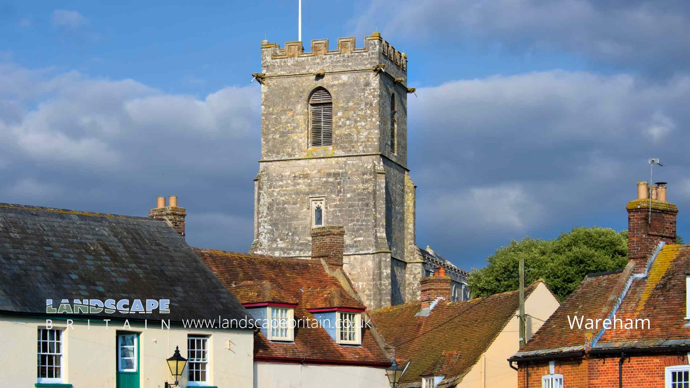
The historic market town of Wareham in Dorset is located on the River Frome and is well known for its Saxon walls which date back to the 9th century. The town has a number of interesting shops and cafes as well as a weekly market. Wareham is also home to several museums including the Dorset County Museum and the Purbeck Mineral and Mining Museum.
The town of Wareham is located in the county of Dorset in England. It is situated on the River Frome and is approximately 8 miles (13 km) from the coast. The town has a population of around 9,000 people.
The history of Wareham goes back to the Saxon period when it was founded by Alfred the Great in 876 AD. The town was originally called Weohham and was located on the site of an existing Roman settlement. The town grew in importance during the medieval period and was defended against attack by a set of walls which were built in the 9th century.
During the English Civil War, Wareham was occupied by Parliamentary forces. In 1644, a Royalist army attempted to retake the town but was defeated at the Battle of Lostwithiel.
The town continued to grow throughout the 18th and 19th centuries and became a centre for market gardening and agriculture. Today, Wareham is a popular tourist destination and is home to several museums including the Dorset County Museum and the Purbeck Mineral and Mining Museum.
If you are visiting England, then make sure you include a trip to the historic town of Wareham in your itinerary. You will not be disappointed!
Created: 20 October 2022 Edited: 29 November 2023
Wareham
Local History around Wareham
There are some historic monuments around including:
Romano-British villa 560m north east of East Creech FarmBowl barrow and cross dyke on Knowle Hill, 500m NNE of St Peter's ChurchSection of Battery Bank on Binnegar Plain, 830m north east of Stokeford FarmBowl barrow at the eastern end of Stonehill Down, 270m SSW of East Creech FarmLight Anti-aircraft battery on Holton Heath, 650m south east of Sandford HouseMedieval settlement at AfflingtonBowl barrow in Morden Park 350m south west of Hunting BridgeBowl barrow on Trigon Hill, 880m north east of Trigon HouseRound barrow cemetery on Povington Heath 550m north-east of Whiteway FarmBowl barrow on Arne Hill 270m south west of Arne Dairy HouseCross dyke on Knowle Hill, 430m south of East Creech FarmTwin barrow on Westholme Heath, 850m west of Hurst MillBowl barrow 1120m WNW of Peaked Close House: part of a dispersed round barrow cemetery on Corfe CommonBowl barrow 40m south east of The Drinking Barrow, forming part of the Grange Heath round barrow cemeteryBowl barrow on Stonehill Down, 250m south of East Creech FarmThe Drinking Barrow, forming part of the Grange Heath round barrow cemeteryBowl barrow 850m WNW of Peaked Close House: part of a dispersed round barrow cemetery on Corfe CommonCorfe Castle: a large enclosure castle, and 18th century Vineyard BridgeThe Harp StoneThorn Barrow: a bowl barrow on East Holme Range, 650m north-east of Whiteway FarmTwo bowl barrows on Great Ovens Hill, 650m and 570m NNW of Sandford BridgeBowl barrow on Creech Heath 720m ESE of Dodson's Farm, forming part of the Creech Heath round barrow cemeteryBell barrow on Grange Heath, 600m north of The Drinking Barrow, forming part of the Grange Heath round barrow cemeteryBowl barrow 900m WNW of Peaked Close House: part of a dispersed round barrow cemetery on Corfe CommonBowl barrow on Creech Barrow hillBowl barrow on Stoborough Heath 700m south of Icen HouseThree bowl barrows on Northport Heath, 940m and 985m north east of Alpha FarmGroup of six pillow mounds 470m north west of Barnston FarmFormer Royal Naval Cordite FactoryThree bowl barrows in Holme Lane Plantation, 200m south west of Squirrel's CottagesLinear earthwork on Wareham Common, 350m north west and 420m north east of Little FarmBowl barrow known as Povington Barrow, 300m west of Povington FarmBowl barrow on Farm Heath, 470m south east of Hill CottagesBell barrow and seven bowl barrows, forming a dispersed round barrow cemetery on Worgret Heath, 645m north west of Worgret Manor FarmGroup of three bowl barrows on Creech Heath 650m ESE of Dodson's Farm, forming part of the Creech Heath round barrow cemeteryFour bowl barrows 70m east of Seven Barrows Farm'Three Barrows': Group of three round barrows on the southern edge of Middlebere Heath, 240m NNE of Halfway InnBowl barrow 450m north-west of Rookery CottagesDecoy pond and associated overnight shelter on Decoy HeathThe King's Barrow 230m east of Bartlett's FirsBowl barrow on Stoborough Heath 80m north west of Hill ViewBowl barrow 650m WNW of Peaked Close House: part of a dispersed round barrow cemetery on Corfe CommonBowl barrow on Worgret Heath, 390m west of Little FarmGroup of four bowl barrows 250m WNW of Peaked Close House: part of a dispersed round barrow cemetery on Corfe CommonRound barrow cemetery on West Holme Heath, 850m north-west of Hurst MillBowl barrow 500m west of Worgret Manor Farm, forming an outlier of the Worgret Heath round barrow cemeteryBowl barrow in Pomfrey's PlantationBowl barrow on Worgret Heath, 320m north west of High TorThe northern of two bowl barrows on Holme MountBowl barrow 500m north east of The Drinking Barrow, forming part of the Grange Heath round barrow cemeteryBowl barrow on Stokeford Heath 720m WNW of Binnegar FarmBowl barrow on Farm Heath, 480m south east of Hill CottagesGroup of three bowl barrows on West Hill, 650m NNE of The Glebe HouseThree bowl barrows on Povington Heath, 400m south-west of Hurst MillBowl barrow on Farm Heath, 450m south west of Worgret Heath FarmBell barrow and two bowl barrows 170m north east of Holmebridge Post OfficeThree Lords' Barrow, 450m south east of Doreys FarmTwo bowl barrows on South Heath, 290m and 370m east of Binnegar HallLight Anti-aircraft battery on Holton Heath, 210m west of Sandford HouseBowl barrow on Knowle Hill, 660m north east of St Peter's ChurchBowl barrow on Knowle Hill, 630m north east of St Peter's ChurchSt Martin's ChurchBowl barrow 930m WNW of Peaked Close House: part of a dispersed round barrow cemetery on Corfe CommonBowl barrow on Northport Heath, 200m south east of Forest LodgePart of the defences of the Anglo-Saxon fortified centre of Wareham and part of the motte and bailey castle with shell keepBowl barrow 350m south-west of Rookery CottagesBowl barrow 500m north east of Afflington FarmBowl barrow on East Holme Range 690m north-east of Whiteway FarmRound barrow cemetery on Lulworth Heath known as `Five Barrows': 400m north-east of The CatHilltop enclosure and a pillow mound on Knowle HillBowl barrow 470m WNW of Peaked Close House: part of a dispersed round barrow cemetery on Corfe CommonGroup of linear earthworks on Worgret HeathBowl barrow on Morden Heath, 282m north-east of Decoy HouseThe Icen Barrow on Creech Heath, forming part of the Creech Heath round barrow cemeteryBowl barrow on Arne Hill 200m south of Arne Dairy HouseBowl barrow on Stoborough Heath 240m NNE of Hill ViewIron Age settlement and associated field system on Smedmore HillCross dyke on Knowle Hill, 470m SSE of East Creech FarmThe southern of two bowl barrows on Holme MountBell barrow on Stoborough Heath 380m NNE of Hill ViewBowl barrow on East Holme Range, 880m north west of Povington FarmBowl barrow in Bartlett's FirsWoolsbarrow, a hillfort on Bloxworth HeathOval barrow at the western end of Stonehill Down, 800m south west of East Creech FarmFour bowl barrows 150m north east of Seven Barrows FarmHillfort at Bulbury CampBowl barrow 200m south east of East OrchardSection of Battery Bank on South HeathThe Rings: a ringwork and bailey and a Civil War battery 400m south west of Corfe CastleHeavy Anti-aircraft battery on Arne HillBowl barrow 250m north-west of Rookery Cottages.Wildlife in and Around Wareham
Mammals found in Wareham
There have been 42 species of mammals recorded in the wareham area.
| American Mink (Neovison vison) |
| Bank Vole (Myodes glareolus) |
| Brown Hare (Lepus europaeus) |
| Brown Rat (Rattus norvegicus) |
| Common Dormouse (Muscardinus avellanarius) |
| Badger (Meles meles) |
| Bechstein's Bat (Myotis bechsteinii) |
| Brown Long-Eared Bat (Plecotus auritus) |
| Chinese Barking Deer (Muntiacus reevesi) |
| Common Seal (Phoca vitulina) |
Tap here for more mammals found in and around Wareham
Birds found in Wareham
There have been 242 species of birds recorded in the wareham area.
| (Anthus spinoletta/petrosus agg.) |
| Avocet (Recurvirostra avosetta) |
| Bar-Tailed Godwit (Limosa lapponica) |
| Barnacle Goose (Branta leucopsis) |
| Bearded Tit (Panurus biarmicus) |
| Arctic Tern (Sterna paradisaea) |
| Bar-Headed Goose (Anser indicus) |
| Barn Owl (Tyto alba) |
| Bean Goose (Anser fabalis) |
| Bittern (Botaurus stellaris) |


