Two Lads Cairn by munki-boy
Two Lads
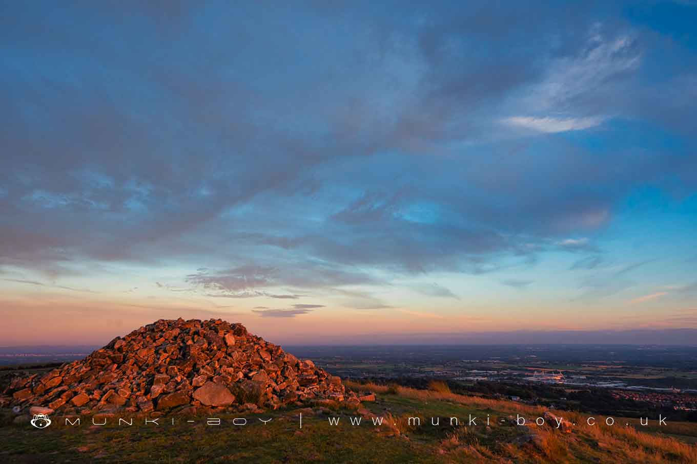
The Two Lads cairns on Crooked Edge Hill are a well-known landmark and possible ancient burial site. Often in the form of a circular tower, a form it has recently been restored to, or at other times collapsed or pulled down by the local council (for safety). Beloved by locals and mostly unnoticed by hordes of visitors to the Pike tower.
The history of the site is a total confusion with any real evidence obliterated long ago.
It seems probable that an ancient burial cairn existed here - there are plenty nearby and this seems like one of the better positions. The momunment we see today is large stone cairn on the site of an early OS triangulation pillar, thought to be on the site of an earlier monument marked by two stone cains or structures. Described by Rasbotham in the C18th as two ‘rude piles of stone’ around 6 and a half feet (2 metres) apart and built on a raised circular mound. Other mentions of the site such as Roby’s Specrtre Horseman (C19th) are quite probably based on Rasbotham’s account. Rasbotham does not mention the height of the cairns in 1776 but it is mentioned that the cairns were raised higher around 1787 ‘I imagine, by the proprietor of the common, with a view to their being more distinctly seen, perhaps at the place of his residence’(sic). Roby reports the height as about 12 feet in his book of 1843. Elsewhere the site is described as having a circular wall. However, Rasbotham does not mention a wall to my knowledge, he describes a roughly circular mound with an ‘entrance’ - a circular mound with a protruding area to the south.
The late 18th Century sketch in various sources and mentioned by Rasbotham shows a stylised view of the Pike with exaggerated tower and diminshed hill together with Crooked Edge Hill exaggerated to a similar shapes as the pike, but with two distinct, tower-shaped cairns on top - also of exaggerated size. This is in agreement with Rasbotham’s report with regard to the configuration of the cairns.
The early OS map shows the triangulation pillar beside a small, rectangular structure (other trig points do not), but no representation of stonework, despite smaller landscape features being represented. On subsequent maps there is shown a bit of structure, possibly representing rock, surrounding the triangulation pillar. On the 1950s map a circular structure is shown and strangely, on the 1960s map there are two structures similar to those described in Rasbotham’s account. However, in aerial photos from the 1940s, only one cairn is shown. As the earliest OS map shows no cairn, and the 1950s OS map shows two while photographic evidence shows only one, I am left to wonder how the OS came to have two structures surveryed to display on the later maps. The same ‘first edition’ series of maps shows the Noon Hill tumulus as an intriguing ‘Mound’ on the corresponding map sheet to the north. The modern OS maps have all erroneouly shown two cairns in my experience. In my opinion the OS at some point surveyed two cairns and they show this on some maps even today, the northmost cairn in the spot occupied by the single cairn today.
Despite having been rebuilt many times and perhaps temporarily being replaced by a triangulation pillar, I think the current cairn occupies the site of the northmost original cairn with a missing second cairn a short distance to the south-southeast. Two metres according to Rasbotham - but it would depend on the radius of the current cairn I suppose.
Leverhulme paid for an archaeological investigation around the late 1890s (?) and a 1950s local archaeologist (J. Winstanley?) accuses him of robbing out the second cairn entirely for building stone. I don’t know if this is true, the stone in the remaining cairn doesn’t look good for building to me. In any case, according to the OS map, a triangulation pillar occupied the site of the current cairn before 1850. I believe Leverhulme also investigated one of the two possibly quite old quarries on the west and southeast downslope areas.
The Spectre Horseman
Rasbotham names the monument as ‘The Wilder Lads’, which Roby goes on to equate with ‘Wild Leód’ which he says ‘is literally’ ‘The Wild People’ - which is a stretch because the ‘Wild’ part is not in O.E. but the ‘Leód’ part is, however that is usually a suffix. I think Roby goes on invoke the mysterious ‘wuduwāsa’ in connection with Willderswood which is fanciful to say the least. In short, with his legend ‘The Spectre Horseman’, he postulates a connection with the old tradition of The Wild Hunt and that the Two Lads is a Fairy Hill or Mound. I believe he does this singularly because he postulates the etymology of the name. I have never heard or seen any mention of this story locally other than those which quote Roby.
In his mid-20th Century book, Birtill posits the Spectre Horseman riding across the moor to the burial mound on Noon Hill, which gives the tale a feel of Watkins ley lines - but Noon Hill does not feature in Roby’s tale and the burial mound there was not ‘discovered’ until the 1950s. In fact you can ‘just’ see the Two Lads cairn from Noon Hill, just peeping up over the slope of Winter Hill - does that mean they’re at the same height? Yes, I just checked and they’re both around 385 metres - spooky.
The local area names Wilderswood and Wilders Moor are more likely to come from ‘wilddéor’ or ‘wildedeór’, wild deer or wild beast. It is said that in medieval times all this land was a private hunting forest which would have been stocked with wild beasts for hunting. However, in support of the Wilder Lads, there is a form in the Old Germanic which can mean abandonned or orphaned - left to the wild beasts so-to-speak. Which leads on nicely to…
The Wilder Lads
This story is quite common in folklore and there are several versions told in the local area. In story-chronological order (not necessarily the order in which they were first told/invented). The two sons of a Saxon king were lost on the moor - this one might be a tie-in with the local King Egbert’s palace legend. Two sons of Bishop Pilkington were lost - apparently he had two sons die at a young age. Two boys who worked in a mill in Darwen and had to cross the moor each day were lost - It’s true that people used to make long journeys to work on-foot in all weather, but Rasbotham’s report must pre-date this one. These tales all have parallels in other places and are not uncommonly told with local variations.
Did you know there’s another Two Lads, not that many miles away, with two cairns on a hilltop and a similar legend?
Created: 27 November 2016 Edited: 29 November 2023
Two Lads Cairn on Crooked Edge Hill
Two Lads
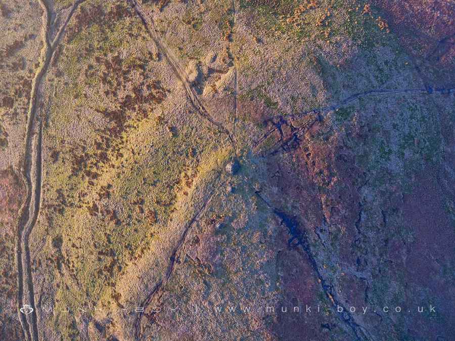
Two Lads LiDAR Map

Contains public sector information licensed under the Open Government Licence v3.0
Local History around Two Lads
There are some historic monuments around including:
Steam tramway reversing triangleRound cairn on Noon HillPike Stones chambered long cairnRound cairn 280m west of Old Harpers FarmRound cairn on Winter HillHeadless Cross, GrimefordRound Loaf bowl barrow on Anglezarke MoorGidlow Hall moated site, Aspull, 560m NNE of Pennington Hall.


