The Chevin
The Chevin
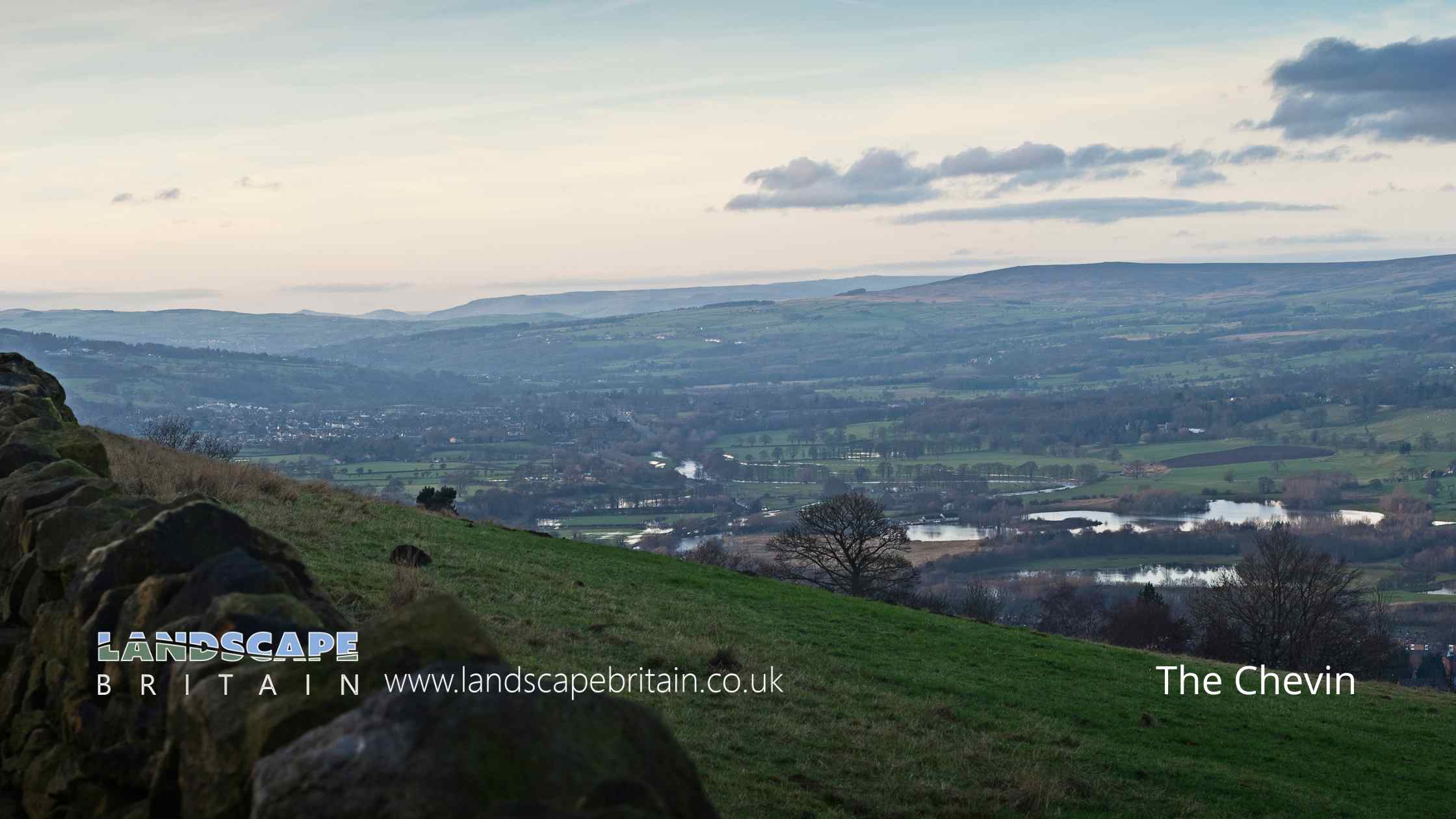
The Chevin, a distinctive ridge overlooking the market town of Otley in West Yorkshire, England, stands as an iconic feature of the landscape. Named after the Celtic word for “ridge”, The Chevin presents a striking silhouette against the sky, a feature that has shaped the identity of the area for centuries.
Geologically, The Chevin is part of the Carboniferous Millstone Grit, characteristic of the region. This rugged terrain, with its steep slopes and rocky outcrops, provides a stark contrast to the surrounding lower Wharfedale valley. Over the years, erosion and human activity have sculpted its current form, revealing a rich tapestry of history and natural beauty.
Historically, The Chevin has been a significant landmark. It is believed that the ridge was used for signal fires as early as the Iron Age, serving as a communication point across the valley. During the medieval period, the ridge provided a strategic vantage point, and there is evidence to suggest it played a role in local conflicts.
Today, The Chevin is a beloved local amenity, drawing visitors from near and far. It was declared a Country Park in 1989, recognising its importance as a recreational and conservation area. The park spans approximately 700 acres, offering a network of footpaths and bridleways that traverse through woodland, heathland, and open glades. This variety of habitats supports a diverse array of wildlife, including several species of birds, mammals, and insects.
One of the most popular features of The Chevin is the Surprise View. As its name suggests, this viewpoint offers breathtaking panoramic views of the Wharfedale valley and beyond. On a clear day, visitors can see as far as the Yorkshire Dales, making it a favourite spot for photographers and nature enthusiasts.
Culturally, The Chevin continues to play a vital role in the community. It serves as a backdrop for local events and festivals, and its presence is deeply intertwined with the identity of Otley and its inhabitants. The ridge has also inspired artists and writers over the years, featuring in paintings, photographs, and literary works.
In summary, The Chevin is not just a geographical feature; it is a symbol of natural beauty and historical significance. Its rugged landscape tells a story of geological formation, human history, and ecological diversity. As a country park, it provides a space for recreation, conservation, and education, making it a cherished part of the West Yorkshire countryside.
Created: 12 January 2024 Edited: 26 March 2024
The Chevin Details
The Chevin is a 282 metre high hill in West Yorkshire.
The Chevin
The Chevin LiDAR Map

Contains public sector information licensed under the Open Government Licence v3.0
Local History around The Chevin
There are some historic monuments around including:
Rock with at least two cup marks on Hollin Tree Hill, 840m NNE of Whin Hill Farm, Askwith MoorCup, ring and groove marked rock, 400m west of Carr FarmRock with at least 30 cup marks and some grooves near north east end of ridge, south of Snowden Beck in Ellers Wood, Dob Park, 400m north of Low ParkCup and groove marked rock east of New Close Quarry, 300m south west of Whitbeck ManorRock with cup marks, rings and grooves near derelict grouse butt, 440m SE of triangulation pillar on Shooting House Hill, Askwith MoorOtley BridgeCup and groove marked rock, 700m north east of Whin Hill Farm, Askwith MoorRoman period native settlement in Danefield Wood, 490m south west of Stubbings FarmCup, ring and groove marked rock 2m south of north wall of Gab Wood 330m E of Moseley Farm, CookridgeCup and groove marked rock in boulder walling between Southpiece Cottage and Bleach MillTwo carved rocks south of derelict grouse butt, 840m SSW of Crag HouseCarved rock below Snowden Crags on Snowden Carr, 100m south of Crag HouseRock with at least two cup marks south east of cairnfield on Snowden Carr, 720m SSE of Crag HouseCup marked rock 42m west of gate near Dob Park Bridge, adjacent to track on south bank of River WashburnCairnfield, enclosures, boulder walling, hollow way and carved rocks towards edge of Snowden Carr centred at 370m south east of Crag HouseRock with at least two cups and a groove east of the plantation on Weston Moor 450m north west of Weston Moor CottageRock with at least eight cups south of track on Weston Moor 480m WNW of Weston Moor CottageCairn 7m in diameter north of track east of plantation on Weston Moor 450m WNW of Weston Moor CottageCup, ring and groove marked rock near gate in enclosed pasture on Snowden Carr, 350m south of Low Hill FarmGritstone pillar with three cup marks in the north pavement of the A65 at Horsforth, 440m south east of the roundabout at Low FoldCup, ring and groove marked rock south of track on Weston Moor 500m WNW of Weston Moor CottageCup marked rock in Calverley Wood, 200m north east of junction of Calverley Cutting and Thornhill DriveRoman period native settlement in Poolscar Wood, 350m south of Stubbings FarmRock with at least seven cup marks at edge of track on Stoop Hill, 890m SSE of triangulation point on Shooting House Hill, Askwith MoorRock with cup marks enclosed by grooves at north east end of ridge, south of Snowden Beck in Ellers Wood, Dob Park, 420m north of Low ParkCup and ring marked rock 40m south east of Hillcourt, RawdonAnti-aircraft gunsite 280m east of Carlton HallCarved rock near north east corner of the plantation on Weston Moor 550m north west of Weston Moor CottageCup and ring marked rock at Hoyle Court Drive, CharlestownCup marked rock near gate in enclosed pasture on Snowden Carr, 460m south west of Washburn FarmRock with cup marks and grooves near boundary between Askwith Moor and Denton Moor, 600m east of DunkirkThree carved fragments of gritstone outcrop in enclosed pasture on Snowden Carr, 500m south west of Washburn FarmCup and ring marked rock known as the Knotties Stone on Otley Chevin, 270m north east of The Royalty public houseCup, ring and groove marked rock in enclosed pasture on Snowden Carr, 500m south east of Crag HouseRock with one or two cup marks near derelict walling below outcrop in enclosed pasture on Snowden Carr, 350m west of Carr FarmRock with one large cup mark, 230m east of the triangulation pillar on Shooting House Hill, 610m SSW of Crag HouseCup marked rock 640m north east of Whin Hill Farm, Askwith MoorCup and ring marked rock on ridge 520m south of triangulation pillar on Shooting House Hill, Askwith MoorRock with one cup mark, 290m S of Crag House, Askwith MoorCarved rock in Hawksworth SpringRock with one cup mark east of the plantation on Weston Moor 380m north west of Weston Moor CottageRock with large oval cup east of plantation on Weston Moor 830m WSW of Dob Park House FarmCup marked rock in boulder walling between Southpiece Cottage and Bleach MillCarved rock on Pelstone Crag 530m west of Danefield HouseSmall cairnfield with carved rocks north of the plantation on Weston Moor centred 730m north west of Weston Moor CottageCairnfield and carved rocks on Snowden Carr 670m south west of Low Hall FarmRock with at least 33 cup marks, some enclosed by grooves, at top of slope between fence and Snowden Beck in Ellers Wood, Dob Park, 600m NE of Midge HallCup and grooved marked rock in tree line between New Close Quarry and Poppling Well Beck, 280m south west of Whitbeck ManorRock with one cup mark and two short grooves, south of Snowden Beck in Ellers Wood, Dob Park, 570m south east of Carr FarmA 17th century park lodge known as Dobpark Lodge in Dob Park, near OtleyCairn 6m in diameter south of track east of plantation on Weston Moor 300m WNW of Weston Moor CottageRock with single cup mark near south east edge of gas pipeline, Snowden Carr, 430m SSE of Crag House, Askwith MoorTwo cup marked rocks near track, 180m east of triangulation pillar on Shooting House Hill, Askwith MoorRock with five or more cups south of track on Weston Moor 300m WNW of Weston Moor CottageTwo carved rocks south of Snowden Beck in Ellers Wood, Dob Park, 570m south east of Carr FarmPrehistoric enclosure, carved rocks and orthostat wall, Buck Wood, 195m west of football groundRock with one cup mark near boundary between Askwith Moor and Denton Moor, 590m ESE of DunkirkCup and ring marked rock in Wharfemeadows Park, 280m west of Newall HallCup, ring and groove marked rock 15m from south wall of Gab Wood 300m east of Moseley Farm, Cookridge.


