Sycamore Gap by Hannah Blundell
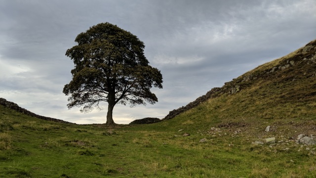
Sycamore Gap
Sycamore Gap is in Northumberland National Park in England.
A landmark gap in the Whin Sill caused by glacial meltwater wearing away the igneous rock.
A great hiking area along the Hadrian’s Wall path.
Created: 3 July 2021 Edited: 29 November 2023
National Trust Sycamore Gap Information
National Trust Sycamore Gap Address
Henshaw, Hexham, Northumberland
NE47 7
Website: https://www.nationaltrust.org.uk/holidays/peel-bothy-northumberland
Get directionsSycamore Gap LiDAR Map

Contains public sector information licensed under the Open Government Licence v3.0
Local History around Sycamore Gap
There are some historic monuments around including:
Medieval settlement and field system, two bastles and a corn drying kiln, immediately north east of Bradley HallVindolanda (Chesterholm) Roman forts, civil settlement and cemeteries, adjacent length of the Stanegate Roman road and two milestonesRound cairn, 120m ENE of Kingscrag GateHaltwhistle Burn 1 Roman temporary camp, fortlet and section of the StanegateDefended settlement and Roman signal station 410m south of West CrindledikesThe vallum and early Roman road between the field boundary east of turret 34a and the field boundary west of milecastle 36 in wall miles 34, 35 and 36Housesteads fort, section of Wall and vallum between the field boundary west of milecastle 36 and the field boundary west of turret 37a in wall miles 36 and 37Round cairn 380m north of Codley GateRing cairn and shieling immediately west of Chatley CragsHaltwhistle Burn Roman temporary camps 2 and 3 and area of cord rig cultivationRound cairn, 120m south of King's CragsRound cairn, 150m ESE of Kingscrag GateHadrian's Wall and vallum between the road to Caw Gap and the Caw Burn in wall miles 41 and 42The vallum between the road to Steel Rigg car park and the road in Caw Gap in wall miles 39, 40 and 41Camp in Oakwood SE of Plenmeller villageStaward peleStone circle, defended settlement, Romano-British farmstead and field system, Roman camp and group of shielings immediately south of Greenlee LoughSeatsides 1 Roman temporary camp and section of the Stanegate Roman road from the west side of the road from Once Brewed to the south side of the B6318Prehistoric settlement 230m north of BradleyRomano-British farmstead, 250m east of King's CragsHadrian's Wall, associated features and a Romano-British settlement between the road to Steel Rigg car park and the road through Caw Gap in wall miles 39 to 41Three prehistoric and Romano-British settlements and associated cord rig at Green BraeBowl barrow 420m south west of New BeggarbogMilestone House Roman temporary camp and section of the Stanegate Roman roadBastle at Grandy's KnoweShieling and associated building 1.45km west of Blue HemmelSeatsides 2 Roman temporary campThe vallum and a British settlement between the field boundary west of turret 37a and the road to Steel Rigg car park, in wall miles 37, 38 and 39Round cairn 450m north east of East CrindledikesCawfields Roman temporary campStone circle, 380m east of King's CragsBean Burn 1 Roman temporary campMare and Foal stone circle, 400m north east of Milestone HouseHadrian's Wall and associated features between the field boundary west of turret 37a and the road to Steel Rigg car park in wall miles 37, 38 and 39Willimontswyke (uninhabited portions)Twice Brewed Roman temporary campRound cairn, 150m east of Kingscrag GateHaltwhistle Burn 4 Roman temporary campBean Burn 2 Roman temporary campRoman quarry inscription on Queen's Crags, 680m south east of East Hotbank.


