Saltaire by kelvinjay
Saltaire
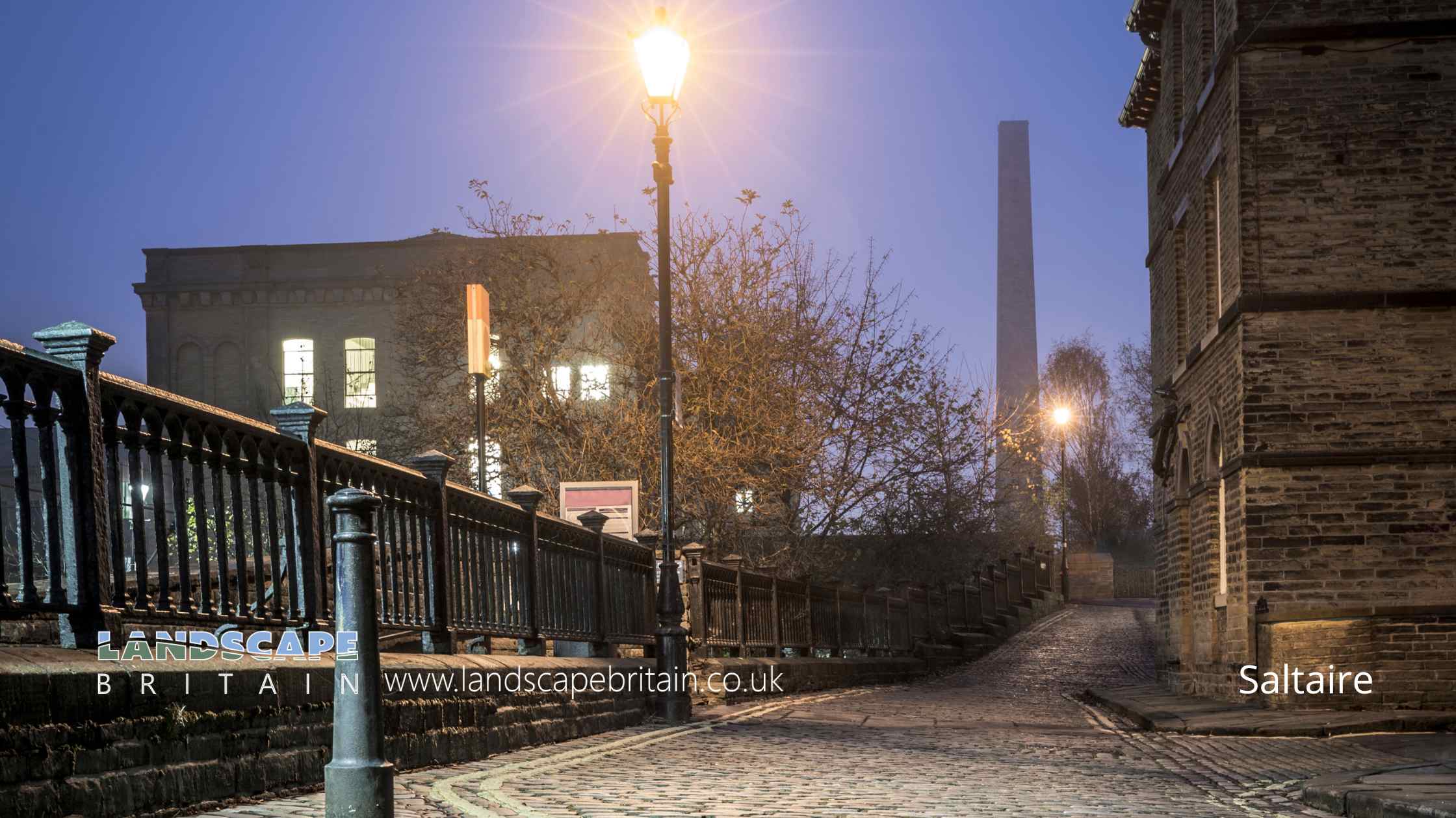
Saltaire, a UNESCO World Heritage Site located in the Bradford district of West Yorkshire, is a remarkable testament to 19th-century industrial and social history. Founded in 1851 by Sir Titus Salt, a leading industrialist in the wool industry, Saltaire was built as a model village for the workers of his enormous textile mill, Salts Mill. This visionary development was distinct in its time for providing much better living conditions than were typically available to mill workers. Saltaire’s layout was meticulously planned, with neat rows of stone houses, communal facilities like a hospital, library, and school, and social institutions including a park, a church, and a concert hall, reflecting Salt’s paternalistic and holistic approach to employee welfare.
The architecture of Saltaire, with its Victorian-era buildings, cobbled streets, and the grand Italianate mill complex, offers a window into the ambitions and social philosophy of the Victorian industrial age. Salts Mill itself, once the heart of the village’s economic life and now converted into a vibrant cultural hub, houses galleries, shops, and cafes. Notably, it includes an extensive collection of works by the local artist David Hockney, bringing a contemporary touch to the historical setting. Saltaire’s preservation as a UNESCO site underscores the global importance of this well-preserved example of industrial heritage, where urban planning, industry, and community life were interwoven.
Today, Saltaire’s charm not only lies in its historical and architectural significance but also in the lively sense of community and culture that thrives here. Annual events like the Saltaire Festival bring the streets to life with music, art, and food, drawing visitors from across the region and beyond. The village doesn’t just bask in its historic glory but continues to evolve, with a range of independent shops, eateries, and galleries dotting its streets, offering a contemporary twist to the industrial-age ethos of the village. For visitors, a stroll along the Leeds and Liverpool Canal or a wander through the beautifully maintained Roberts Park provides a peaceful contrast to the urban energy of nearby Bradford. In combining historical significance with modern vitality, Saltaire stands not only as a monument to a bygone era but as a living community, continually adapting and thriving in the 21st century.
Created: 27 October 2023 Edited: 5 January 2024
Saltaire
Local History around Saltaire
There are some historic monuments around including:
Rock with single cup near track north of Drake HillRock with large number of cup marks south of Dobrudden caravan parkCup and groove marked rock in boulder walling between Southpiece Cottage and Bleach MillNorthernmost of two cairns east of Glovershaw quarry, including adjacent cup-marked rockCairnfield with rubble banks and carved rocks above Stead CragRock with dense concentration of cup marks on Stanbury HillCairn on Hawksworth Moor; largest one of a group of cairnsCairn west of Craven Hall HillEnclosure on Woofa Bank with 11 carved rocks and one upright stoneCup marked rock 180m north of the covered reservoir at BaildonCup-marked rock west of confluence of Lodepit Beck and Glovershaw BeckCup-marked rock on slight bank north east of Glovershaw quarryRoadblock, Bracken Hall Green, Baildon MoorCup and ring marked rock north of Pennythorn HillRock with single cup near wall at Stead CragRock with single cup mark between road and Pennythorn HillEnclosed settlement known as `Soldier's Trench' including a cup-marked rockCarved rock in field behind Bracken Hall FarmSmall carved rock in path east of Glovershaw quarryCup and ring marked rock 42m south of Dobrudden caravan parkCup and ring marked rock in Dawson Wood, 370m north east of Heaton ShayCup marked rock in boulder walling between Southpiece Cottage and Bleach MillCup-marked rock in stone quarry on Stocks HillRing cairn 90m ESE of the Great Skirtful of StonesCup and ring marked rock at Hoyle Court Drive, CharlestownTwo adjacent carved rocks and associated rubble bank at top of ridge at Lanshaw overlooking Woofa BankRock with single cup mark south of Dobrudden caravan parkTwo carved rocks on northern slope of ridge at Lanshaw overlooking Woofa BankCup and groove-marked rock on east edge of Glovershaw quarryGrubstones stone circleGroup of five carved rocks on the western ridge of Stanbury HillCarved rock in Hawksworth SpringRock with two large cup marks on slope west of enclosure on Woofa BankCarved rock in the wall at north edge of Otley Road north west of the Fleece InnCarved rock near north east corner of Glovershaw quarryCup and groove marked rock in garden of Oakwood Barn, High EldwickRock with one cup mark north east of the Cricketers' Arms, Baildon GreenRock with shallow cup and ring-markings at the western end of the ridge on Stanbury HillCarved rock above Bracken Hall Crag, north of the bottom of the track to Mitton SpringEnclosure 50m north east of Horncliff Slade on Hawksworth MoorCarved rock with rounded triangular profile 48m NNW of enclosure on Woofa BankCup, ring and groove marked rock at the base of a wall between East Morton and West MortonRound cairn and curving bank on Pennythorn HillProminent cup-marked rock east of track, north east of Stanbury HillPrehistoric enclosure, carved rocks and orthostat wall, Buck Wood, 195m west of football groundBoulder with prehistoric rock art at Glovershaw FarmSmall cairn north east of large cairn on Hawksworth MoorCarved bedrock close to road north east of the public toilets on Bracken Hall GreenCup marked rock with triangular groove 75m east of enclosure on Woofa BankCairn known as the Little Skirtful of StonesCairnfield with linear banks and carved rocks stretching from Woofa Bank to Green CragTwo cairns on Hawksworth Moor, one with an internal cistRing cairn 475m south east of the Great Skirtful of StonesCup-marked rock between road and public toilets at Bracken Hall GreenCarved rock at east end of disused rifle rangeCup and ring marked rock east of Eaves Crag, Baildon MoorSouthernmost of two cairns east of Glovershaw quarryCup and ring marked rock at Lanshaw; 1km WSW of High Cragg FarmCup-marked rock close to road south east of a small car park south east of Bracken Hall Farm.Small cairn and carved rock on ridge at Lanshaw overlooking Woofa BankSmall cup-marked rock 30m east of Glovershaw quarryGrooved rock on slope at LanshawTwelve Apostles stone circle, Burley MoorSmall cup marked rock at eastern edge of a hollow 125m south east of the enclosure on Woofa BankCup and ring marked rock at Faweather Farm, High EldwickCup marked rock 60m south west of the War Memorial at Crowgill ParkWesternmost of two carved rocks under Green Crag west of gas pipelineCairnfield including ring cairn and carved rocks on Low Plain, Baildon MoorLate prehistoric enclosed settlement 150m north of Shaygate Farm, WilsdenLate prehistoric enclosed settlement in Crosley Wood, Bingley, 185m north of Scourer BridgeCup and groove marked rock north of Birch Close Farm house, High EldwickCup marked rock 71m south east of Dobrudden caravan parkLarge flat rock with single cup mark 20m north west of enclosure on Woofa BankCairn known as the Great Skirtful of StonesCup-marked bedrock near Old Glen HouseFive carved rocks in Cottingley Woods, 600m NNE of Lee FarmCup marked rock adjacent to wall near road from East Morton to West MortonSmall cup-marked rock on Stanbury Hill, 40m west of fork in pathCairn at Rombalds Moor triangulation pillarCarved rock east of track north of Drake HillCup and groove marked rock 32m south west of wall near Stead CragRound barrow and L-shaped earthwork on Baildon Golf CourseRock with parallel grooves 95m west of flag post on Craven Hall HillCup and ring marked rock at Lanshaw; easternmost of Lanshaw groupCup marked rock and round cairn south east of Dobrudden caravan parkCarved rock in spoil of shaft mound south east of Dobrudden caravan parkStriated cup marked rock 20m west of enclosure on Woofa BankRound cairn on east flank of Baildon HillCup and groove-marked rock north of Drake HillCup and groove marked rock between East Morton and West Morton.


