River Wharfe by munki-boy
River Wharfe
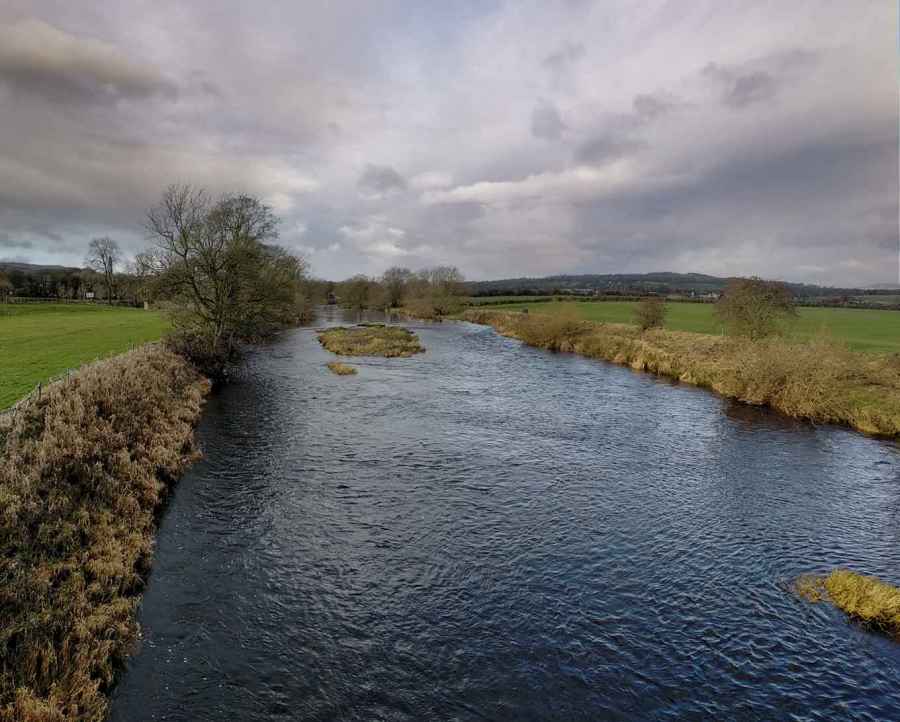
River Wharfe is in The Yorkshire Dales National Park in England.
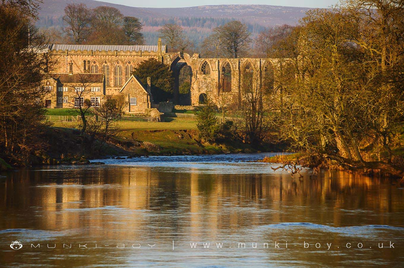
The River Wharfe flows through the beautiful limestone scenery of North Yorkshire for many miles with notable sections including The Strid, a series of dangerous rapids in contrast to the wide and sleepy section of the River Wharfe as it passes the ruins of Bolton Abbey.
Created: 8 November 2018 Edited: 29 November 2023
River Wharfe
Wharfe from Collingham Beck to Tadcaster Weir Details
Wharfe from Collingham Beck to Tadcaster Weir
Wharfe from Collingham Beck to Tadcaster Weir is a river in North Yorkshire
Wharfe from Collingham Beck to Tadcaster Weir takes in water from an area around 40.73 km2 in size and is part of the Wharfe Lower catchment area.
Wharfe from Collingham Beck to Tadcaster Weir is 18.272 km long and has been heavily modified by industry in the past.
Wharfe from Tadcaster Weir to River Ouse
Wharfe from Tadcaster Weir to River Ouse is a river in North Yorkshire
Wharfe from Tadcaster Weir to River Ouse takes in water from an area around 16.366 km2 in size and is part of the Wharfe Lower catchment area.
Wharfe from Tadcaster Weir to River Ouse is 14.616 km long and has been heavily modified by industry in the past.
Wharfe from R Washburn to Collingham Beck
Wharfe from R Washburn to Collingham Beck is a river in North Yorkshire
Wharfe from R Washburn to Collingham Beck takes in water from an area around 49.477 km2 in size and is part of the Wharfe Middle and Washburn catchment area.
Wharfe from R Washburn to Collingham Beck is 32.134 km long and is not designated artificial or heavily modified.
Wharfe from Barben Beck/River Dibb to Hundwith Beck
Wharfe from Barben Beck/River Dibb to Hundwith Beck is a river in North Yorkshire
Wharfe from Barben Beck/River Dibb to Hundwith Beck takes in water from an area around 102.71 km2 in size and is part of the Wharfe Middle and Washburn catchment area.
Wharfe from Barben Beck/River Dibb to Hundwith Beck is 35.385 km long and has been heavily modified by industry in the past.
Wharfe from Hundwith Beck to River Washburn
Wharfe from Hundwith Beck to River Washburn is a river in North Yorkshire
Wharfe from Hundwith Beck to River Washburn takes in water from an area around 49.4 km2 in size and is part of the Wharfe Middle and Washburn catchment area.
Wharfe from Hundwith Beck to River Washburn is 33.368 km long and has been heavily modified by industry in the past.
Wharfe from Oughtershaw Beck to Park Gill Beck
Wharfe from Oughtershaw Beck to Park Gill Beck is a river in North Yorkshire
Wharfe from Oughtershaw Beck to Park Gill Beck takes in water from an area around 54.761 km2 in size and is part of the Wharfe Upper catchment area.
Wharfe from Oughtershaw Beck to Park Gill Beck is 23.21 km long and is not designated artificial or heavily modified.
Wharfe from Park Gill Bk to Barben Beck/River Dibb
Wharfe from Park Gill Bk to Barben Beck/River Dibb is a river in North Yorkshire
Wharfe from Park Gill Bk to Barben Beck/River Dibb takes in water from an area around 48.209 km2 in size and is part of the Wharfe Upper catchment area.
Wharfe from Park Gill Bk to Barben Beck/River Dibb is 17.054 km long and is not designated artificial or heavily modified.
Local History around River Wharfe
There are some historic monuments around including:
Rock with at least two cup marks at the east end of a group of rocks 40m south of the track from Black Hill Road to New Dam, High Green, SkyreholmeRock with one cup mark 860m ENE of Wards End, Langbar MoorPartially quarried cup and groove marked rock between track and wall at east end of Foldshaw Ridge, 470m south of the shooting shelter, Middleton MoorCup, ring and groove marked rock at east end of the low ridge between Dryas Dike and Delves Beck 980m ESE of Wards End, Middleton MoorProminent rock with one cup mark at apex on ridge between Dryas Dike and Delves Beck 830m ESE of Blackhill House, Middleton MoorRock with at least five cup marks and a sinuous groove mark 615m NNE of Ridge Lathe, Pinder Hawes Hill, SkyreholmeRock with seven cup marks enclosed by a groove south of Foldshaw Ridge, 490m south of shooting shelter, Middleton MoorA group of seven carved rocks and four small cairns, south of Eller Edge Nook and 730m ENE of High Lathe, SkyreholmeRock with 30 to 40 cup marks and some groove marks in the wall at the west side of Black Hill Road, 610m ESE of New Dam, SkyreholmeThree carved rocks on Long Ridge 420m south east of Wards End, Middleton MoorRock with at least 30 cup marks, some joined by groove marks, near gate into Larnshaw from Forest Road, 420m north of High Lathe, SkyreholmeRock with cup marks and long groove 750m ESE of Blackhill House, Middleton MoorBolton PrioryThree carved rocks near grouse butts on Foldshaw Ridge 870m ESE of Wards End, Middleton MoorRock with seven to eight cup marks north of Dryas Dike 720m ESE of Wards End, Middleton MoorFive carved rocks grouped between Dryas Dike and Delves Beck 840m ESE of Blackhill House, Middleton MoorRing cairn on Kail Hill 380m north east of High Woodhouse.Barden Tower medieval fortified house and medieval garden earthworksRock with at least eight cups and two long grooves on ridge between Dryas Dike and Delves Beck 870m ESE of Blackhill House, Middleton MoorRound barrow 500ft (150m) NNW of Marchup Plantation in Parson's LaneCairn on west flank of High Black Hill, 210m ENE of the shooting shelter in Middleton Moor EnclosureCup marked rock and small cairn between Dryas Dike and Foldshaw Ridge 730m ESE of Wards End, Middleton MoorCup and groove marked rock, 310m north east of the shooting shelter in Middleton Moor EnclosureRock with at least 13 cup marks 645m NNE of Ridge Lathe, Pinder Hawes Hill, SkyreholmeRock with four cup marks near relict walling north of Dryas Dike 710m ESE of Wards End, Middleton MoorCup marked rock and cairn near path 775m ESE of Blackhill House, Middleton MoorRock with at least 14 cup marks 26m north of track from New Dam to Black Hill Road at east end of group of carved rocks on High Green, SkyreholmeAnglo-Saxon cemetery and medieval manorial centre including fishponds and part of the open field system adjacent to St Peter's ChurchDevil's Apronful cairnRound Hill, round barrow 1/2 mile (800m) NNE of Upper Austby FarmCup and ring marked rock between track and grouse butt north of Dryas Dike, 620m south of the shooting shelter, Middleton MoorTwo cup marked rocks 40m north of track from New Dam to Black Hill Road at centre of group of carved rocks at High Green, SkyreholmeRock with cup marks and short groove 740m ESE of Blackhill House, Middleton MoorRock with a complex design of small cup marks and shallow grooves south of Foldshaw Ridge, 440m south of the shooting shelter, Middleton MoorLate prehistoric enclosed settlement known as Round Dykes Camp on Addingham Low MoorCup marked rock north of track at east end of Foldshaw Ridge, 470m SSE of the shooting shelter in Middleton Moor EnclosureRing cairn 430m south west of Wood EndRock with one large cup mark on the south slope of High Black Hill, 330m east of the shooting shelter in Middleton Moor EnclosureCup and groove marked rock on slope south of Delves Beck 870m east of Moor End Farm, Middleton MoorOld BridgeCup and groove marked rock on flat ground south of Foldshaw Ridge, 510m SSW of the shooting shelter, Middleton MoorRock with two cup marks 500m ESE of New Dam, Burhill, SkyreholmeChurchyard cross at the Church of St PeterRock with at least two cup marks 660m north east of Ridge Lathe, Burhill Kiln Allotment, SkyreholmeRock with two deep cup marks north of track along Foldshaw Ridge, 460m south west of the shooting shelter, Middleton MoorCup, ring and groove marked rock west of the path between Black Hill and Loftshaw Gill, 300m NNE of the shooting shelter in Middleton Moor EnclosureTwo carved rocks near wall 760m north east of Ridge Lathe, Burhill Kiln Allotment, SkyreholmeCup and groove marked rock near grouse butts on Foldshaw Ridge 905m ESE of Wards End, Middleton MoorSmall rock with four cup marks and a large hewn rock with one cupmark on Foldshaw Ridge 830m ESE of Wards End, Middleton MoorTwo cup marked rocks forming part of a group of prominent rocks known as Raven Stones on Rocking Moor, 500m WSW of BraeCup and ring marked rock known as Langbar Rock 750m ENE of Wards End, Langbar MoorRock with at least five cup marks on low ridge north of track on High Green, 220m ESE of Nussey Green Lathe, SkyreholmeMedieval settlement and part of the open field system immediately south of Myddleton LodgeTwo carved rocks, one dome-shaped and one ridged, near grouse butts on Foldshaw Ridge 880m ESE of Wards End, Middleton MoorTwo cup marked rocks between Dryas Dike and Delves Beck 810m ESE of Blackhill House, Middleton MoorRock with cup marks in south east face near grouse butts on Foldshaw Ridge 860m ESE of Wards End, Middleton MoorCup and groove marked rock at west end of a group of carved rocks 30m north of track from New Dam to Black Hill Road, High Green, SkyreholmeRock with many cup marks on ridge between Dryas Dike and Delves Beck 880m ESE of Blackhill House, Middleton MoorLate prehistoric enclosed settlement with an outlying bank and ditch on Counter Hill, 220m north east of Moorcock HallRock with at least 24 cup marks, many interconnected by groove marks, 345m north west of High Lathe, Burnetts Ridge, SkyreholmeRock with one cup mark in track at east end of Foldshaw Ridge, 480m SSE of the shooting shelter in Middleton Moor EnclosureCup, ring and groove marked rock on south slope of High Black Hill, 350m east of the shooting shelter in Middleton Moor EnclosureCarved rock and two cairns 180m ESE of the shooting shelter, Middleton Moor EnclosureFancarl Top stone circleLarge rock with cup marks and cup and ring on Foldshaw Ridge 810m ESE of Wards End, Middleton MoorChurchyard cross, BurnsallLow Moor round barrowRock with a complex pattern of cup, ring and groove marks, 755m NNE of Ridge Lathe, Burhill Kiln Allotment, SkyreholmeRock with many cup marks and one groove between Dryas Dike and Delves Beck 910m ESE of Blackhill House, Middleton MoorRock with at least four large cups and a groove north of Dryas Dike 800m ESE of Wards End, Middleton Moor.