Reva Reservoir
Reva Reservoir
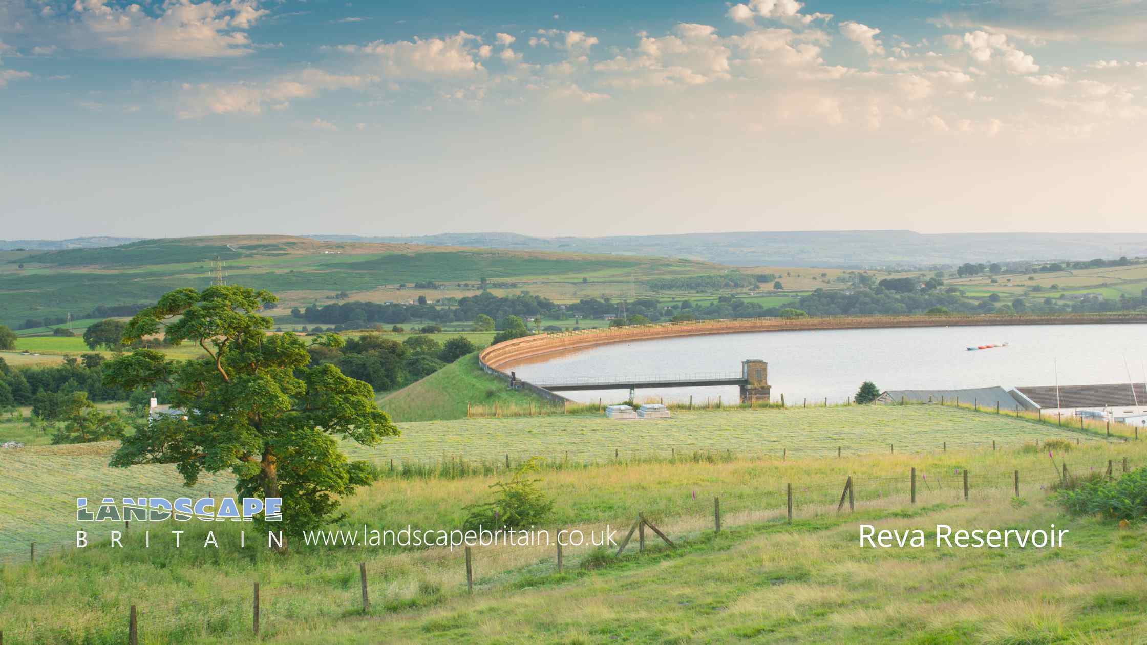
Reva Reservoir, located in the picturesque outskirts of Leeds, stands as a testament to the harmonious blend of natural beauty and man-made ingenuity. This tranquil body of water, nestled amidst lush greenery, has become a cherished spot for locals and visitors alike, seeking solace away from the bustling city life.
The reservoir’s origins trace back to the early 20th century, designed primarily to meet the increasing water demands of the growing population in Leeds. Over the years, it has evolved into more than just a functional water source; it has become a hub for outdoor activities and a sanctuary for wildlife. The area around Reva Reservoir is adorned with well-maintained walking paths, offering serene walks with picturesque views of the water and surrounding landscape. These paths are frequented by walkers, joggers, and nature enthusiasts, all drawn by the reservoir’s captivating charm.
Birdwatching is a particularly popular activity at Reva Reservoir, as it serves as a haven for a variety of bird species. The calm waters and the rich biodiversity in the surrounding flora create an ideal environment for these birds. Ornithologists and casual birdwatchers alike can spot a range of species, from common waterfowls to rare migratory birds, particularly during the changing seasons.
Apart from its natural allure, Reva Reservoir plays a crucial role in local water management. It is an integral part of Leeds’ water supply network, ensuring the city’s residents have access to clean and safe water. The reservoir’s design and maintenance are a testament to the city’s commitment to sustainable living, balancing the needs of its population with the preservation of natural habitats.
In recent years, there has been a growing emphasis on the conservation of the area surrounding Reva Reservoir. Efforts are being made to maintain the ecological balance, protect wildlife, and ensure that the reservoir remains a beautiful and safe environment for future generations. These initiatives reflect a broader trend in the UK towards environmental stewardship and sustainable community development.
Reva
Reservoir also holds a cultural significance for the community of Leeds. It’s not just a place for leisure and nature appreciation, but also a space where people come together, creating a sense of community and belonging. The area is often the setting for educational trips, where schoolchildren learn about local ecology and the importance of water conservation. It serves as a practical example of how urban and natural environments can coexist in harmony.
The management of Reva Reservoir is a prime example of responsible environmental stewardship. The authorities in Leeds ensure that the reservoir and its surrounding areas are kept clean and well-maintained. This approach not only preserves the natural beauty of the area but also ensures the sustainability of the reservoir as a vital resource for the city.
As the seasons change, the landscape around Reva Reservoir transforms, offering a diverse array of scenic views throughout the year. In spring, the area bursts into life with blooming flowers and budding trees, while autumn brings a palette of warm colours that cloak the surrounding woodlands. Winter often sees the reservoir enveloped in a serene, frosty beauty, making it a picturesque winter wonderland.
In conclusion, Reva Reservoir is more than just a body of water near Leeds; it is a symbol of the balance between urban development and natural preservation. It offers a peaceful retreat, a hub for community activities, and a vital resource for the city. As such, it holds a special place in the hearts of those who visit and underscores the importance of protecting our natural environments for the well-being of our communities.
Created: 12 January 2024 Edited: 26 May 2024
Reva Reservoir Details
Reva Reservoir is a very small freshwater lake in West Yorkshire, situated at an altitude of around 231 meters and is shallow.
The shoreline of Reva Reservoir is approximately 1.038 Kilometers all the way round.
- Altitude: 231 m
- Shoreline: 1.038 Km
- Depth: Shallow
Reva Reservoir
Local History around Reva Reservoir
There are some historic monuments around including:
Cup marked rock in field south of Stead Hall FarmCairn 6m in diameter south of track east of plantation on Weston Moor 300m WNW of Weston Moor CottageCarved rock in field behind Bracken Hall FarmCarved rock near north east corner of the plantation on Weston Moor 550m north west of Weston Moor CottageCup-marked rock close to road south east of a small car park south east of Bracken Hall Farm.Cup marked rock 39m south east of entrance to Silver Well CottageCarved rock above Bracken Hall Crag, north of the bottom of the track to Mitton SpringGroup of five carved rocks on the western ridge of Stanbury HillCup-marked rock west of confluence of Lodepit Beck and Glovershaw BeckCarved rock on Cranshaw Thorn Hill above Ilkley Crags, 560m west of Gill Head ReservoirCup and ring marked rock in Dawson Wood, 370m north east of Heaton ShaySmall cup-marked rock on Stanbury Hill, 40m west of fork in pathRock with cup marks 33m north east of Green Crag EnclosureCarved rock between Backstone Beck and the path to Gillhead 365m south west of Gill Head ReservoirCup marked rock with triangular groove 75m east of enclosure on Woofa BankSouthernmost of two cairns east of Glovershaw quarryCup marked rock 71m south east of Dobrudden caravan parkRock with one cup mark north east of the Cricketers' Arms, Baildon GreenCup marked rock east of entrance to Silver Well CottageRing cairn 90m ESE of the Great Skirtful of StonesRock in Panorama Woods with single cup and ring carvingRock with at least seven cup marks at edge of track on Stoop Hill, 890m SSE of triangulation point on Shooting House Hill, Askwith MoorCup-marked rock on slight bank north east of Glovershaw quarryCarved rock in spoil of shaft mound south east of Dobrudden caravan parkGrooved rock and cup and ring marked rock 420m east of Badger StoneCairn 7m in diameter north of track east of plantation on Weston Moor 450m WNW of Weston Moor CottageNorthernmost of two cairns east of Glovershaw quarry, including adjacent cup-marked rockCarved rock in the wall at north edge of Otley Road north west of the Fleece InnLarge carved boulder on eminence between two streams east of Barmishaw WellCarved rock at east end of disused rifle rangeOld BridgeCup marked rock on slope south of Green Crag EnclosureCairn on Hawksworth Moor; largest one of a group of cairnsSmall cairn north east of large cairn on Hawksworth MoorCairnfield including ring cairn and carved rocks on Low Plain, Baildon MoorRock with large number of cup marks south of Dobrudden caravan parkCup and groove-marked rock on east edge of Glovershaw quarryBoulder with prehistoric rock art at Glovershaw FarmMedieval settlement and part of the open field system immediately south of Myddleton LodgeCarved rock near north east corner of Glovershaw quarryCup and ring marked rock at Hoyle Court Drive, CharlestownCup and ring marked rock east of Eaves Crag, Baildon MoorTwo adjacent carved rocks and associated rubble bank at top of ridge at Lanshaw overlooking Woofa BankGrooved rock on slope at LanshawCairnfield with linear banks and carved rocks stretching from Woofa Bank to Green CragCup and ring marked rock at Lanshaw; easternmost of Lanshaw groupCairn known as the Great Skirtful of StonesSmall cup marked rock at eastern edge of a hollow 125m south east of the enclosure on Woofa BankGrubstones stone circleCarved rock 100m north east of eastern Grainings Head QuarryCup-marked bedrock near Old Glen HouseCarved rock in a valley on south side of Cranshaw Thorn Hill 460m WSW of Gill Head ReservoirCarved rock on Cranshaw Thorn Hill above Ilkley Crags, 465m west of Gill Head ReservoirRock with two large cup marks on slope west of enclosure on Woofa BankRock with at least two cups and a groove east of the plantation on Weston Moor 450m north west of Weston Moor CottageTwo fragments of carved bedrock east of Crocodile Rock, near west end of Hangingstones QuarryEnclosure with carved rocks and disturbed cairn known as Green Crag EnclosureTwelve Apostles stone circle, Burley MoorCup marked rock on low knoll west of and overlooking Cow and Calf HotelRock with dense concentration of cup marks on Stanbury HillSite of Roman Fort, Ilkley.Cup and ring marked rock 42m south of Dobrudden caravan parkRock with parallel grooves 95m west of flag post on Craven Hall HillTwo cairns on Hawksworth Moor, one with an internal cistCup marked rock 60m south west of the War Memorial at Crowgill ParkEnclosure, fieldwalls and cairnfield, including seven carved rocks and an upright stone.Cup and grooved marked rock in tree line between New Close Quarry and Poppling Well Beck, 280m south west of Whitbeck ManorCup and groove marked rock north of Birch Close Farm house, High EldwickRock with two cup marks south east of quarry at Cow and Calf RocksCarved rock next to the drive of Overdale Nursing HomeLarge cup marked rock west of Green Crag EnclosureCarved rock 70m south west of Gill Head ReservoirCarved rock 80m NNE of Badger StoneCarved rock in Hawksworth SpringCarved rock known as the Barmishaw StoneCup and ring marked rock between Keighley Gate and Silver Well CottageSection of rubble walling east of Grammar School Cairn, on Cranshaw Thorn HillRock with shallow cup and ring-markings at the western end of the ridge on Stanbury HillRound barrow and L-shaped earthwork on Baildon Golf CourseCarved rock and associated prehistoric walling above Backstone Beck, 200 WNW of Gill Head ReservoirCup and ring marked rock 90m WSW of Gill Head ReservoirCarved rock in strip of trees on north side of track from Stead to Burley in WharfedaleRock with one cup mark east of the plantation on Weston Moor 380m north west of Weston Moor CottageRock with single cup mark between road and Pennythorn HillCarved rock east of track north of Drake HillRock with three cupmarks west of West Rock and 225m south of White WellsCup and ring marked rock between Spicey Gill and the Ilkley-Keighley roadCairn known as the Little Skirtful of StonesLarge rock with single cup mark 130m south east of and overlooking Green Crag EnclosureSmall cup-marked rock 30m east of Glovershaw quarrySmall cairnfield with carved rocks north of the plantation on Weston Moor centred 730m north west of Weston Moor CottageRock with single cup near track north of Drake HillGatepost with cup marks and grooves 350m SSE of West Moor House, at side of road 500m west of Bow BeckCup and groove marked rock 32m south west of wall near Stead CragCup and ring marked rock at Lanshaw; 1km WSW of High Cragg FarmCup-marked rock in stone quarry on Stocks HillLarge rock with single cup mark at point where path through Green Crag Enclosure reaches top of slopeRoadblock, Bracken Hall Green, Baildon MoorRound cairn on east flank of Baildon HillTwo cup marked rocks 220m west of Highfield HouseStriated cup marked rock 20m west of enclosure on Woofa BankRock with large oval cup east of plantation on Weston Moor 830m WSW of Dob Park House FarmCarved rock with rounded triangular profile 48m NNW of enclosure on Woofa BankCup marked rock and round cairn south east of Dobrudden caravan parkGroup of four carved rocks in Panorama WoodsCairnfield, carved rocks and associated curved bank at north west end of Green Crag Slack, east of Gill Head ReservoirCairn west of Craven Hall HillCairnfield with rubble banks and carved rocks above Stead CragCup and ring marked rock north of Pennythorn HillCup and ring marked rock 340m east of Badger StoneProminent cup-marked rock east of track, north east of Stanbury HillCarved rock known as Pepperpot Rock and adjacent small carved rock west of West Rock and 215m south of White WellsRing cairn 475m south east of the Great Skirtful of StonesCup and ring marked rock 300m NNW of Gill Head ReservoirCup, ring and groove marked rock south of track on Weston Moor 500m WNW of Weston Moor CottageCup marked rock 180m north of the covered reservoir at BaildonCarved rock with multiple rings in path above the Cow and Calf Hotel, 180m west of Highfield HouseCup and groove-marked rock north of Drake HillEnclosed settlement containing three carved rocks known as Backstone Beck EnclosureA 17th century park lodge known as Dobpark Lodge in Dob Park, near OtleyCup and groove marked rock in boulder walling between Southpiece Cottage and Bleach MillEnclosure on Woofa Bank with 11 carved rocks and one upright stoneRock with five cups near Haystack RockCup and Ring marked rock known as the Hanging Stone RockSmall carved rock in path east of Glovershaw quarryRock with single cup mark south of Dobrudden caravan parkLarge flat rock with single cup mark 20m north west of enclosure on Woofa BankLate prehistoric enclosed settlement in Crosley Wood, Bingley, 185m north of Scourer BridgeCarved rock 110m north east of Badger StoneEnclosures, small cairnfield and carved rocks on Pancake RidgeCup and ring marked rock at Faweather Farm, High EldwickThree carved rocks opposite St Margaret's ChurchWesternmost of two carved rocks under Green Crag west of gas pipelineRock with five or more cups south of track on Weston Moor 300m WNW of Weston Moor CottageTwo carved rocks near Neb StoneSmall cairn and carved rock on ridge at Lanshaw overlooking Woofa BankCup marked rock 200m west of Cow and Calf HotelCarved rock south east of entrance to Silver Well CottageCarved rock known as Planets Rock 180m north east of the Gill Head ReservoirCup and groove marked rock east of New Close Quarry, 300m south west of Whitbeck ManorCup marked rock in boulder walling between Southpiece Cottage and Bleach MillCarved rock known as the Badger StoneEnclosure 50m north east of Horncliff Slade on Hawksworth MoorRock with at least eight cups south of track on Weston Moor 480m WNW of Weston Moor CottageCup marked rock lying 200m south of and above White WellsCarved bedrock close to road north east of the public toilets on Bracken Hall GreenRound cairn and curving bank on Pennythorn HillCup and ring marked rock 10m south of West RockEnclosed settlement known as `Soldier's Trench' including a cup-marked rockTwo carved rocks on northern slope of ridge at Lanshaw overlooking Woofa BankCarved rock in wall of grounds of Overdale Nursing HomeCup marked rock 230m south of and above White WellsCup and ring marked rock overlooking bend in Ilkley-Keighley road, 185m south east of Neb StoneRock with single cup near wall at Stead CragCup-marked rock between road and public toilets at Bracken Hall GreenPrehistoric enclosure, carved rocks and orthostat wall, Buck Wood, 195m west of football groundCarved rock 80m east of Green Crag EnclosureTwo cup marked rocks in path south east of quarry at Cow and Calf RocksCairn at Rombalds Moor triangulation pillarCup and groove marked rock in garden of Oakwood Barn, High Eldwick.Wildlife in and around Reva Reservoir
Reva Reservoir Birds
There are 166 species of birds recorded as found near Reva Reservoir.
| Bar-Headed Goose (Anser indicus) |
| Barnacle Goose (Branta leucopsis) |
| Black Swan (Cygnus atratus) |
| Black-Headed Gull (Chroicocephalus ridibundus) |
| Blackcap (Sylvia atricapilla) |
| Barn Owl (Tyto alba) |
| Black Grouse (Tetrao tetrix) |
| Black Tern (Chlidonias niger) |
| Blackbird (Turdus merula) |
| Blue Tit (Cyanistes caeruleus) |
Tap here for more wildlife found near Reva Reservoir lake


