Milfield North Henge by munki-boy
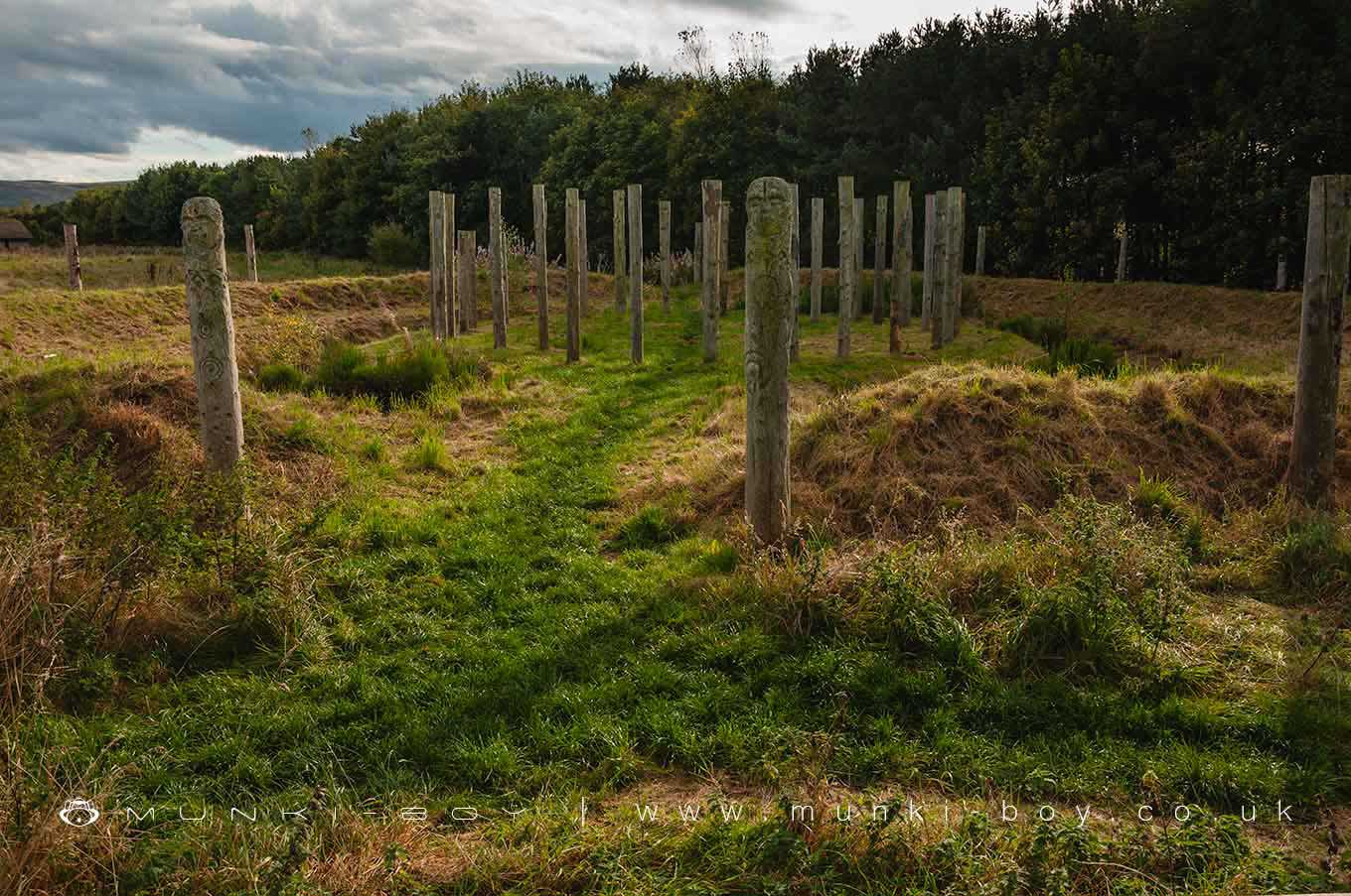
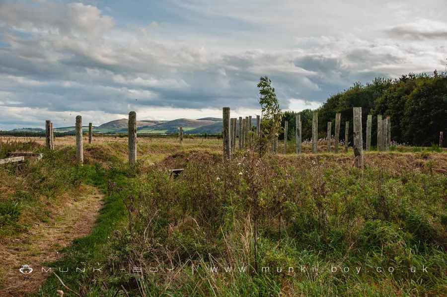
Milfield North Henge
A reconstructed henge based on a nearby (100m) excavated henge monument dating to 2300BC.
I the central area of the henge three ancient burial pits were found, one containing a food vessel and burial the other two were too degraded. A stone cist was also found near the ‘entrance’ to the central area.
The henge was later used by the Anglo-Saxons as a burial place.
Created: 22 March 2020 Edited: 29 November 2023
Maelmin Henge and Trail
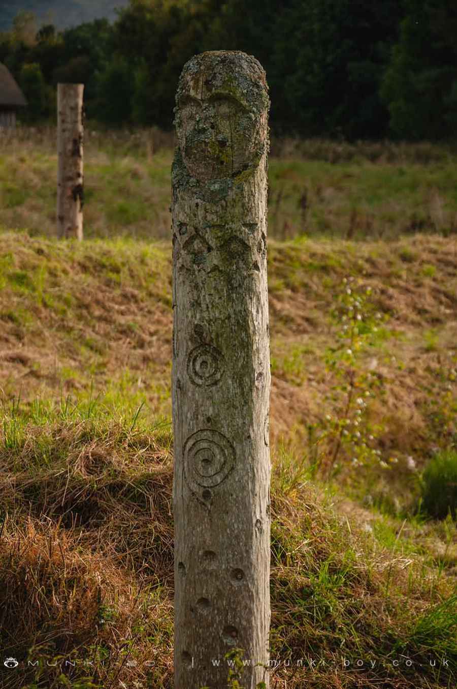
Reconstructed Wooden Post at Milfield North Henge
Maelmin Henge and Trail Information
Maelmin Henge and Trail Address
Milfield, Wooler
NE71 6HR
Website: https://www.maelmin.org.uk/index.php?page=the-henge
Get directionsMilfield North Henge LiDAR Map

Contains public sector information licensed under the Open Government Licence v3.0
Local History around Milfield North Henge
There are some historic monuments around including:
Rock art including four animal carvings at Goatscrag rock shelter, 155m north west of Routin LynnPrehistoric field system and cairnfield east of Watch Hill, 520m NNE of footbridge over Carey BurnPrehistoric enclosed settlement, Iron Age hillfort and medieval shielings on Humbleton HillFordwood camp, Broomridge DeanSettlement at the south end of The BellRomano-British farmstead and part of an associated field system 630m south west of White GablesCamp 400yds (370m) NNE of FloddenMedieval shieling and enclosure 340m north west of GleadscleughEtal Castle tower houseRomano-British farmstead 900m north east of triangulation point on Gains LawPrehistoric field system, cairnfield, round cairns and enclosed cremation cemetery on east slopes of Fredden Hill, 750m west of Wooler CommonWest Hill campGlead's Cleugh Iron Age promontory fortUnenclosed stone hut circle settlement 120m north west of GleadscleughHethpool tower houseFlodden campHowtel tower houseParson's TowerSettlement, probably medieval, SW of TorleehouseIron Age defended settlement and cultivation terraces 600m north east of Brown's Law CottageYeavering Bell campHethpool stone circlesSt Gregory's Hill campSite SE of YeaveringRomano-British farmstead 630m south west of White GablesPrehistoric hut circle 540m south of GleadscleughRomano British settlement, 655m north east of Lanton Hill MonumentBronze Age field system on Fredden HillCastle Hill campSettlement on north east slope of Yeavering BellMultivallate hillfort, at Fenton HillIron Age multivallate hillfort and prehistoric trackway at Monday CleughThe Battle StoneRock art at Goatscrag, 200m north west of Routin LynnHenge, pit-circle and later cemetery, 850m north east of Millfield HillPrehistoric unenclosed hut circle settlement, field system and cairnfield 340m south west of triangulation point on Gains LawDefended settlement on north slope of Harehope Hill, 570m south east of High Akled CottagesSite SW of ThirlingsFord Colliery 920m north east of Blackcrag WoodBronze Age round house on Fredden Hill 880m south west of Bell's ValleyAd Gefrin Anglo-Saxon township and prehistoric remainsRomano-British settlements E of Yeavering Bell containing the Old Sheepfold settlement and settlements to the W and S of itPrehistoric unenclosed hut circle settlement west of Monday Cleugh, 520m SSE of GleadscleughTwo Roman period native settlements and associated field system on Coldberry HillRoman period native settlement 340m east of Hethpool LinnRomano-British native farmstead 970m north east of triangulation point on Gains LawTwo medieval shielings on Akeld Hill, 680m WNW of GleadscleughSettlement 500yds (460m) SW of White LawBronze Age cairnfield on north west slopes of Hart Heugh, 900m south west of Wooler CommonMarley Knowe round cairnFarmstead and cultivation terraces, ENE of StawhouseSettlement on north slope of Yeavering BellTwo incised rocks on Broom Ridge, Hunter's MoorHazely Hill round cairnThree Roman period native settlements and later droveway 750m south west of TorleehouseCairnfield 420m south east of triangulation point on Gains LawSettlement N of White LawBronze Age unenclosed hut circle settlement, field system and cairnfield, 630m south west of triangulation point on Gains LawMedieval chapel, 220m south east of White GablesSettlement, field systems and terraces on the south east slope of Yeavering BellRound cairn 100m south of TorleehouseRoman period native homestead 400m south of Humbleton Hill hillfortUnenclosed scooped settlement on the east slope of Harehope Hill, 750m south east of High Akeld CottagesHut circle 770m south east of White GablesRoman period native farmstead and associated scooped enclosures and trackways on east slope of Harehope Hill, 925m south east of High Akeld CottagesPrehistoric hut circle on Harehope Hill, 400m south east of GleadscleughRound cairn 760m south east of triangulation point on Gains LawCircular enclosure W of Second LinthaughHenge 600yds (550m) E of Akeld LodgeSite E of Milfield villageThe Battle Stone, 650m WNW of Yeavering FarmCoupland henge and section of droveway, 170m SSW of Cheviot CottageFlodden Edge campDefended settlement, 380m south west of Sandy HouseRoman period native settlement, associated field system and trackway, and medieval farmstead 270m south of TorleehouseEwart Park hengeDefended settlement on White Hill, 700m south east of KimmerstonSettlement on the east slope of The BellFord Westfield settlement.


