Maiden Castle by Blackbeck from Getty Images Signature
Maiden Castle
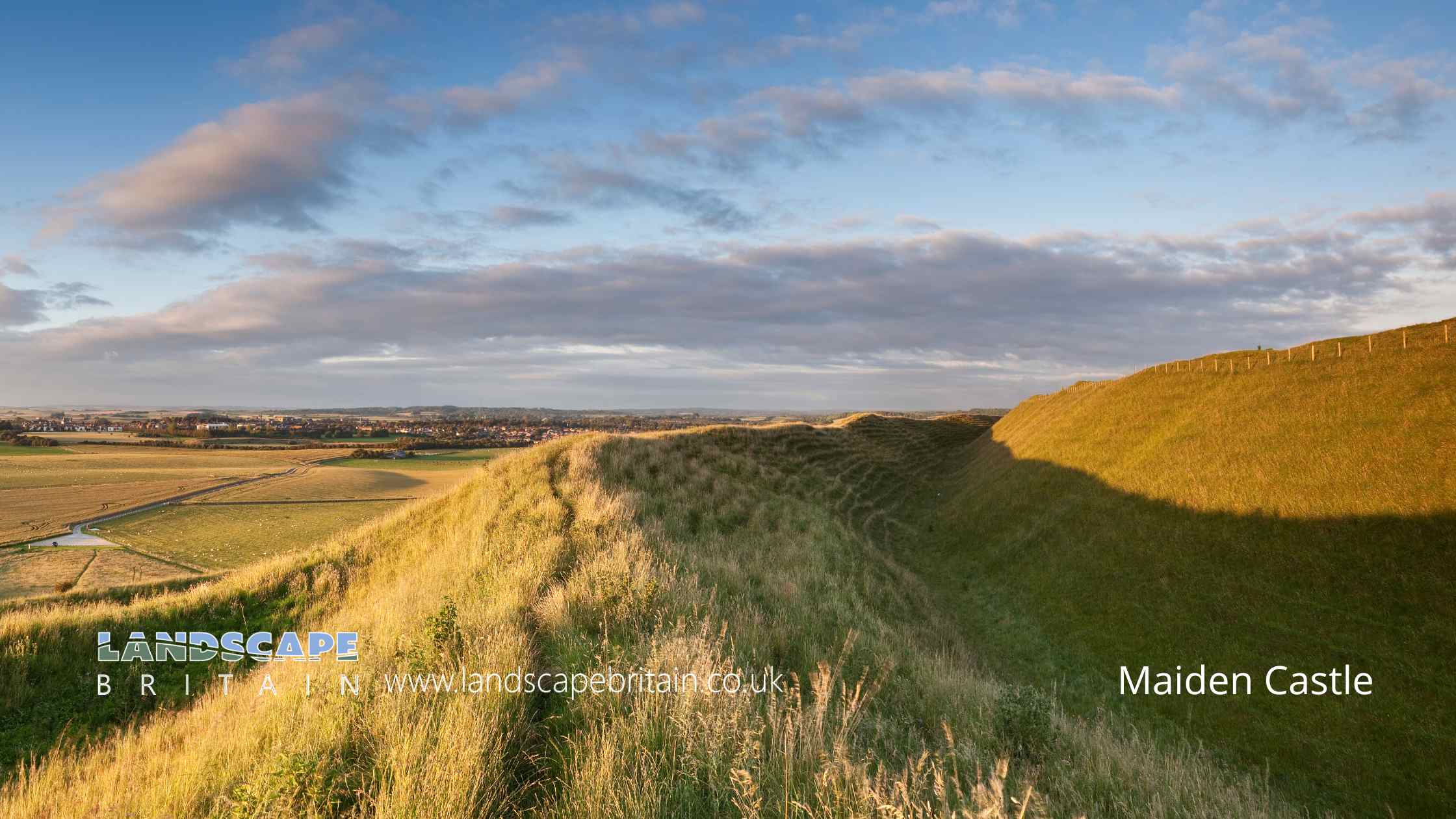
Maiden Castle in Dorset is a prominent archaeological site known primarily for its extensive Iron Age hillfort. Situated on a chalk hilltop in the South Dorset Downs, the site overlooks the valleys of the Frome and South Winterbourne rivers. Maiden Castle’s historical significance spans multiple periods, with evidence of occupation dating back to the Early Neolithic period around 4000 BC. Early excavations by Edward Cunnington in 1884 and Sir Mortimer Wheeler between 1934 and 1937, along with further investigations in the mid-1980s, have revealed a complex history of human activity and settlement at the site.
The earliest features identified at Maiden Castle include a series of pits across the hilltop, associated with Early Neolithic flintwork. These pits suggest that the hilltop was cleared of woodland around 4000 BC. Shortly thereafter, a causewayed enclosure was constructed on the eastern plateau, defined by two concentric lines of ditches. This enclosure, covering an area of about 8 hectares, may have contained a long barrow and was associated with two human infant burials. By around 3500 BC, the enclosure had fallen out of use, and a significant bank barrow was constructed, partly overlaying the earlier structure. This barrow, measuring 546 meters in length, indicates continued human activity on the hilltop into the Later Neolithic and Bronze Age periods, albeit likely at a reduced scale.
The Iron Age hillfort, which Maiden Castle is best known for, overlies the earlier Neolithic structures. Initially marked by a single rampart, the fort underwent several phases of expansion and remodelling. By the mid-2nd century BC, the fort’s defences consisted of three banks and two ditches encircling the hilltop, with additional fortifications on the gentler southern slope. The interior of the hillfort was densely occupied, as evidenced by the remains of circular and rectangular huts, roads, storage pits, and various domestic and industrial structures. Artefacts uncovered from this period include large quantities of Iron Age pottery, sling stones, brooches, beads, and tools, along with around 50 human burials, some accompanied by grave goods.
Following the Roman conquest, the hillfort’s prominence declined as the Roman town of Durnovaria (modern Dorchester) emerged nearby. Nevertheless, during the 4th century AD, a Romano-Celtic temple was built at the eastern end of the fort. This temple, constructed of flint and limestone, featured a central cella surrounded by a corridor and was adorned with mosaic floors and stone tiles. The precise dedication of the temple remains unknown, though it likely honoured a pagan deity.
In the post-Roman period, Maiden Castle was used primarily for grazing livestock, with several dew ponds constructed to provide water. The hilltop saw agricultural use in the 17th century but has largely remained uncultivated in the past two centuries. Today, Maiden Castle stands as a testament to the long and varied history of human occupation and activity, reflecting the cultural and historical developments of the region over several millennia.
Created: 26 May 2024 Edited: 10 June 2024
Maiden Castle Details
Maiden Castle is a 135 metre high hill in Dorset.
Maiden Castle
Maiden Castle LiDAR Map
please wait...
Contains public sector information licensed under the Open Government Licence v3.0
Local History around Maiden Castle
There are some historic monuments around including:
Round barrow N of Ashton CottagesCross in St Mary's churchyardGroup of barrows on the golf course, Came DownTwo bowl barrows 720m south east of Friar Waddon HouseThree bowl barrows at the western end of Waterston Ridge, 360m north west of Fidler's Green FarmMulti-period archaeological landscape centred on and including a slight univallate hillfort called Chalbury, two bowl barrows, part of a Bronze Age urnfield and a series of medieval strip fieldsBowl barrow 850m north west of Whitefriars Broiler HousesRound barrow SW of Ashton CottagesTwo round barrows on North HillBowl barrow 700m NNW of Whitefriars Broiler HousesHenge, Romano-British amphitheatre and Civil War fieldworks known collectively as Maumbury RingsRound barrow on Pound HillRound barrow NW of Jackman's CrossBowl barrow on Wood Hill 310m north east of CowdenRomano-Celtic temple and associated remains at Jordan HillLong barrow and four bowl barrows 500m north west of Whitfield FarmBowl barrow on Little Puddle Hill, 920m north west of Fidler's Green FarmLong barrow, three bell barrows, fancy barrow and a linear earthwork 800m north of Maiden CastleBarrow S of Three-Cornered PlantationTwo round barrows S of Ashton FarmTwo round barrows on RidgewayBowl barrow185m WSW of Higher Skippet FarmThree barrows near Town Hill BarnThree barrows S of Hart Hill PlantationRound barrow SW of villageBowl barrow 500m north east of Clandon FarmRound barrows N of Pound HillTwo round barrows N of Came FarmTwo barrows at RewDisc barrow 715m west of Bayard FarmRound barrow SW of Pigeon House CottagesBarrows in Came WoodRound barrows on RidgewayMedieval settlement 850m north of St Mary's ChurchTwo barrows W of Little Piddle DownRound barrow cemetery immediately south east of Maiden CastleRound barrow NE of Hog Hill BarnDiscontinuous surviving sections of Roman aqueductBell barrow 70m west of Fidler's GreenRound barrow E of Bayard's BarnFour round barrows NW of Blagdon BarnTwo barrows on Little Puddle HillOuter defences of Roman town, W of St Genevieve's ConventMaiden CastlePreston Roman villaEarthwork N of Hampton PlantationsFour bowl barrows immediately north west of Maiden CastleTwo bowl barrows immediately south of Bayard DairySix round barrows W of Came DownGroup of round barrows on and to E of Great HillThree bowl barrows 530m and 350m north east of Whitcombe BarnOval barrow and three bowl barrows 250m and 330m south of Whitcombe BarnRound barrow in Grimstone ClumpsRound barrow 1/4 mile (400m) N of Ridge HillBarrow E of Red BarnGroup of round barrows near Eweleaze BarnBowl barrow 380m west of Whitfield FarmRound barrows on Four Barrow HillBowl barrow 400m north east of Manor Farm, part of the Pound Hill round barrow cemeteryBarrow on parish boundaryTwo bowl barrows on Conygar HillGroup of round barrows on Shorn Hill and Bronkham HillSix barrows on Ridgeway HillRound barrow N of RidgewayMulti-period landscape including an Iron Age or Romano British settlement, part of an associated field system, six bowl barrows and an enclosure 600m south east of Langford FarmRound barrow NE of Friar WaddonRound barrow N of Ballarat HouseSix round barrows on Bincombe DownFour bowl barrows on Hog Hill, west and north west of Maiden CastleMedieval settlement of Winterborne Farringdon and associated remainsFrampton Roman villaDorchester Roman wallsCross-ridge dyke on WindsbatchRound barrows W of Blagdon BarnPigeon House long barrowLong barrow NW of Red BarnHenge Enclosure, Conquer Barrow and Barrow CemeteryLong barrow 400yds (360m) NW of Hill BarnRound barrow E of Forston FarmRound barrow on Ridgeway HillHerringston round barrowsFriar Waddon Hill round barrowsRound barrow SW of Wolfeton ClumpRound barrows on Grove HillThree barrows N of Penn HillGroup of three round barrows NE of Jackman's CrossRound barrow on Stratton DownBowl barrow 360m south west of Clandon FarmGroup of four round barrows in Cripton WoodRound barrow E of The BuildingsHumpty Dumpty Field, RadipoleGroup of round barrows on Bincombe HillTwo round barrows at Down WoodThree round barrows E of Smitten CornerLangton Cross: a wayside cross 850m south west of Tatton HouseColliton Park Roman houseTwo round barrows N of Bincombe BarnBowl barrow 780m north east of Hampton FarmGroup of barrows on West HillPoundbury Camp, associated monuments and section of Roman aqueduct.Round barrow on Shorn HillLime kiln 800ft (245m) NW of Langton CrossBell barrow in Highfield Plantation and two bowl barrows immediately north west of Forty Acre PlantationGroup of barrows S of Goldsmith's PlantationGroup of round barrows on North Bincombe Hill, S of Came WoodThe Clandon Barrow, 450m west of Clandon FarmCulliford Tree long barrow and group of round barrowsPart of Roman, Saxon, and medieval town in grounds of Wollaston HouseTwo conjoined bowl barrows 550m north east of Manor FarmLong barrow immediately north west of Maiden CastleBarrow S of Wolfeton ClumpGroup of round barrows W of Ridgeway HillTwo round barrows on RidgewayBowl barrow 450m north east of Manor Farm, part of the Pound Hill round barrow cemeteryGroup of round barrows on RidgewaySettlement remains N of Maiden CastleRound barrow on Rew HillGroup of barrows in Seven Barrow Plantation.


