Loch Faskally
Loch Faskally, a stunning body of water formed by the Tummel Hydro-Electric Power Scheme in the 1950s, is a testament to the harmonious blend of natural beauty and human ingenuity in Scotland’s Perth and Kinross region. Situated on the River Tummel and encompassed by lush woodland and rolling hills, this loch extends over approximately 2.5 miles and is a central attraction in the area, particularly near the charming town of Pitlochry.
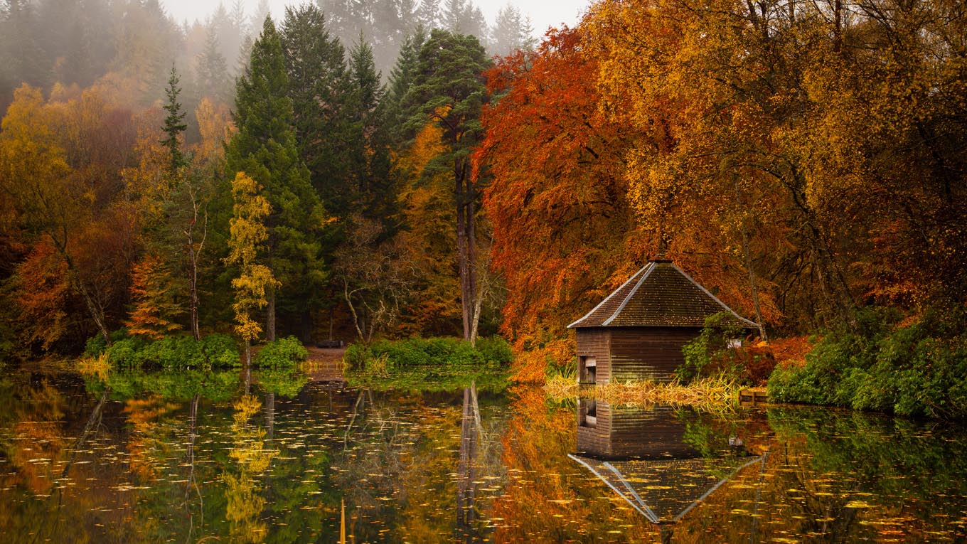
The loch’s serene waters reflect the verdant hues of the surrounding forestry, particularly striking during autumn when the foliage adopts fiery tones, creating a picturesque panorama that attracts photographers and nature enthusiasts alike. Beyond its visual allure, Loch Faskally is a hub for outdoor activities. Anglers are drawn to its well-stocked waters, teeming with salmon and trout, while the network of paths around the loch provides idyllic routes for walkers and cyclists eager to explore the scenic landscape.
Notably, the Pitlochry Dam, a feature of engineering prowess, stands at the eastern end of Loch Faskally. This dam, apart from generating hydro-electric power, features a salmon ladder, allowing visitors the unique opportunity to observe the fish as they ascend the river during breeding season. The ladder is designed to aid the salmon on their arduous journey upstream, ensuring the continuation of their lifecycle, much to the delight of conservationists and wildlife enthusiasts.
Loch Faskally, with its tranquil waters, scenic surrounds, and the rhythmic sound of the River Tummel, embodies a peaceful retreat and an invigorating adventure spot, offering visitors a chance to connect with nature’s splendor. Its presence continues to enhance the natural charm and environmental diversity of Perth and Kinross, making it a treasured destination for locals and tourists alike.
Created: 21 October 2023 Edited: 5 January 2024
Loch Faskally
Local History around Loch Faskally
There are some historic monuments around including:
Old Faskally Farm, church 100m WSW of Ecclesiastical: church SM9566Tullypowrie Burn,chapel,cross slab,farmstead and mill Crosses and carved stones: cross-incised stone; Ecclesiastical: church; Industrial: farming, food production; Secular: farmstead SM5446Druid, settlement and cultivation remains 600m E of Prehistoric domestic and defensive: field or field system SM4471Castle Dow,fort Prehistoric domestic and defensive: fort (includes hill and promontory fort) SM4432Sithean,cairn Prehistoric ritual and funerary: cairn (type uncertain) SM2383Balenduin, cairn 80m SE of Prehistoric ritual and funerary: barrow SM4318Dunfallandy Stone, cross slab Crosses and carved stones: cross slab SM90115Claverhouse's Stone, standing stone 200m S of House of Urrard Prehistoric ritual and funerary: standing stone SM1520Clachan an Diridh, stone circle 1700m SW of Netherton Prehistoric ritual and funerary: stone circle or ring SM1513Tulloch of Pitnacree, enclosure 150m NW of Prehistoric domestic and defensive: enclosure (domestic or defensive) SM9528Croft of Baledmund, hut circles & field system 800m to 1250m NNE of Prehistoric domestic and defensive: field or field system SM8713Findynate Farm, standing stones 1200m NNW of Prehistoric ritual and funerary: standing stone SM9510Pitnacree,burial mound 350m NW of West Mains Prehistoric ritual and funerary: barrow SM6147Kinnaird,hut circles 1400m NE of Prehistoric domestic and defensive: hut circle, roundhouse SM4819Foirche,settlement,Dalshian Prehistoric domestic and defensive: settlement SM6296Old Faskally Farm, hut circles, enclosure and field system 900m SE of Prehistoric domestic and defensive: hut circle, roundhouse SM9516Clochkan, hut circle 340m NNE of Prehistoric domestic and defensive: hut circle, roundhouse SM7993Milton of Edradour, enclosure 180m NE of Prehistoric domestic and defensive: enclosure (domestic or defensive) SM9530Middleton,dun 240m WNW of Prehistoric domestic and defensive: dun SM2692Clunie Wood, An Dun fort Prehistoric domestic and defensive: fort (includes hill and promontory fort) SM9536Balnaguard Farm, roundhouse 440m NNE of Prehistoric domestic and defensive: hut circle, roundhouse SM9522Badyo,settlement & field system 2000m W of Prehistoric domestic and defensive: field or field system SM4715Balintuim,dun 310m NW of Prehistoric domestic and defensive: dun SM2860Caisteal Dubh, castle 200m ESE of Balnadrum Farm Secular: castle SM1636Stac an Eich, fort Prehistoric domestic and defensive: fort (includes hill and promontory fort) SM9527Green Gates stone circle, 320m ESE of Faskally Cottages Prehistoric ritual and funerary: stone circle or ring SM1545Baldornie, deserted settlement 330m WNW of Ardtulichan Secular: settlement, including deserted, depopulated and townships SM9568Torvuick, deserted settlement 200m ENE of Clunie Dam Secular: settlement, including deserted, depopulated and townships SM9565Druid, settlement and field system 700m NE of Prehistoric domestic and defensive: field or field system SM4449Balnaguard Farm, standing stone 220m N of Prehistoric ritual and funerary: standing stone SM1504Haugh of Grandtully, standing stone and barrows 490m WNW of Prehistoric ritual and funerary: standing stone SM1576Edradynate Castle, earthwork 120m E of Milton of Cluny Secular: homestead moat SM9512Kinnaird,settlements & field systems 1500m NE of Prehistoric domestic and defensive: hut circle, roundhouse SM4828Kinnaird,hut circle 1200m NW of Prehistoric domestic and defensive: hut circle, roundhouse SM4818Cammoch, deserted settlement Secular: settlement, including deserted, depopulated and townships SM9569Middleton of Derculich, chambered cairn 70m SE of Prehistoric ritual and funerary: chambered cairn SM2666Lower Drumchorrie,dun 260m WNW of Prehistoric domestic and defensive: dun SM2667Pitfourie, standing stone 230m ESE of Prehistoric ritual and funerary: standing stone SM1534Dunfallandy,bell cairn Prehistoric ritual and funerary: bell cairn SM2259Findynate,homestead 450m SW of Secular: enclosure SM4850Strathgarry Farm, standing stones 910m SW of Prehistoric ritual and funerary: standing stone SM9514Haugh of Grandtully, fort 200m SSE of Prehistoric domestic and defensive: field or field system SM9533Cairn 30m NW of Sunny Bank, Balnaguard Prehistoric ritual and funerary: cairn (type uncertain) SM2232.


