Levisham
Levisham
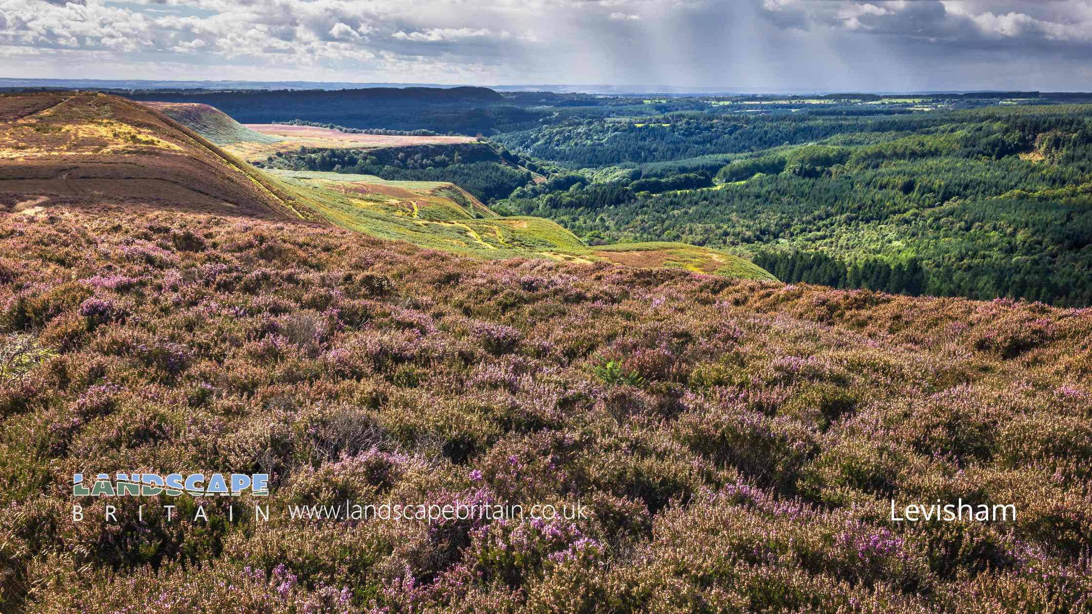
Levisham is a small, picturesque village located in the Ryedale district of North Yorkshire, England. Nestled within the North York Moors National Park, it offers a serene and idyllic rural setting. Known for its charming character and stunning natural beauty, Levisham is a favorite among those seeking a peaceful countryside experience.
The village itself is steeped in history, with roots tracing back to the Domesday Book of 1086. It maintains much of its traditional architecture, with stone cottages and historical buildings that add to its rustic charm. The heart of the village is marked by a quaint village green, surrounded by well-preserved houses and a classic British pub, which serves as a social hub for both locals and visitors.
One of Levisham’s most significant attractions is the Levisham Station, part of the North Yorkshire Moors Railway. This heritage railway line is a popular tourist attraction, offering steam train rides through the scenic moorland. The station, beautifully restored to its original early 20th-century condition, provides a nostalgic journey back in time and is often used as a filming location for period dramas.
The surrounding countryside offers ample opportunities for outdoor activities. Hikers and nature lovers are drawn to the Levisham Moor, an area of outstanding natural beauty with sweeping views of the moors. The area is rich in wildlife, including a variety of bird species, making it a haven for birdwatchers. Additionally, the nearby Hole of Horcum, a massive natural amphitheatre formed by glacial erosion, provides a spectacular landscape for walkers and photographers alike.
Community life in Levisham is vibrant, with local events and traditions still being an essential part of village life. Annual events, local markets, and community gatherings maintain a strong sense of community and tradition. Despite its small size, Levisham’s blend of historical charm, natural beauty, and strong community spirit make it a unique and treasured location within North Yorkshire.
Created: 7 January 2024 Edited: 26 March 2024
Levisham
Local History around Levisham
There are some historic monuments around including:
Field system and cairnfield on Lockton High Moor, 1km NNE of Needle PointPrehistoric field system, medieval rabbit warren and post-medieval mining test pits on Rhumbard SnoutCross ridge dyke known as Gallows Dike and three round barrows 330m south west of Glebe FarmBeacon Hill ringwork siege castle and Royal Observer Corps postPrehistoric dyke known as Horcum DikeRound barrow 600m SSW of Saintoft GrangeRound barrow 500m west of Low DalbyTwo round barrows 800m south of FarfieldsPrehistoric linear boundary on Stonygate Moor, 550m west of Warren House FarmRawcliffe Howe round barrowRound barrow 400m north east of Haugh RiggRound barrow 50m north east of Manor FarmRound barrow 460m north west of the Adder StoneRound barrow 400m north east of Low Pasture FarmRound barrow 780m north of Grove HouseRound barrow 650m north west of St Hilda's Church, EllerburnRound barrow 430m north west of Crossdale HeadCross dyke on Saltergate Brow, 750m south east of Barr FarmRound barrow 140m west of Haugh RiggSix round cairns at Rustif Head, 860m south east of Mount Pleasant FarmRound barrow 160m north of Manor FarmPickering Castle: 11th century motte and bailey castle and 13th century shell keep castleCross dyke centred 480m south of Fox and Rabbit FarmRound barrow 570m south of Saintoft GrangeTwo sections of Roman road on Pickering MoorRabbit type 570m south east of Pexton Moor FarmRound cairn on Pexton Moor, 150m north east of Pexton Moor FarmRound barrow 520m north west of St Hilda's Church, EllerburnStone alignment 350m east of Newgate FootFour round barrows 875m north west of High BlansbyAllerston medieval manorial centre, dovecotes and 17th century gunpowder worksRabbit type on Sneverdale Rigg, 875m north east of Low Dalby HouseRound barrow on Newclose Rigg, 380m south of Adder StoneRound cairn on Skivick Crag, 380m south west of Wheeldale LodgeWarrening enclosure 1.07km east of High Rigg FarmPart of a cross dyke with associated warrening features, 850m south east of High Rigg FarmFour round barrows 320m east of High PasturesRound barrow on Wheeldale Moor, 1150m west of Wheeldale LodgeMauley Cross in Cropton Forest 580m north of Hill Top FarmCross dyke on Far Black Rigg, 1060m north west of Black Dale BridgeTwo round barrows 400m south west of West FarmStanding cross 180m north of Hall FarmRound barrow 395m north west of the Adder StoneRound barrow 440m north of Blansby Park FarmRound barrow 570m south east of Warren HouseExtensive prehistoric and medieval remains on Levisham MoorTwo sections of Roman road on Flamborough RiggHead Road round cairnEast Toft Dike: a cross dyke 720m south and 680m south west of Little Marfit HeadBlack Howe round barrowWarrening enclosure 975m north east of High Paper Mill FarmWarrening enclosure 1.08km north east of High Paper Mill FarmRound barrow on Newclose Rigg, 500m south west of Adder StoneRabbit type on Flainsey Rigg, 1.3km east of Dalby MeadowTwo round barrows on Newclose Rigg, 810m north east of High Rigg FarmMalo Cross, 450m south east of Nab FarmRound barrow 300m north west of Warren HouseTwo prehistoric linear boundaries with associated features, 680m ESE and 880m NNE of Pexton Moor FarmTwo round barrows 60m south east of the Adder StoneRound barrow 280m south west of Haugh RiggPrehistoric linear boundary in Ellerburn Wood, 370m north west of St Hilda's ChurchRound barrow on Wheeldale Moor, 1250m west of Wheeldale LodgeThree medieval pillow mounds 900m north of Grove HouseThree round barrows 130m north west of Seavy PondCairnfield and field systems on Saltergate Moor, immediately north of Nab FarmPrehistoric linear boundary and associated features centred 500m north east of High Bride StonesRound cairn 510m south of Lower FarmSimon Howe: a round cairn on Goathland Moor, two associated round barrows, a standing stone and a stone alignmentRound barrow 200m north west of the Adder StoneWarrening enclosure on Flainsey Rigg, 1.45km east of Upper Dalby WoodRoxby Hill manorial complex and associated ridge and furrow earthworksRound barrow 660m south west of Glebe FarmThree round barrows on Ness Head 750m east of Howlgate FarmTwo round cairns 450m south of Lower FarmRound barrow on Newclose Rigg, 690m south west of Adder StoneRound barrow 400m north of Levisham HallCairnfield on Howl Moor 510m south of Wheeldale Lodge, including an unenclosed hut circle settlement, field system and round burial cairnsWarrening enclosure at Longdale Howl, 400m west of the Adder StoneGoathland Roman road, on Wheeldale MoorPart of a warrening enclosure 470m south east of High Rigg FarmWarrening enclosure on Flainsey Rigg, 1.5km east of Low Dalby.


