Knapdale Forest by munki-boy
Knapdale Forest
Knapdale Forest is located 7 miles to the west of Lochgilphead, in the Heart of Argyll. Situated in a National Scenic Area, it is flanked to the north by the Crinan Canal and to the west by the Sound of Jura and Loch Sween.
The name is derived from the Gaelic description of its striking topographical features; Cnap (hill) and Dall (field).
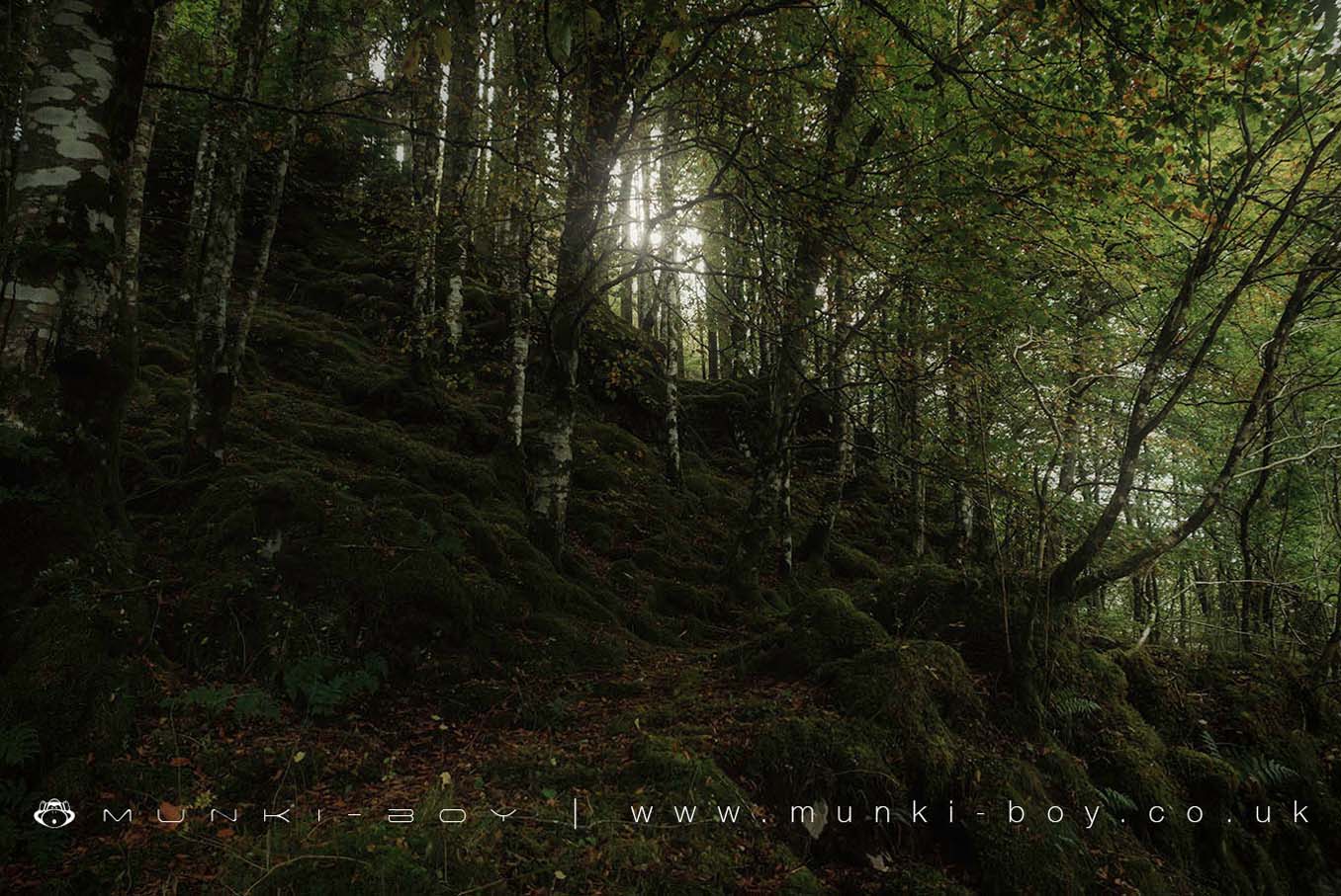
Knapdale Forest is one of the most stunning parts of Scotland and is home to some of the country’s most spectacular wildlife.
This stunning landscape boasts Atlantic woodlands, beautiful coastlines, hills and glens.
Knapdale is home to the Scottish Beaver Trial, a unique partnership project which has reintroduced beavers to the UK for the first time in 400 years on a trial basis.
Beavers also share this landscape with ospreys, red squirrels, otters and golden eagles.
Thousands of years of human occupation can also be seen in the area, including prehistoric forts.
Created: 27 November 2016 Edited: 29 November 2023
Knapdale Forest
Knapdale Forest Woodland
Knapdale Forest is a woodland area in Argyll, managed by Forestry Commission Scotland.Local History around Knapdale Forest
There are some historic monuments around including:
Duntroon, fort 140m N of Duntroon Lodge Prehistoric domestic and defensive: fort (includes hill and promontory fort) SM240Ballymeanoch,kerb cairn 430m NW of Prehistoric ritual and funerary: cairn (type uncertain) SM3749Crinan Harbour, pyroligneous acid works Industrial: chemical SM5814Ardifuir,dun 2400m W of Poltalloch Prehistoric domestic and defensive: dun SM234Castle Dounie, dun, Knapdale Prehistoric domestic and defensive: dun SM10091Poltalloch, three cists 320m S of Cnoc-an-teallaidh Prehistoric ritual and funerary: cist SM225Nether Largie Mid, cairn 305m NNE of Nether Largie Prehistoric ritual and funerary: cairn (type uncertain) SM13298Nether Largie,cup marked rock 440m N of Fork Roads Prehistoric ritual and funerary: cupmarks or cup-and-ring marks and similar rock art SM217Poltalloch, cist 55m WNW of North Lodge Prehistoric ritual and funerary: cist SM221Crinan Canal,Loch a' Bharain canal feeder Industrial: inland water SM6502Ballygowan,prehistoric rock carvings 100m N of Prehistoric ritual and funerary: cupmarks or cup-and-ring marks and similar rock art SM90025Nether Largie North, cairn 480m NNE of Nether Largie Prehistoric ritual and funerary: cairn (type uncertain) SM13294Nether Largie South, chambered cairn 120m S of Nether Largie Prehistoric ritual and funerary: chambered cairn SM13299Arichonan,township Secular: bridge SM5797Dunchragaig,cairn 280m NW of Prehistoric ritual and funerary: cairn (type uncertain) SM90111Loch Coille-Bharr, enclosure 220m NW of, Knapdale Prehistoric domestic and defensive: enclosure (domestic or defensive) SM10336Crinan Canal,Cairnbaan - Ardrishaig Industrial: inland water SM6501Ballymeanoch, henge, 390m WNW of Ballmeanoch Cottage Prehistoric ritual and funerary: henge SM176Achnamara, clapper bridge, Knapdale Industrial: road or trackway SM10341Temple Wood,stone circles and cairns 330m SW of Nether Largie Prehistoric ritual and funerary: cairn (type uncertain) SM90300Ballymeanoch,cairn 300m NW of Prehistoric ritual and funerary: cairn (type uncertain) SM3342Kilmartin Churchyard, crosses, tombstones, & Neil Campbell Tomb Crosses and carved stones: sculptured stone (not ascribed to a more specific type); Ecclesiastical: burial ground, cemetery, graveyard SM13316Barnluasgan, enclosure 950m NNE of Prehistoric domestic and defensive: homestead SM7265Kilmory Oib Township, cross slab and holy well, W of Loch Coille-Bharr Crosses and carved stones: cross slab; Ecclesiastical: well; Secular: settlement, including deserted, depopulated and townships SM270Crinan Canal,Crinan to Cairnbaan Industrial: inland water SM6500Barr a Chuirn,fort 430m ENE of Prehistoric domestic and defensive: fort (includes hill and promontory fort) SM3360Loch Coille-Bharr, crannog, Knapdale Prehistoric domestic and defensive: crannog SM10131Baluachraig,prehistoric rock carvings 100m SW of Prehistoric ritual and funerary: cupmarks or cup-and-ring marks and similar rock art SM90026Ri Cruin,cairn 210m S of Prehistoric ritual and funerary: cairn (type uncertain) SM90247Dun, enclosure and cairn, 200m W of Barnluasgan Prehistoric domestic and defensive: dun; Prehistoric ritual and funerary: cairn (type uncertain) SM10337Poltalloch,cup & ring marked rock 225m N of Prehistoric ritual and funerary: cupmarks or cup-and-ring marks and similar rock art SM222Kilchoan Lodge,chambered cairn Prehistoric ritual and funerary: chambered cairn SM220Barsloisnach, two cists 230m ESE of Prehistoric ritual and funerary: cist SM181Ballymeanoch, standing stones 450m NW of Prehistoric ritual and funerary: stone setting SM4301Poltalloch,cup & ring marked rock SW of Prehistoric ritual and funerary: cupmarks or cup-and-ring marks and similar rock art SM223Druim an Duin,dun Prehistoric domestic and defensive: dun SM2420Dunadd, standing stone 190m ESE of Dunadd Cottage Prehistoric ritual and funerary: standing stone SM197Rowanfield Cottage,cist 275m SW of Prehistoric ritual and funerary: cist SM228Rubha Cladh Eoin, fort, Knapdale Prehistoric domestic and defensive: fort (includes hill and promontory fort) SM10343Gartnagreanoch, chambered cairn, Knapdale Prehistoric ritual and funerary: chambered cairn SM10342Loch Coille-Bharr, mill and lade, Knapdale Industrial: farming, food production SM10335Dunadd,fort,boar carving,ogam inscription and cupmarkings Crosses and carved stones sculptured stone; Prehistoric domestic and defensive hill and promontory fort; Prehistoric ritual and funerary cupmarks or cup-and-ring marks SM90108Poltalloch,standing stone 500m WSW of East Lodge Prehistoric ritual and funerary: standing stone SM224Rhudil Mill,cairn 225m NW of Prehistoric ritual and funerary: cairn (type uncertain) SM226Achadh na Cille, burial ground 450m NW of Rubha nan Sgarbh Crosses and carved stones: cross-incised stone; Ecclesiastical: burial ground, cemetery, graveyard SM10334Barnluasgan, enclosures 1200m NNE of Prehistoric domestic and defensive: enclosure (domestic or defensive) SM3860Lady's Seat,cairn 420m WNW of Ballygowan Prehistoric ritual and funerary: cairn (type uncertain) SM211Crinan Moss,cist,Barsloisnoch Prehistoric ritual and funerary: cupmarks or cup-and-ring marks and similar rock art SM195Nether Largie,standing stones 400m S of Fork Roads Prehistoric ritual and funerary: standing stone SM218Barnluasgan, enclosure 530m NNE of Prehistoric domestic and defensive: homestead SM3861.