Kingston Russell Stone Circle by Blackbeck from Getty Images Signature
Kingston Russell Stone Circle
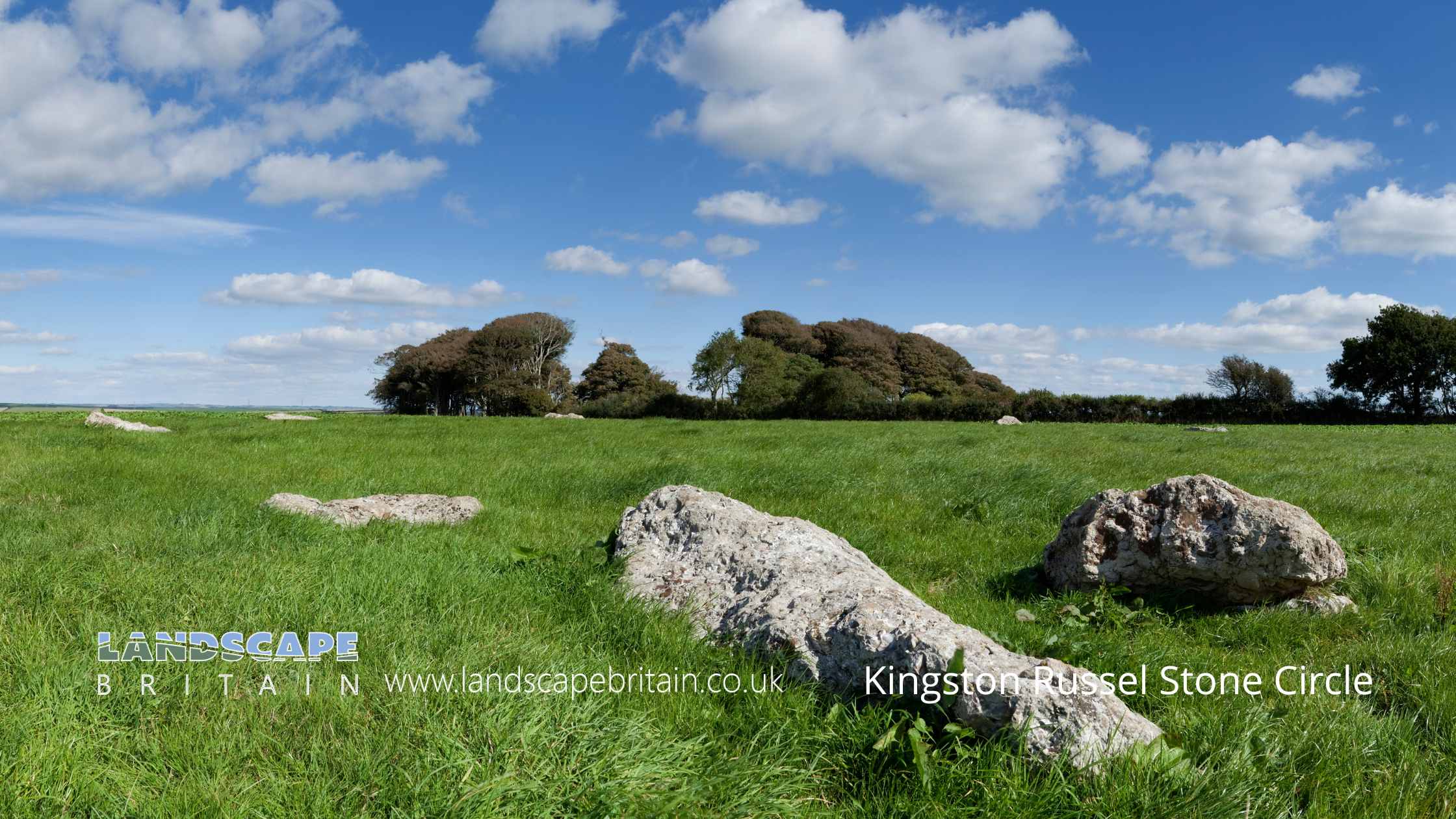
The Kingston Russell Stone Circle is a significant prehistoric monument located on a chalk ridge that offers a commanding view of the surrounding downland. This ancient site, notable for its irregular yet almost circular layout, has a maximum diameter of 30 meters and currently features 18 visible stones. The circle’s interior rests on level ground, enhancing its striking appearance against the natural backdrop. The stones themselves, composed of sarsen or conglomerate, are all now recumbent, indicating they have fallen from their original upright positions over time. These stones vary in size, with some measuring up to 2 meters by 0.5 meters, while others are smaller, around 1 meter by 0.3 meters. The partial burial of these stones suggests that their true size may be greater than what is presently visible, hinting at their original impressive stature.
The historical importance of the Kingston Russell Stone Circle is underscored by records that mention two additional stones located outside the main circle. However, the authenticity of their original placement remains uncertain, adding an element of mystery to the site’s layout and history. The circle’s construction and the materials used offer valuable insights into the practices and capabilities of the people who erected it. The use of sarsen and conglomerate, both robust and enduring materials, highlights the significance attributed to this monument by its builders.
Despite the passage of time and the natural wear and tear that has left all the stones in a recumbent state, the Kingston Russell Stone Circle continues to captivate historians, archaeologists, and visitors alike. Its position on a chalk ridge not only provides a picturesque setting but also implies a deliberate choice by its creators, possibly for ceremonial or astronomical purposes. The monument’s partial burial and the varying sizes of the stones contribute to ongoing research and debates regarding the circle’s original appearance and function.
The site is carefully managed to preserve its historical integrity. While the stones themselves are protected, modern additions such as the information notice board on the south-eastern side are excluded from the official scheduling, although the underlying ground remains included. This approach ensures that visitors can learn about the site without compromising its preservation. The Kingston Russell Stone Circle stands as a testament to the ingenuity and cultural significance of its prehistoric creators, continuing to inspire awe and curiosity in all who encounter it.
Created: 26 May 2024 Edited: 17 September 2024
Kingston Russell Stone Circle
Kingston Russell Stone Circle LiDAR Map

Contains public sector information licensed under the Open Government Licence v3.0
Local History around Kingston Russell Stone Circle
There are some historic monuments around including:
Bowl barrow 645m south west of North Barn FarmBowl barrow on Limekiln Hill 500m north of Labour-in-Vain FarmBowl barrow 600m west of Well Bottom Wood, forming part of the Pitcombe Down round barrow cemeteryRound barrow NW of Long Bottom PlantationBronze Age enclosure, associated linear earthworks and field system, and a later dewpond on Tenants HillBowl barrow 550m north east of Pitcombe Farm, part of the Black Down round barrow cemeteryAbbotsbury Castle (camp)Barrow beside Shotcombe LaneTwo long barrows and round barrows on Long Barrow HillRound barrow in White Hill PlantationBowl barrow and disc barrow 730m south of Kingston Russell Farm, forming part of the round barrow cemetery on the south western part of Black DownOld Warren earthworkFour bowl barrows 500m west of Well Bottom Wood, forming part of the Pitcombe Down round barrow cemeteryRound barrow E of The BuildingsBowl barrow 220m NNW of Topparts DairyBowl barrow 680m north east of Whatcombe House, forming part of the round barrow cemetery on the south western part of Black DownTwo round barrows on Wears HillLong barrow E of Northfield PlantationTwo bell barrows 15m north of Well Bottom Wood, part of the Poor Lot round barrow cemeteryGroup of three round barrows on Eggardon HillChambered tomb called The Grey Mare and her ColtsBowl barrow 400m north east of Look FarmBowl barrow 500m west of Well Bottom Wood, forming part of the Pitcombe Down round barrow cemeteryBowl barrow on Black Down, 150m north west of the Hardy MonumentCross dyke 600m north of Pitcombe FarmBowl barrow 800m south of Kingston Russell Farm, forming part of the round barrow cemetery on the south western part of Black DownDisc barrow 200m north east of Winterbourne Poor Lot, forming part of the Poor Lot round barrow cemeteryTwo bowl barrows on Black Down immediately east of the Hardy MonumentTwo bowl barrows 1250m east of Notton Hill BarnThree bowl barrows 300m south west of Well Bottom Wood, forming part of the Pitcombe Down round barrow cemeteryLime kiln 800ft (245m) NW of Langton CrossPart of a Later Iron Age or Romano-British settlement 590m north west of Compton BarnBowl barrow and disc barrow 900m south east of Kingston Russell Farm, part of the Black Down round barrow cemeteryDyke on Wears HillThree round barrows E of Smitten CornerBowl barrow 140m south east of Broadwater CottageTwo fishponds in Oddens WoodBowl barrow 620m south west of Eggardon Hill FarmChambered tomb 900m south west of Manor FarmSt Peter's AbbeyLynchets S of Stavordale WoodThe Nine Stones: a small concentric stone circle 750m west of Winterbourne AbbasBowl barrow in New Planting, forming part of the Three Barrow Clump round barrow cemeteryBowl barrow 700m east of South Eggardon FarmBowl barrow on Limekiln Hill 650m south east of Green LeazeEnclosure on Sheep Down 930m south east of Heart ClumpDyke SE of Eggardon Hill campBowl barrow on Black Down, 50m south of the Hardy MonumentLong mound and three bowl barrows forming part of a round barrow cemetery 760m NNE of Whatcombe House on the south western part of Black DownThree bowl barrows at Dry Wood, forming part of the Longlands round barrow cemeteryStanding stone called The Broad StoneBowl barrow on Black Down, 870m north west of the Hardy MonumentTriple barrow and bowl barrow forming part of a barrow cemetery and part of an associated field system 250m north east of Winterbourne Poor LotGroup of three round barrows W of Two GatesGroup of three round barrows SW of Longlands BarnLarge multivallate hillfort containing two bowl barrows 855m north east of North Eggardon FarmRound barrow E of Two GatesHelstone burial chamberHampton stone circleBowl barrow on Sheep Down, 600m east of Home Farm CottagesTwo round barrows at crossroads N of villageBowl barrow 450m NNE of West Hill FarmBowl barrow and pond barrow within Well Bottom Wood, part of the Winterbourne Poor Lot round barrow cemeteryThe Kingston Russell stone circle 750m north east of Gorwell FarmBell barrow 100m south of Winterbourne Poor Lot, part of the Winterbourne Poor Lot round barrow cemeteryRound barrow SW of Pigeon House CottagesBowl barrow 350m NNW of Topparts DairyLangton Cross: a wayside cross 850m south west of Tatton HouseFour bowl barrows 725m ESE of Wears FarmBowl barrow 770m north of Whatcombe House, forming part of the round barrow cemetery on the south western part of Black DownEarthworks on Askerswell DownBowl barrow 360m south of Compton BarnLong barrow W of Hampton BarnGroup of barrows near Big WoodSettlement E of Brow CopseBowl barrow 800m north east of Gorwell FarmBowl barrow on Black Down, 400m north west of the Hardy MonumentRound barrow SW of villagePenannular ditched enclosure, 150m south of Turner's Farm BarnBowl barrow 165m NNW of White Hill Barn, forming part of the White Hill round barrow cemeteryBowl barrow 850m north west of Whitefriars Broiler HousesBowl barrow 550m WNW of Dowerfield HouseBowl barrow 300m WNW of White Hill Barn, forming part of the White Hill round barrow cemeteryBowl barrow 300m west of New Planting, forming part of the Three Barrow Clump round barrow cemeteryBowl barrow 605m south west of Long Barrow FarmBowl barrow 750m SSE of Lower Kingston Russell FarmEggardon Hill disc barrowBowl barrow in Well Bottom WoodStanding stone 700m south east of North Barn FarmBowl Barrow, 710m south-west of Woolcombe FarmBowl barrow on Black Down, 770m north west of the Hardy MonumentLong barrow 200m north west of Longlands FarmBell barrow and five bowl barrows 1000m south east of Kingston Russell Farm, part of the Black Down round barrow cemeteryThree barrows near Town Hill BarnBowl barrow 600m west of Well Bottom Wood, forming part of the Pitcombe Down round barrow cemeteryDyke on Haydon DownRound barrow on Pound HillPart of a Later Prehistoric or Romano-British field system 250m north of Eggardon Hill FarmTwo conjoined bowl barrows 550m north east of Manor FarmRound barrows on Sheep DownDyke on Long Barrow HillBowl barrow 400m north east of Manor Farm, part of the Pound Hill round barrow cemeteryRound barrow 250yds (230m) S of Chapel CoppiceRound barrows N of Pound HillBowl barrow 265m north west of White Hill Barn, forming part of the White Hill round barrow cemeteryThree bowl barrows on The Knoll 450m north west of TreetopsLong barrow NE of AshleyBowl barrow 450m north east of Manor Farm, part of the Pound Hill round barrow cemeteryBarrow 650yds (600m) N of North Barn FarmGroup of five round barrows on White HillTwo bowl barrows 700m south east of Kingston Russell Farm, part of the Black Down round barrow cemeteryDisc barrow 500m south east of Winterbourne Poor LotBell barrow 125m west of Longlands Farm, forming part of the Longlands round barrow cemeteryBowl barrow 800m NNE of Whatcombe House, forming part of the round barrow cemetery on the south western part of Black DownTwenty-one barrows forming part of a round barrow cemetery at Winterbourne Poor LotFour round barrows NW of Blagdon BarnBowl barrow 810m NNE of Whatcombe House, forming part of the round barrow cemetery on the south western part of Black DownRound barrows W of Blagdon BarnBowl barrow 355m north west of White Hill Barn, forming part of the White Hill round barrow cemeterySix round barrows 200m west of New Planting, forming part of the Three Barrow Clump round barrow cemeteryLong mound 860m NNE of Whatcombe House, associated with the round barrow cemetery on the south western part of Black DownBowl barrow180m east of Hogleaze BungalowBowl barrow 500m NNW of Topparts DairyBowl barrow on Black Down, 450m north west of the Hardy MonumentBarrow 300yds (280m) SW of Kingston FarmBowl barrow 340m north west of White Hill Barn, forming part of the White Hill round barrow cemeteryChambered long barrow N of Loscombe PlantationCamp on Chilcombe HillEarthwork 80yds (70m) long NW of Coombe BottomBowl barrow 120m east of White Hill WoodBowl barrow 320m north west of Coombefield FarmBowl barrow on Black Down, 80m south east of the Hardy MonumentField system in Valley of Stones (including earthwork N of Crow Hill)Duck decoy at Abbotsbury Swannery, 630m SSW of Horsepool FarmBell barrow 850m south east of Kingston Russell Farm, part of the Black Down round barrow cemeterySt Catherine's Chapel, field system and quarries at Chapel HillBowl barrow 450m NNW of Field BarnBowl barrow 700m NNW of Whitefriars Broiler HousesFrampton Roman villaBowl barrow 200m south of Winterbourne Poor Lot forming part of the Winterbourne Poor Lot round barrow cemeteryThree bowl barrows on Tulk's Hill 800m north of East Bexington FarmRound barrow 230yds (210m) E of White Hill PlantationTwo bowl barrows 283m SSE of the Grey Mare and her ColtsBowl barrow and pond barrow 880m south east of Kingston Russell Farm, part of the Black Down barrow cemeteryTwo bowl barrows 400m west of Longlands Farm, forming part of the Longlands round barrow cemetery.


