Ilkley Manor House by Dave Porter
Ilkley Manor House
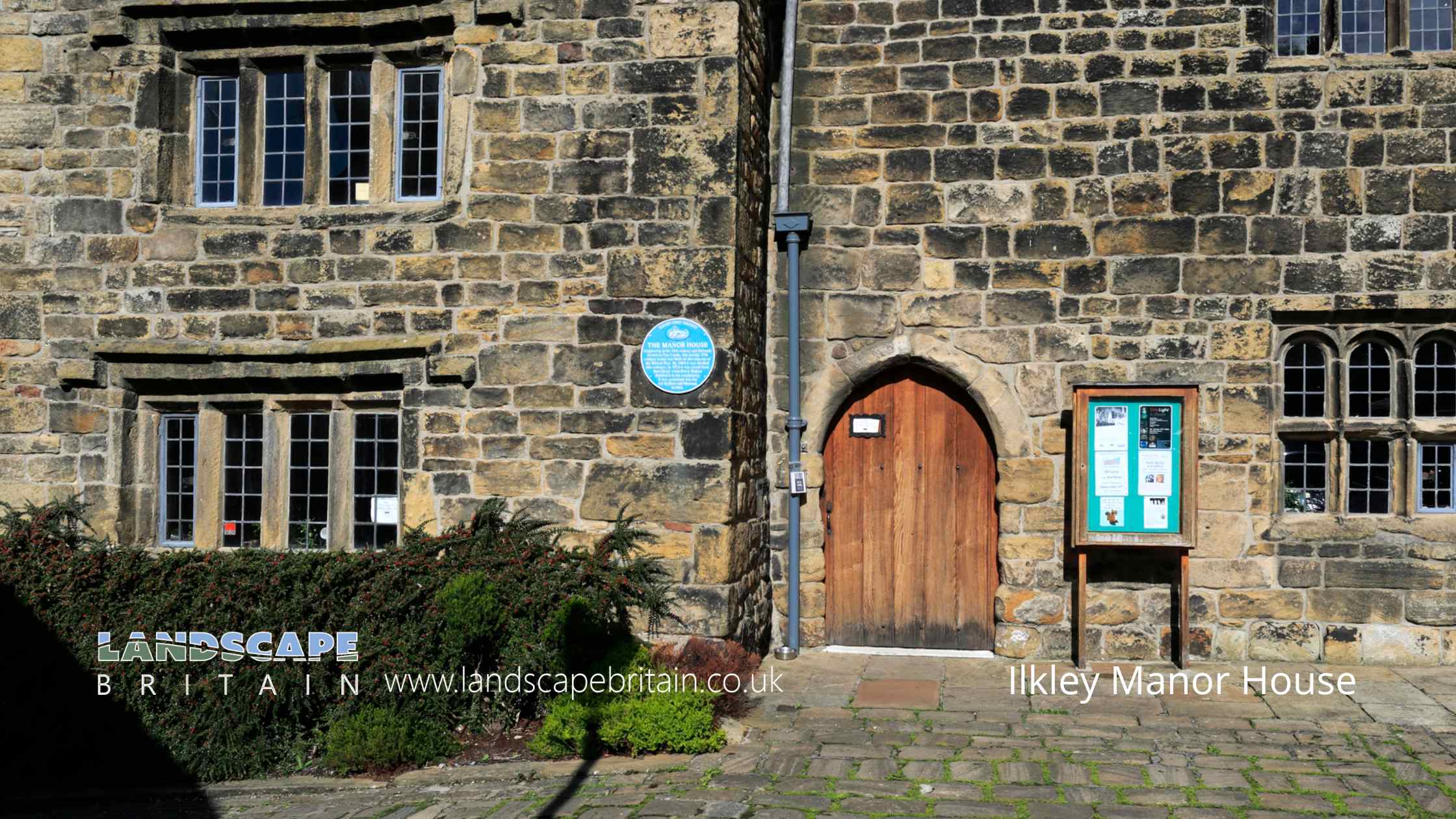
The Grade I listed Ilkley Manor House, is a remarkable historical building that stands as a testament to the architectural and cultural heritage of the region. This large house, now serving as a museum, dates back to the 16th century, with its central portion potentially originating from an even earlier period. The structure’s irregular composition and varied storey heights, ranging from two to three floors, contribute to its distinctive character and historical ambiance.
Constructed from coursed, squared stone and topped with a stone slab roof, Ilkley Manor House features two primary ranges extending to the east and west. The main north facade is particularly notable for its array of gabled projections and diverse window designs. The left end of the north front boasts a gabled projection, while the right end displays two abutting gables. The fenestration includes an assortment of 4-light, 3-light, and 5-light windows, most of which are adorned with dripmoulds. Notably, the third storey window in the left gable features three lights under a dripmould, a unique characteristic of this gable only. The round-headed lights, a hallmark of the period, dominate the majority of the windows, except for those in the left gable and the upper central portion.
The house’s entrances are equally diverse, with a plain pointed doorway situated to the left of the central portion, complemented by later additions of straight-headed doorways at the right of the centre and the left of the right-hand gable. These variations in design and style reflect the building’s long history and the various modifications it has undergone over the centuries. The right-hand gables are further embellished with crocketed finials, adding a touch of gothic elegance to the overall aesthetic.
At the rear of the manor house, an additional fourth gable enhances the architectural complexity of the structure. This blend of historical elements and stylistic features makes Ilkley Manor House not only a significant cultural landmark but also a fascinating subject for study and appreciation. As a museum, it offers visitors a unique glimpse into the past, preserving the architectural beauty and historical narrative of Ilkley for future generations.
Created: 17 June 2024 Edited: 17 September 2024
Ilkley Manor House
Local History around Ilkley Manor House
There are some historic monuments around including:
Carved rock known as the Badger StoneCup marked rock and cairn near path 775m ESE of Blackhill House, Middleton MoorThree carved rocks opposite St Margaret's ChurchCup and groove marked rock near grouse butts on Foldshaw Ridge 905m ESE of Wards End, Middleton MoorRock with many cup marks on ridge between Dryas Dike and Delves Beck 880m ESE of Blackhill House, Middleton MoorCup and ring marked rock known as Langbar Rock 750m ENE of Wards End, Langbar MoorRock with one large cup mark on the south slope of High Black Hill, 330m east of the shooting shelter in Middleton Moor EnclosureCup and groove-marked rock on east edge of Glovershaw quarryFlat carved rock 150m south west of Silver Well CottageSmall cup-marked rock 30m east of Glovershaw quarryCup and groove marked rock north of Birch Close Farm house, High EldwickCarved rock in the wall at north edge of Otley Road north west of the Fleece InnCup and ring marked rock next to wall NNW of Black PotsCup-marked rock in stone quarry on Stocks HillRing cairn 90m ESE of the Great Skirtful of StonesRound barrow and L-shaped earthwork on Baildon Golf CourseLarge cup and ring marked rock in forestry furrows on RivockRock with two deep cup marks north of track along Foldshaw Ridge, 460m south west of the shooting shelter, Middleton MoorRecumbent gatepost with cup and ring carving 57m west of the Swastika StoneRock with five cups near Haystack RockCairnfield with linear banks and carved rocks stretching from Woofa Bank to Green CragCup marked rock in field south of Stead Hall FarmCarved rock and associated prehistoric walling above Backstone Beck, 200 WNW of Gill Head ReservoirRock with parallel grooves 95m west of flag post on Craven Hall HillRock with cup marks in south east face near grouse butts on Foldshaw Ridge 860m ESE of Wards End, Middleton MoorEnclosure on Woofa Bank with 11 carved rocks and one upright stoneCup marked rock in forestry furrow on RivockSmall rock with four cup marks and a large hewn rock with one cupmark on Foldshaw Ridge 830m ESE of Wards End, Middleton MoorSection of rubble walling east of Grammar School Cairn, on Cranshaw Thorn HillGrubstones stone circleRock with two large cup marks on slope west of enclosure on Woofa BankCup and ring marked rock 42m east of Rivock Edge triangulation pillarCarved rock between Backstone Beck and the path to Gillhead 365m south west of Gill Head ReservoirWesternmost of two carved rocks under Green Crag west of gas pipelineTwelve Apostles stone circle, Burley MoorLarge carved rock at hill top, north east of line of stone grouse butts on RivockThree carved rocks on Long Ridge 420m south east of Wards End, Middleton MoorCup marked rock between Doubler Stones and Gawk StonesCup marked rock on low knoll west of and overlooking Cow and Calf HotelCup and groove marked rock 32m south west of wall near Stead CragCarved rock in strip of trees on north side of track from Stead to Burley in WharfedaleGrooved rock on slope at LanshawBolton PrioryCup and groove marked rock on south slope of High Black Hill, 750m north of March Ghyll Reservoir, Middleton Moor EnclosureTwo cup marked rocks between Dryas Dike and Delves Beck 810m ESE of Blackhill House, Middleton MoorEnclosure, fieldwalls and cairnfield, including seven carved rocks and an upright stone.Cup and groove-marked rock north of Drake HillCup, ring and groove marked rock near ford across Whinthorn Ridge Gill in Middleton Moor Enclosure, 430m NNE of March Ghyll ReservoirCup marked rock east of entrance to Silver Well CottageRock with four cup marks near relict walling north of Dryas Dike 710m ESE of Wards End, Middleton MoorCup and ring marked rock north of Pennythorn HillLarge carved boulder on eminence between two streams east of Barmishaw WellCup and groove-marked rock on Rivock, west of a deep channelCup and Ring marked rock known as the Hanging Stone RockCup-marked rock on slight bank north east of Glovershaw quarryCarved rock with rounded triangular profile 48m NNW of enclosure on Woofa BankCarved rock next to the drive of Overdale Nursing HomeCup and groove marked rock between East Morton and West MortonTwo cup and ring marked rocks in conifer plantation on RivockCup and ring marked rock 350m SSW of Panorama ReservoirAnglo-Saxon cemetery and medieval manorial centre including fishponds and part of the open field system adjacent to St Peter's ChurchGatepost with cup marks and grooves 350m SSE of West Moor House, at side of road 500m west of Bow BeckGrooved rock and cup and ring marked rock 420m east of Badger StoneCup marked rock on slope, 480m ENE of the shooting shelter in Middleton Moor EnclosureCup marked rock 14m from the wall on the unforested plateau at RivockCarved rock known as the Swastika StonePartially quarried cup and groove marked rock between track and wall at east end of Foldshaw Ridge, 470m south of the shooting shelter, Middleton MoorCup marked rock lying 200m south of and above White WellsCarved rock east of track north of Drake HillCarved rock incorporated in and extending beyond outbuilding at Hardwick House FarmCup and groove marked rock on flat ground south of Foldshaw Ridge, 510m SSW of the shooting shelter, Middleton MoorRock with two cup marks south east of quarry at Cow and Calf RocksCup and groove marked rock in garden of Oakwood Barn, High EldwickCup and ring marked rock east of Eaves Crag, Baildon MoorRound cairn on east flank of Baildon HillTwo cairns on Hawksworth Moor, one with an internal cistCarved rock on bank of How Beck, east of path from West Morton to Riddlesden and 440m south west of Barn House FarmCup and ring marked rock 340m east of Badger StoneRock with at least four large cups and a groove north of Dryas Dike 800m ESE of Wards End, Middleton MoorRound cairn and curving bank on Pennythorn HillRock in Panorama Woods with single cup and ring carvingCairn known as the Little Skirtful of StonesCairn on Hawksworth Moor; largest one of a group of cairnsRock with many cup marks and one groove between Dryas Dike and Delves Beck 910m ESE of Blackhill House, Middleton MoorSmall cup-marked rock on Stanbury Hill, 40m west of fork in pathTwo fragments of carved bedrock east of Crocodile Rock, near west end of Hangingstones QuarryProminent rock with one cup mark at apex on ridge between Dryas Dike and Delves Beck 830m ESE of Blackhill House, Middleton MoorRock with at least eight cups and two long grooves on ridge between Dryas Dike and Delves Beck 870m ESE of Blackhill House, Middleton MoorCarved rock near north east corner of Glovershaw quarryCarved rock in a valley on south side of Cranshaw Thorn Hill 460m WSW of Gill Head ReservoirCup marked rock with triangular groove 75m east of enclosure on Woofa BankSmall cairn and carved rock on ridge at Lanshaw overlooking Woofa BankCup and ring marked rock at Lanshaw; 1km WSW of High Cragg FarmCup, ring and groove marked rock west of the path between Black Hill and Loftshaw Gill, 300m NNE of the shooting shelter in Middleton Moor EnclosureCarved rock 70m south west of Gill Head ReservoirCairn and carved rock on High Black Hill, 410m ENE of the shooting shelter in Middleton Moor EnclosureCup and ring marked rock 300m NNW of Gill Head ReservoirCarved rock in Hawksworth SpringGroup of four carved rocks in Panorama WoodsCup and ring marked rock 370m SSW of Panorama ReservoirCairnfield, carved rocks and associated curved bank at north west end of Green Crag Slack, east of Gill Head ReservoirNorthernmost of two cairns east of Glovershaw quarry, including adjacent cup-marked rockCarved rock in wall of grounds of Overdale Nursing HomeCarved rock 100m north east of eastern Grainings Head QuarryRock with cup marks and long groove 750m ESE of Blackhill House, Middleton MoorThree carved rocks near grouse butts on Foldshaw Ridge 870m ESE of Wards End, Middleton MoorCup and ring marked rock overlooking bend in Ilkley-Keighley road, 185m south east of Neb StoneLarge rock with single cup mark at point where path through Green Crag Enclosure reaches top of slopeCup marked rock north of track at east end of Foldshaw Ridge, 470m SSE of the shooting shelter in Middleton Moor EnclosureCup marked rock in enclosed pasture NNE of Black PotsCarved rock at east end of disused rifle rangeCarved rock known as Pepperpot Rock and adjacent small carved rock west of West Rock and 215m south of White WellsCup and ring marked rock at Lanshaw; easternmost of Lanshaw groupCup, ring and groove marked rock at the base of a wall between East Morton and West MortonEnclosure 50m north east of Horncliff Slade on Hawksworth MoorCup and ring marked rock known as Piper Crag StoneCup and ring marked rock known as the Sepulchre Stone, Addingham MoorsideCup and ring marked rock on moor east of Gawk StonesCairn known as the Great Skirtful of StonesCarved rock on Cranshaw Thorn Hill above Ilkley Crags, 465m west of Gill Head ReservoirCup and ring marked rock at Faweather Farm, High EldwickRock with cup marks 33m north east of Green Crag EnclosureCup, ring and groove marked rock at east end of the low ridge between Dryas Dike and Delves Beck 980m ESE of Wards End, Middleton MoorRock with single cup near track north of Drake HillLarge carved rock in the wall between grouse moor and forestry plantation on RivockCairn at Rombalds Moor triangulation pillarEnclosed settlement containing three carved rocks known as Backstone Beck EnclosureRing cairn 475m south east of the Great Skirtful of StonesProminent cup-marked rock east of track, north east of Stanbury HillProminent cup and ring marked rock on Coarse Stone EdgeLarge rock with cup marks and cup and ring on Foldshaw Ridge 810m ESE of Wards End, Middleton MoorCup marked rock near wall below Rivock EdgeSite of Roman Fort, Ilkley.Striated cup marked rock 20m west of enclosure on Woofa BankCup and groove marked rock on slope south of Delves Beck 870m east of Moor End Farm, Middleton MoorSmall cairn north east of large cairn on Hawksworth MoorTwo cup marked rocks in path south east of quarry at Cow and Calf RocksRock with one cup mark in track at east end of Foldshaw Ridge, 480m SSE of the shooting shelter in Middleton Moor EnclosureCup marked rock on slope south of Green Crag EnclosureCarved rock known as the Barmishaw StoneRock with a complex design of small cup marks and shallow grooves south of Foldshaw Ridge, 440m south of the shooting shelter, Middleton MoorCairnfield including ring cairn and carved rocks on Low Plain, Baildon MoorOld BridgeCairn west of Craven Hall HillRock with one cup mark 860m ENE of Wards End, Langbar MoorCarved rock on Cranshaw Thorn Hill above Ilkley Crags, 560m west of Gill Head ReservoirEnclosures, small cairnfield and carved rocks on Pancake RidgeCup marked rock 1m from wall on unforested plateau at RivockCup marked rock 19m above forestry track in Rivock conifer plantationSplit and hewn cup-marked rock north of a wall junction on RivockRock with seven cup marks enclosed by a groove south of Foldshaw Ridge, 490m south of shooting shelter, Middleton MoorTwo carved rocks on northern slope of ridge at Lanshaw overlooking Woofa BankRock with single cup near wall at Stead CragCup and groove marked rock, 310m north east of the shooting shelter in Middleton Moor EnclosureRock with three cupmarks west of West Rock and 225m south of White WellsRock with seven to eight cup marks north of Dryas Dike 720m ESE of Wards End, Middleton MoorLow rock with one cup on unforested plateau at RivockCairn on west flank of High Black Hill, 210m ENE of the shooting shelter in Middleton Moor EnclosureCup and ring marked rock below Addingham CragTwo adjacent carved rocks and associated rubble bank at top of ridge at Lanshaw overlooking Woofa BankCarved rock known as the Anvil RockCup and ring marked rock 10m south of West RockChurchyard cross at the Church of St PeterCup marked rock 200m west of Cow and Calf HotelRock with cup marks and short groove 740m ESE of Blackhill House, Middleton MoorCarved rock with multiple rings in path above the Cow and Calf Hotel, 180m west of Highfield HouseMedieval settlement and part of the open field system immediately south of Myddleton LodgeCarved rock known as Planets Rock 180m north east of the Gill Head ReservoirBoulder with prehistoric rock art at Glovershaw FarmCarved rock south east of entrance to Silver Well CottageCup marked rock 47m south east of Rivock Edge triangulation pillarCup and grooved marked rock in tree line between New Close Quarry and Poppling Well Beck, 280m south west of Whitbeck ManorLarge cup marked rock west of Green Crag EnclosureLarge flat rock with single cup mark 20m north west of enclosure on Woofa BankRock with dense concentration of cup marks on Stanbury HillRock with single cup mark between road and Pennythorn HillRock with single cup mark in forestry SSE of Black PotsCup and ring marked rock 12.5m from drainage cut NNE of Black PotsCup and ring marked rock between Keighley Gate and Silver Well CottageGroup of five carved rocks on the western ridge of Stanbury HillFive carved rocks near the edge of Rivock outcropCarved rock 110m north east of Badger StoneRock with three cup marks 150m south west of Black Beck HoleRock with shallow cup and ring-markings at the western end of the ridge on Stanbury HillEnclosure with carved rocks and disturbed cairn known as Green Crag EnclosureCup, ring and groove marked rock on south slope of High Black Hill, 350m east of the shooting shelter in Middleton Moor EnclosureTwo carved rocks near Neb StoneCup marked rock and small cairn between Dryas Dike and Foldshaw Ridge 730m ESE of Wards End, Middleton MoorCup and groove marked rock east of New Close Quarry, 300m south west of Whitbeck ManorCup and ring marked rock 90m WSW of Gill Head ReservoirRound Hill, round barrow 1/2 mile (800m) NNE of Upper Austby FarmCup marked rock 230m south of and above White WellsSmall cup marked rock at eastern edge of a hollow 125m south east of the enclosure on Woofa BankSmall carved rock in path east of Glovershaw quarryCarved rock near wall in pasture below Addingham Crag 290m south of Cragg HouseCarved rock 80m east of Green Crag EnclosureCup and ring-marked rock north east of a wall junction on the southern flank of RivockCup marked rock just within afforested area north east of wall on RivockCarved rock 80m NNE of Badger StoneTwo carved rocks, one dome-shaped and one ridged, near grouse butts on Foldshaw Ridge 880m ESE of Wards End, Middleton MoorCup marked rock 39m south east of entrance to Silver Well CottageCup marked rock adjacent to wall near road from East Morton to West MortonCup and ring marked rock between track and grouse butt north of Dryas Dike, 620m south of the shooting shelter, Middleton MoorCarved rock and two cairns 180m ESE of the shooting shelter, Middleton Moor EnclosureCup and ring marked rock between Spicey Gill and the Ilkley-Keighley roadFive carved rocks grouped between Dryas Dike and Delves Beck 840m ESE of Blackhill House, Middleton MoorLarge rock with single cup mark 130m south east of and overlooking Green Crag EnclosureTwo prominent cup marked rock outcrops known as Doubler StonesCairnfield with rubble banks and carved rocks above Stead CragTwo cup marked rocks 220m west of Highfield House.


