
Ilkley
Ilkley
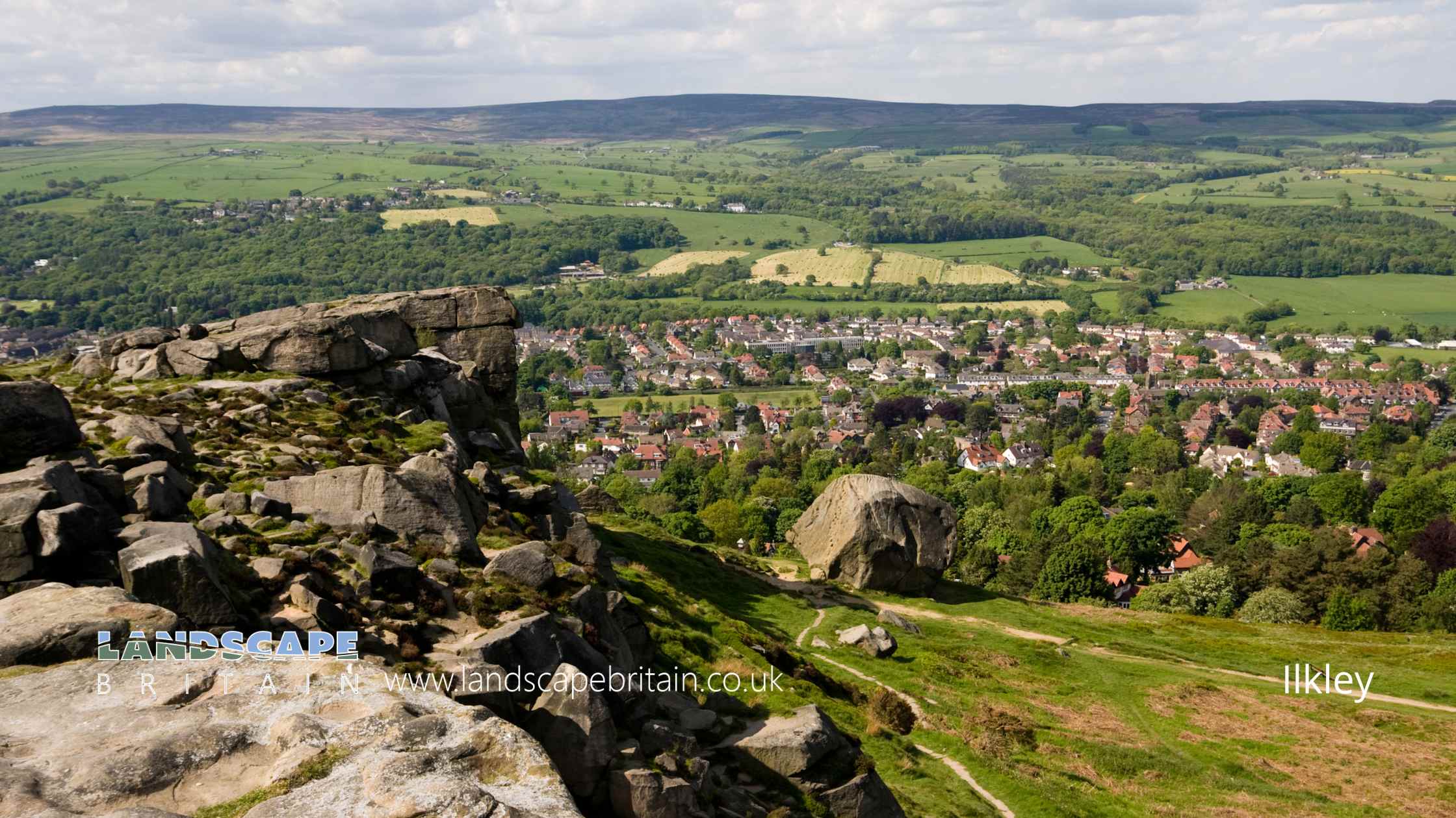
Ilkley is a charming town in Yorkshire, England that is well worth a visit.
The town is located on the River Wharfe and is surrounded by beautiful countryside. There are plenty of things to do in Ilkley, including walking and cycling along the river, visiting the many shops and restaurants, or exploring the nearby moors.
Ilkley Moor is a large expanse of moorland located near the town of Ilkley in Yorkshire, England
The moor is a popular destination for walkers and cyclists, and offers stunning views of the surrounding countryside.
There are also several ancient monuments located on the moor, including the Twelve Apostles stone circle and the Cow and Calf rocks.
Created: 3 December 2022 Edited: 29 November 2023
Ilkley
Shopping in Ilkley
Co-op Food Bolton Bridge Road, Ilkley
Co-op Food supermarket
Co-op Food 22, Brook Street
Co-op Food supermarket
Tesco 19, Springs Lane
Tesco supermarket
Booths Leeds Road, Ilkley
Booths supermarket
Local History around Ilkley
There are some historic monuments around including:
Three carved rocks opposite St Margaret's ChurchCup marked rock on low knoll west of and overlooking Cow and Calf HotelCup and ring marked rock below Addingham CragCarved rock known as the Badger StoneRock with seven cup marks enclosed by a groove south of Foldshaw Ridge, 490m south of shooting shelter, Middleton MoorRock with at least eight cups and two long grooves on ridge between Dryas Dike and Delves Beck 870m ESE of Blackhill House, Middleton MoorOld BridgeCarved rock in strip of trees on north side of track from Stead to Burley in WharfedaleRock with one large cup mark on the south slope of High Black Hill, 330m east of the shooting shelter in Middleton Moor EnclosureCarved rock known as Planets Rock 180m north east of the Gill Head ReservoirCairn on Hawksworth Moor; largest one of a group of cairnsCup marked rock in field south of Stead Hall FarmFive carved rocks grouped between Dryas Dike and Delves Beck 840m ESE of Blackhill House, Middleton MoorCup marked rock in enclosed pasture NNE of Black PotsRock with many cup marks and one groove between Dryas Dike and Delves Beck 910m ESE of Blackhill House, Middleton MoorGrubstones stone circleCup and groove-marked rock north of Drake HillSmall cairn north east of large cairn on Hawksworth MoorCarved rock incorporated in and extending beyond outbuilding at Hardwick House FarmCairn on west flank of High Black Hill, 210m ENE of the shooting shelter in Middleton Moor EnclosureCup-marked rock on slight bank north east of Glovershaw quarryCup and ring marked rock overlooking bend in Ilkley-Keighley road, 185m south east of Neb StoneTwo adjacent carved rocks and associated rubble bank at top of ridge at Lanshaw overlooking Woofa BankGroup of four carved rocks in Panorama WoodsCup marked rock 1m from wall on unforested plateau at RivockCup and groove marked rock 32m south west of wall near Stead CragTwo fragments of carved bedrock east of Crocodile Rock, near west end of Hangingstones QuarryCup marked rock 200m west of Cow and Calf HotelEnclosures, small cairnfield and carved rocks on Pancake RidgeRock with one cup mark 860m ENE of Wards End, Langbar MoorCup and groove marked rock on flat ground south of Foldshaw Ridge, 510m SSW of the shooting shelter, Middleton MoorCup and ring marked rock between Keighley Gate and Silver Well CottageCup and ring marked rock at Lanshaw; easternmost of Lanshaw groupCup and groove marked rock, 310m north east of the shooting shelter in Middleton Moor EnclosurePartially quarried cup and groove marked rock between track and wall at east end of Foldshaw Ridge, 470m south of the shooting shelter, Middleton MoorCup and ring marked rock on moor east of Gawk StonesCup and grooved marked rock in tree line between New Close Quarry and Poppling Well Beck, 280m south west of Whitbeck ManorLarge carved boulder on eminence between two streams east of Barmishaw WellRock with three cupmarks west of West Rock and 225m south of White WellsCarved rock next to the drive of Overdale Nursing HomeCarved rock on bank of How Beck, east of path from West Morton to Riddlesden and 440m south west of Barn House FarmCup and ring marked rock known as Piper Crag StoneLarge cup and ring marked rock in forestry furrows on RivockCup and ring marked rock east of Eaves Crag, Baildon MoorRock with seven to eight cup marks north of Dryas Dike 720m ESE of Wards End, Middleton MoorRock with single cup near wall at Stead CragCup and ring-marked rock north east of a wall junction on the southern flank of RivockGrooved rock and cup and ring marked rock 420m east of Badger StoneCairn known as the Great Skirtful of StonesCairnfield including ring cairn and carved rocks on Low Plain, Baildon MoorCarved rock in wall of grounds of Overdale Nursing HomeLarge rock with cup marks and cup and ring on Foldshaw Ridge 810m ESE of Wards End, Middleton MoorTwo cup and ring marked rocks in conifer plantation on RivockCairn at Rombalds Moor triangulation pillarLarge flat rock with single cup mark 20m north west of enclosure on Woofa BankRock with dense concentration of cup marks on Stanbury HillCup and ring marked rock 370m SSW of Panorama ReservoirSite of Roman Fort, Ilkley.Carved rock 80m east of Green Crag EnclosureCarved rock in a valley on south side of Cranshaw Thorn Hill 460m WSW of Gill Head ReservoirMedieval settlement and part of the open field system immediately south of Myddleton LodgeGroup of five carved rocks on the western ridge of Stanbury HillProminent cup and ring marked rock on Coarse Stone EdgeRock with two large cup marks on slope west of enclosure on Woofa BankRock with five cups near Haystack RockCup marked rock 39m south east of entrance to Silver Well CottageCup and Ring marked rock known as the Hanging Stone RockRock with shallow cup and ring-markings at the western end of the ridge on Stanbury HillCup marked rock with triangular groove 75m east of enclosure on Woofa BankCarved rock on Cranshaw Thorn Hill above Ilkley Crags, 560m west of Gill Head ReservoirRing cairn 90m ESE of the Great Skirtful of StonesCup and ring marked rock at Lanshaw; 1km WSW of High Cragg FarmCup, ring and groove marked rock at the base of a wall between East Morton and West MortonCup and groove-marked rock on Rivock, west of a deep channelRock with cup marks in south east face near grouse butts on Foldshaw Ridge 860m ESE of Wards End, Middleton MoorGrooved rock on slope at LanshawCarved rock east of track north of Drake HillLarge cup marked rock west of Green Crag EnclosureCarved rock near wall in pasture below Addingham Crag 290m south of Cragg HouseRock with three cup marks 150m south west of Black Beck HoleSmall carved rock in path east of Glovershaw quarryEnclosure with carved rocks and disturbed cairn known as Green Crag EnclosureRock with two deep cup marks north of track along Foldshaw Ridge, 460m south west of the shooting shelter, Middleton MoorCarved rock known as Pepperpot Rock and adjacent small carved rock west of West Rock and 215m south of White WellsCup marked rock east of entrance to Silver Well CottageCup marked rock near wall below Rivock EdgeCup and groove marked rock north of Birch Close Farm house, High EldwickCarved rock and associated prehistoric walling above Backstone Beck, 200 WNW of Gill Head ReservoirSmall cairn and carved rock on ridge at Lanshaw overlooking Woofa BankTwo prominent cup marked rock outcrops known as Doubler StonesRound Hill, round barrow 1/2 mile (800m) NNE of Upper Austby FarmRound cairn and curving bank on Pennythorn HillCarved rock in the wall at north edge of Otley Road north west of the Fleece InnCup and ring marked rock 350m SSW of Panorama ReservoirRock with at least four large cups and a groove north of Dryas Dike 800m ESE of Wards End, Middleton MoorRock with cup marks and long groove 750m ESE of Blackhill House, Middleton MoorCup marked rock 14m from the wall on the unforested plateau at RivockCup and ring marked rock at Faweather Farm, High EldwickCup and groove-marked rock on east edge of Glovershaw quarryCup and ring marked rock known as Langbar Rock 750m ENE of Wards End, Langbar MoorLarge carved rock in the wall between grouse moor and forestry plantation on RivockFlat carved rock 150m south west of Silver Well CottageCup and ring marked rock 90m WSW of Gill Head ReservoirCup, ring and groove marked rock at east end of the low ridge between Dryas Dike and Delves Beck 980m ESE of Wards End, Middleton MoorProminent cup-marked rock east of track, north east of Stanbury HillThree carved rocks near grouse butts on Foldshaw Ridge 870m ESE of Wards End, Middleton MoorCarved rock and two cairns 180m ESE of the shooting shelter, Middleton Moor EnclosureSection of rubble walling east of Grammar School Cairn, on Cranshaw Thorn HillRock with one cup mark in track at east end of Foldshaw Ridge, 480m SSE of the shooting shelter in Middleton Moor EnclosureCarved rock 110m north east of Badger StoneRing cairn 475m south east of the Great Skirtful of StonesTwo carved rocks on northern slope of ridge at Lanshaw overlooking Woofa BankEnclosure 50m north east of Horncliff Slade on Hawksworth MoorRound cairn on east flank of Baildon HillTwo carved rocks, one dome-shaped and one ridged, near grouse butts on Foldshaw Ridge 880m ESE of Wards End, Middleton MoorEnclosed settlement containing three carved rocks known as Backstone Beck EnclosureWesternmost of two carved rocks under Green Crag west of gas pipelineLow rock with one cup on unforested plateau at RivockEnclosure on Woofa Bank with 11 carved rocks and one upright stoneCarved rock on Cranshaw Thorn Hill above Ilkley Crags, 465m west of Gill Head ReservoirCup and ring marked rock next to wall NNW of Black PotsCup, ring and groove marked rock near ford across Whinthorn Ridge Gill in Middleton Moor Enclosure, 430m NNE of March Ghyll ReservoirCup and ring marked rock 300m NNW of Gill Head ReservoirRock with single cup mark between road and Pennythorn HillCup marked rock in forestry furrow on RivockCup marked rock on slope, 480m ENE of the shooting shelter in Middleton Moor EnclosureRock with two cup marks south east of quarry at Cow and Calf RocksCup marked rock 19m above forestry track in Rivock conifer plantationStriated cup marked rock 20m west of enclosure on Woofa BankCup marked rock just within afforested area north east of wall on RivockCup marked rock lying 200m south of and above White WellsCup and groove marked rock in boulder walling between Southpiece Cottage and Bleach MillCairn west of Craven Hall HillCairnfield with rubble banks and carved rocks above Stead CragNorthernmost of two cairns east of Glovershaw quarry, including adjacent cup-marked rockCup marked rock adjacent to wall near road from East Morton to West MortonRock with a complex design of small cup marks and shallow grooves south of Foldshaw Ridge, 440m south of the shooting shelter, Middleton MoorCup and ring marked rock north of Pennythorn HillTwo cup marked rocks in path south east of quarry at Cow and Calf RocksRock with cup marks and grooves near boundary between Askwith Moor and Denton Moor, 600m east of DunkirkThree carved rocks on Long Ridge 420m south east of Wards End, Middleton MoorRecumbent gatepost with cup and ring carving 57m west of the Swastika StoneRock in Panorama Woods with single cup and ring carvingCup and ring marked rock 42m east of Rivock Edge triangulation pillarCarved rock near north east corner of Glovershaw quarryCup marked rock and cairn near path 775m ESE of Blackhill House, Middleton MoorAnglo-Saxon cemetery and medieval manorial centre including fishponds and part of the open field system adjacent to St Peter's ChurchGatepost with cup marks and grooves 350m SSE of West Moor House, at side of road 500m west of Bow BeckCarved rock known as the Barmishaw StoneCarved rock south east of entrance to Silver Well CottageTwelve Apostles stone circle, Burley MoorCairn and carved rock on High Black Hill, 410m ENE of the shooting shelter in Middleton Moor EnclosureSouthernmost of two cairns east of Glovershaw quarryCup marked rock in boulder walling between Southpiece Cottage and Bleach MillCup and ring marked rock 10m south of West RockRock with many cup marks on ridge between Dryas Dike and Delves Beck 880m ESE of Blackhill House, Middleton MoorCup and ring marked rock 340m east of Badger StoneSmall rock with four cup marks and a large hewn rock with one cupmark on Foldshaw Ridge 830m ESE of Wards End, Middleton MoorCarved rock 70m south west of Gill Head ReservoirLarge carved rock at hill top, north east of line of stone grouse butts on RivockRock with single cup near track north of Drake HillBoulder with prehistoric rock art at Glovershaw FarmBolton PrioryCup marked rock 230m south of and above White WellsTwo cup marked rocks between Dryas Dike and Delves Beck 810m ESE of Blackhill House, Middleton MoorCup and ring marked rock between Spicey Gill and the Ilkley-Keighley roadRound barrow and L-shaped earthwork on Baildon Golf CourseEnclosure, fieldwalls and cairnfield, including seven carved rocks and an upright stone.Rock with cup marks 33m north east of Green Crag EnclosureRock with single cup mark in forestry SSE of Black PotsFive carved rocks near the edge of Rivock outcropCup and ring marked rock known as the Sepulchre Stone, Addingham MoorsideCup, ring and groove marked rock west of the path between Black Hill and Loftshaw Gill, 300m NNE of the shooting shelter in Middleton Moor EnclosureCup marked rock between Doubler Stones and Gawk StonesSmall cup-marked rock 30m east of Glovershaw quarryCarved rock between Backstone Beck and the path to Gillhead 365m south west of Gill Head ReservoirCup and groove marked rock on south slope of High Black Hill, 750m north of March Ghyll Reservoir, Middleton Moor EnclosureCup and groove marked rock between East Morton and West MortonLarge rock with single cup mark 130m south east of and overlooking Green Crag EnclosureCarved rock 80m NNE of Badger StoneCarved rock with rounded triangular profile 48m NNW of enclosure on Woofa BankRock with one cup mark near boundary between Askwith Moor and Denton Moor, 590m ESE of DunkirkCup and groove marked rock near grouse butts on Foldshaw Ridge 905m ESE of Wards End, Middleton MoorSmall cup marked rock at eastern edge of a hollow 125m south east of the enclosure on Woofa BankCarved rock known as the Anvil RockCairnfield, carved rocks and associated curved bank at north west end of Green Crag Slack, east of Gill Head ReservoirCup and groove marked rock in garden of Oakwood Barn, High EldwickCup and groove marked rock east of New Close Quarry, 300m south west of Whitbeck ManorSplit and hewn cup-marked rock north of a wall junction on RivockCairn known as the Little Skirtful of StonesRock with cup marks and short groove 740m ESE of Blackhill House, Middleton MoorCarved rock 100m north east of eastern Grainings Head QuarryCup and ring marked rock 12.5m from drainage cut NNE of Black PotsSmall cup-marked rock on Stanbury Hill, 40m west of fork in pathProminent rock with one cup mark at apex on ridge between Dryas Dike and Delves Beck 830m ESE of Blackhill House, Middleton MoorCairnfield with linear banks and carved rocks stretching from Woofa Bank to Green CragCarved rock known as the Swastika StoneCup marked rock 47m south east of Rivock Edge triangulation pillarCup-marked rock in stone quarry on Stocks HillLarge rock with single cup mark at point where path through Green Crag Enclosure reaches top of slopeCup and ring marked rock between track and grouse butt north of Dryas Dike, 620m south of the shooting shelter, Middleton MoorTwo cairns on Hawksworth Moor, one with an internal cistCup marked rock north of track at east end of Foldshaw Ridge, 470m SSE of the shooting shelter in Middleton Moor EnclosureCup-marked rock west of confluence of Lodepit Beck and Glovershaw BeckChurchyard cross at the Church of St PeterCup and groove marked rock on slope south of Delves Beck 870m east of Moor End Farm, Middleton MoorCup, ring and groove marked rock on south slope of High Black Hill, 350m east of the shooting shelter in Middleton Moor EnclosureCup marked rock on slope south of Green Crag EnclosureTwo cup marked rocks 220m west of Highfield HouseCup marked rock and small cairn between Dryas Dike and Foldshaw Ridge 730m ESE of Wards End, Middleton MoorRock with parallel grooves 95m west of flag post on Craven Hall HillCarved rock with multiple rings in path above the Cow and Calf Hotel, 180m west of Highfield HouseCarved rock in Hawksworth SpringTwo carved rocks near Neb StoneCarved rock at east end of disused rifle rangeRock with four cup marks near relict walling north of Dryas Dike 710m ESE of Wards End, Middleton Moor.Wildlife in and Around Ilkley
Mammals found in Ilkley
There have been 32 species of mammals recorded in the ilkley area.
| (Nyctalus/Eptesicus agg.) |
| Badger (Meles meles) |
| Brown Long-Eared Bat (Plecotus auritus) |
| Chinese Barking Deer (Muntiacus reevesi) |
| Daubenton's Bat (Myotis daubentonii) |
| 45 Khz Pipistrelle (Pipistrellus pipistrellus) |
| Brown Hare (Lepus europaeus) |
| Brown Rat (Rattus norvegicus) |
| Common Shrew (Sorex araneus) |
| Domestic Cat (Felis catus) |
Tap here for more mammals found in and around Ilkley
Birds found in Ilkley
There have been 50 species of birds recorded in the ilkley area.
| Barnacle Goose (Branta leucopsis) |
| Buzzard (Buteo buteo) |
| Common Sandpiper (Actitis hypoleucos) |
| Dipper (Cinclus cinclus) |
| Dunlin (Calidris alpina) |
| Black-Headed Gull (Chroicocephalus ridibundus) |
| Canada Goose (Branta canadensis) |
| Common Swift (Apus apus) |
| Dotterel (Charadrius morinellus) |
| Feral Pigeon (Columba livia) |
Tap here for more birds found in and around Ilkley
Fish found in Ilkley
There have been 14 species of fish recorded in the ilkley area.
| American Brook Trout (Salvelinus fontinalis) |
| Brown Trout (Salmo trutta subsp. fario) |
| Bullhead (Cottus gobio) |
| Chub (Squalius cephalus) |
| Eel (Anguilla anguilla) |
| Barbel (Barbus barbus) |
| Brown/Sea Trout (Salmo trutta) |
| Carp (Cyprinus carpio) |
| Dace (Leuciscus leuciscus) |
| Grayling (Thymallus thymallus) |


