Hambledon Hill by David_Crosbie from Getty Images
Hambledon Hill
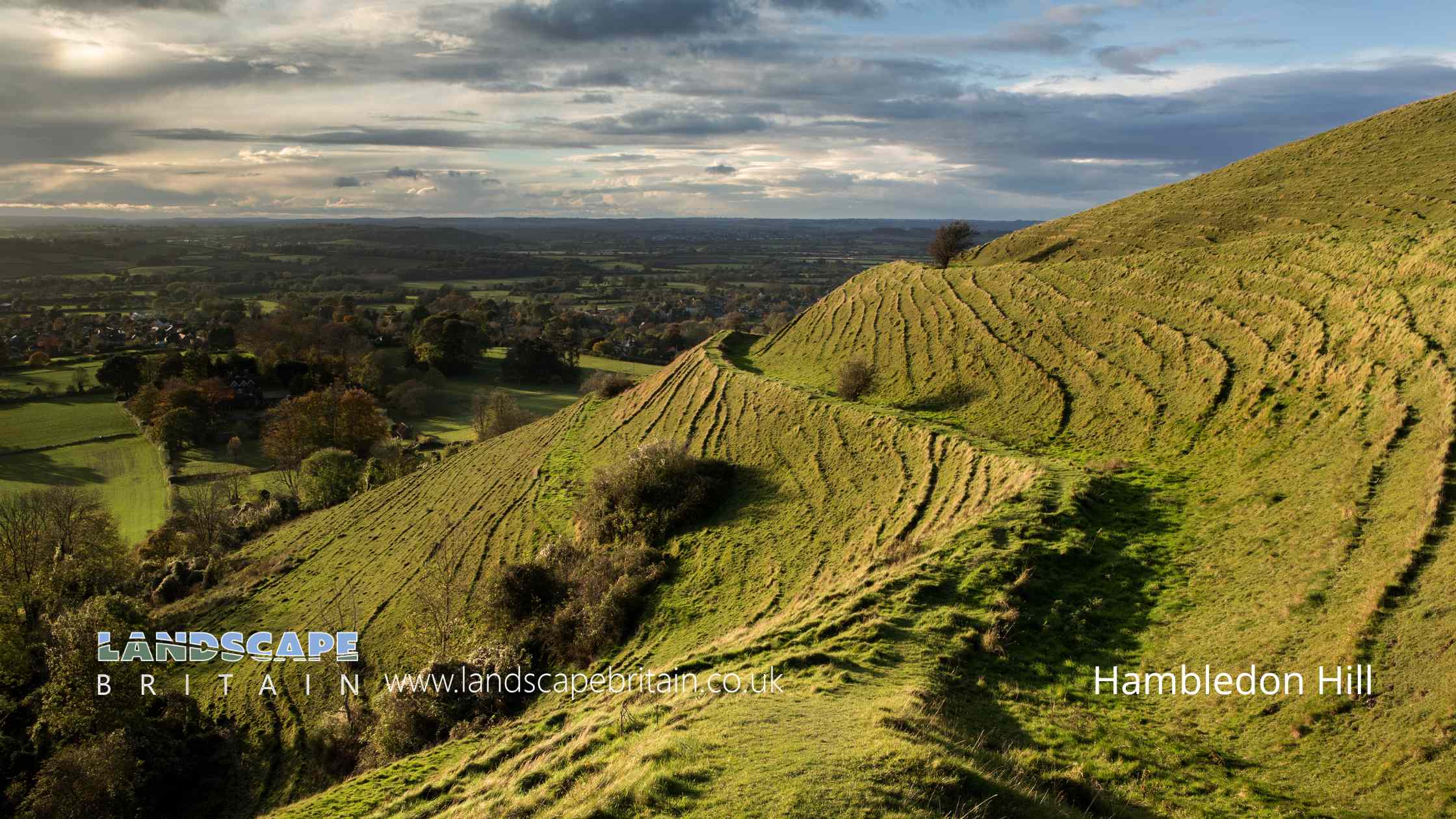
Hambledon Hill is a significant archaeological and historical site located in Dorset, England. This hillfort is renowned for its extensive prehistoric earthworks and its strategic positioning, offering expansive views over the surrounding countryside.
Historical Significance
Hambledon Hill is primarily known for its Iron Age hillfort, which dates back to around 2,500 years ago. The hillfort was constructed by ancient communities who used it as a defensive stronghold. However, the history of Hambledon Hill stretches back even further, into the Neolithic period, around 5,500 years ago. During this time, the hill was used as a site for ceremonial and ritualistic activities, evidenced by the presence of long barrows and other burial mounds.
Archaeological Features
The hillfort at Hambledon Hill is characterized by a series of impressive earthworks, including multiple ramparts and ditches. These fortifications would have provided significant defense against invaders. The ramparts are built from chalk, a material readily available in the area, and their construction demonstrates sophisticated engineering skills.
In addition to the Iron Age defenses, Hambledon Hill contains remnants of Neolithic activity, such as long barrows. These long barrows are burial mounds that were used for communal burials. The most notable of these is the Hambledon Hill Long Barrow, which is one of the best-preserved examples in Britain.
Ecological and Landscape Importance
Hambledon Hill is not only an archaeological treasure but also a site of considerable ecological importance. It is a part of the Cranborne Chase Area of Outstanding Natural Beauty (AONB) and is designated as a National Nature Reserve. The hill supports a diverse range of flora and fauna, including rare chalk grassland species. Its management aims to preserve both its natural and historical heritage.
Modern Significance
Today, Hambledon Hill is managed by the National Trust and is open to the public. Visitors can explore its ancient earthworks, enjoy panoramic views, and learn about its rich history through informational displays and guided tours. The site offers a unique opportunity to experience a landscape that has been continuously used and valued by humans for millennia.
In summary, Hambledon Hill hillfort is a multifaceted site of great archaeological, ecological, and historical value. It offers insights into the lives of our ancient ancestors and stands as a testament to their ingenuity and connection to the landscape.
Created: 25 May 2024 Edited: 10 June 2024
Hambledon Hill Details
Hambledon Hill is a 192.2 metre high hill in Dorset.
Hambledon Hill Information
Hambledon Hill Address
Hambledon Hill, Blandford Forum DT11 8EE, UK
DT11 8EE
Hambledon Hill Woodland
Hambledon Hill is a woodland area in Dorset, managed by Natural England.Hambledon Hill LiDAR Map

Contains public sector information licensed under the Open Government Licence v3.0
Local History around Hambledon Hill
There are some historic monuments around including:
Bowl barrow 800m north west of North Barn Farm on Houghton North DownField system in Old ParkBowl barrow 220m north west of Gore FarmCross dyke and linear boundary on Melbury Hill and Compton DownEarthworks on RingmoorEarthwork S of Meriden Wood, and adjoining round barrowPillow mound on Okeford Hill 660m east of Hartcliff FarmBowl barrow known as Folly BarrowEarthworks on site of manor houseLazerton Farm causewayed roadBowl barrow 800m SSE of Brooks Farm on Bell HillSt Leonard's ChapelSt Mary's Church, remains of, East ComptonMoated site 130m west of Bere Marsh FarmCausewayed camp on Hambledon HillRoman villa 300yds (270m) W of Park House Farm buildingsCross dyke 480m and 690m NNW of Fontmell Hill HouseMelbury Beacon and circular enclosure on Melbury HillBowl barrow 900m north west of Pond Down BuildingsMedieval strip lynchets 450m south of Springhead FarmHambledon Hill campHod Hill camp and Lydsbury RingsCross dyke and bowl barrow on Bell Hill 690m north east of Baker's FollyCross dyke on Okeford Hill 880m south east of Hartcliff FarmCross dyke on Bell Hill 610m east of Brooks FarmMedieval cross base 150m south of Holy Rood ChurchRowbarrow, 500m north west of Hedge End FarmDeserted medieval village at Darknoll FarmEarthworks in Ditchey CoppiceTwo bowl barrows 350m south west of Keeper's Lodge south east of Bareden DownTwo bowl barrows west of Bonsley Common, 900m NNE of Turnworth HousePillow mound on Okeford Hill 690m east of Hartcliff FarmCross dyke on Okeford Hill 1km south west of Broughton HouseMedieval standing cross 30m south of the Church of St PaulTwo cross dykes on Fontmell Down, 850m and 880m south east of Gourd's FarmFiddleford ManorBowl barrow 800m east of Gourd's FarmBowl barrow on Okeford Hill 760m ESE of Hartcliff Farm.


