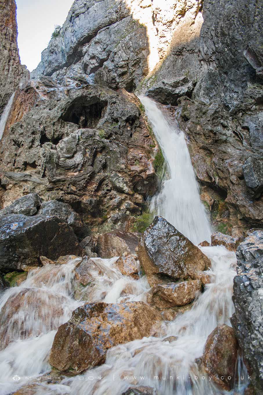
Gordale Scar Lower Waterfall by munki-boy
Gordale Scar Lower Waterfall
Gordale Scar Lower Waterfall is in The Yorkshire Dales National Park in England.
The lower waterfall at Gordale Scar is the barrier for people who turn back down the path from the scar, and those who climb and continue on. The rocks are slippy and treacherous in bad weather but it is not too bad a climb for the able bodied. Once past the waterfall there is a rocky path - sometimes a bit of a scramble.
Created: 24 July 2019 Edited: 29 November 2023
Malham Tarn Estate Information
Malham Tarn Estate Address
Yorkshire Dales Estate Office, Pennine Way, Settle BD24 9PT, UK
BD24 9PT
Website: https://www.nationaltrust.org.uk/malham-tarn-estate
Get directionsGordale Beck from Source to Malham Beck Details
Gordale Beck from Source to Malham Beck
Gordale Beck from Source to Malham Beck is a river in West Yorkshire
Gordale Beck from Source to Malham Beck takes in water from an area around 12.61 km2 in size and is part of the Aire Upper catchment area.
Gordale Beck from Source to Malham Beck is 7.225 km long and is not designated artificial or heavily modified.
Gordale Scar Lower Waterfall LiDAR Map
please wait...
Contains public sector information licensed under the Open Government Licence v3.0
Local History around Gordale Scar Lower Waterfall
There are some historic monuments around including:
Farmhouse sites on Highfolds ScarKilnsey Moor settlementPillow mounds east of Friars Head, known as Giants' GravesSettlement on Cow Bank 1/4 mile (400m) NW of DarnbrookSettlement N of Stridebut EdgeMedieval settlements and lynchets extending NW from Town HeadSettlement on Ing ScarFarm sites and field systems on Malham LingsRound cairn on Broad FlatsSettlement 1250yds (1140m) NE of Malham Tarn HouseSettlement on Prior RakesSettlement at Dew BottomsField system S of Malham CoveSettlement on Blue ScarCrane Field round barrowPikedaw Hill southern cairnHut circles, enclosures and fields N of Shorkley HillDruid's Altar four poster stone circleMedieval monastic wayside cross baseHut circle on Comb ScarCup marked rock in wall east of Scarnber Wood, 500m north east of Bark Laithe, WinterburnEnclosure and hut circles on Prior RakesMedieval monastic wayside cross baseLynchets N of Malham villageMedieval monastic wayside cross base, Water Sinks GateTwo rectangular house sites on Malham LingsRing cairn north west of Ewe MoorCairn on Blue Scar 460m NW of Springs CaveEnclosure E of Malham LingsRound barrow north of Moor Syke, Crane FieldCairn 80m north of Pikedaw Hill'Douky Bottom Cave' Hawkswick Clowder, near KilnseyRoman temporary camp and medieval monastic cross base, Mastiles Lane.Settlement 1/3 mile (540m) NW of Langscar GateSeaty Hill round cairnEnclosed prehistoric settlement east of Malham CoveSettlement 500ft (150m) NW of Ing Scar CragCairn on Great Close HillRound barrow 550m south west of Park HillRound cairn south east of Broad FlatsSheriff Hill round cairnLime kiln and associated quarry 75m south of High Scarth BarnRound barrow 400m south west of Crane Field LaitheLower Colgarth Hill round cairnSettlement SE of Druid's AltarSettlement sites on Jorden Scar.